A data analysis method, equipment and computer storage medium for surveying and mapping information data of land planning, surveying and surveying projects

A technology of information data and analysis methods, applied in soil material testing, surveying, mapping and navigation, measuring instruments, etc., can solve problems such as limitations and errors of land surveying and mapping data, waste of human resources and time costs, and affecting the level of surveying and mapping data analysis. , to save human resources and time costs, improve accuracy and reliability, and avoid heavy workload

Active Publication Date: 2022-03-08
广西国土资源规划设计集团有限公司
View PDF6 Cites 0 Cited by
  • Summary
  • Abstract
  • Description
  • Claims
  • Application Information

AI Technical Summary

Problems solved by technology

[0004] 1. The existing land planning surveying and mapping mainly relies on manual field surveying and mapping, that is, the surveyors survey and map various factors in the land area through fixed-point surveying and mapping. This has the problem that the surveying and mapping data of the land area is not comprehensive enough, resulting in limitations and errors in the land surveying and mapping data larger features, thereby reducing the accuracy and reliability of land area mapping data;
[0005] 2. The existing land planning surveying and mapping data analysis methods require a large number of surveyors to record, organize, analyze and evaluate the land surveying and mapping data, which not only has the problem of heavy workload of surveying and mapping data analysis, but also wastes a lot of human resources and time costs, thus Reduce the efficiency of land planning, surveying and mapping data analysis, and cannot achieve efficient processing and analysis of land planning, surveying and mapping data, which in turn affects the level of surveying and mapping data analysis of land planning, surveying and surveying projects;

Method used


Image

  • A data analysis method, equipment and computer storage medium for surveying and mapping information data of land planning, surveying and surveying projects

Examples


Embodiment Construction

[0038] The following will clearly and completely describe the technical solutions in the embodiments of the present invention with reference to the accompanying drawings in the embodiments of the present invention. Obviously, the described embodiments are only some of the embodiments of the present invention, not all of them. Based on the embodiments of the present invention, all other embodiments obtained by persons of ordinary skill in the art without creative efforts fall within the protection scope of the present invention.

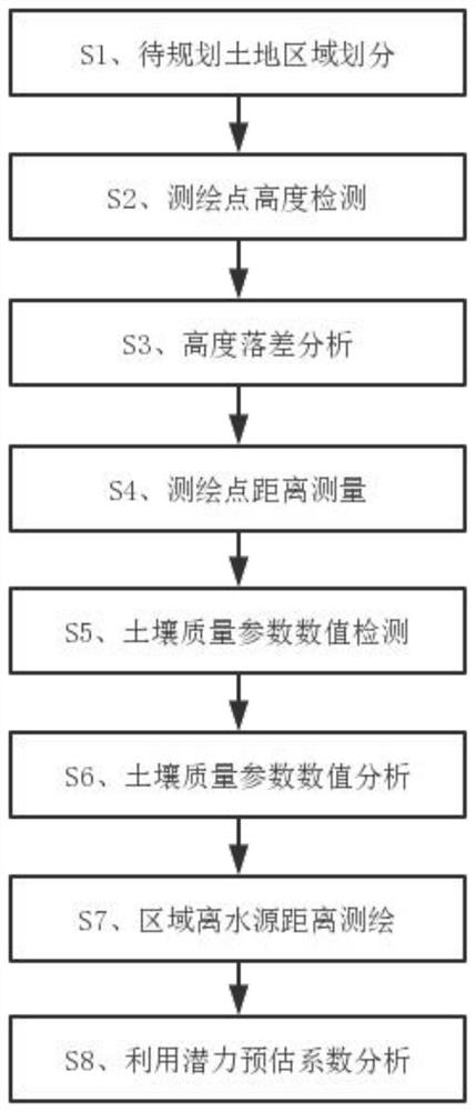
[0039] see figure 1 As shown, the first aspect of the present invention provides a method for data analysis of surveying and mapping information of land planning, surveying and surveying projects, comprising the steps of:

[0040] S1. Division of land areas to be planned: by dividing the land area to be planned in the land survey and survey project, it is divided into sub-areas according to the set length and width division method, and the planned lan...


PUM


Abstract

The invention discloses a data analysis method, equipment and computer storage medium for surveying and mapping information data of land planning survey and survey items. The invention analyzes the terrain of each sub-area in the land to be planned by detecting the height of each surveying and mapping point in each sub-area of ​​the land to be planned The flatness coefficient, and extract the height of the highest surveying point and the lowest surveying point in each sub-area of ​​the land to be planned, analyze the height difference and maximum slope of each sub-area in the land to be planned, and detect the height of each sub-area in the land to be planned The soil quality parameters at each surveying and mapping point are compared to obtain the difference of each soil quality parameter at each surveying and mapping point in each sub-region of the land to be planned, and the distance from each sub-region to the water source in the planned land is surveyed and mapped, and the land to be planned is comprehensively calculated The land use potential estimation coefficient of each sub-region in the land, and the corresponding land use of each sub-region in the land to be planned are screened, so as to realize the efficient processing and analysis of the land planning surveying and mapping data.

Description

technical field [0001] The invention relates to the field of land surveying and mapping data analysis, and relates to a data analysis method, equipment and computer storage medium for land planning, surveying and surveying project surveying and mapping information data. Background technique [0002] Land planning is to classify land use, strengthen land ecological construction, and strengthen land macro-control. In the process of land use planning, it is often necessary to survey and map the land area in order to plan and utilize the land area reasonably. [0003] At present, the existing land planning surveying and mapping data analysis methods have the following problems: [0004] 1. The existing land planning surveying and mapping mainly relies on manual field surveying and mapping, that is, the surveyors survey and map various factors in the land area through fixed-point surveying and mapping. This has the problem that the surveying and mapping data of the land area is ...

Claims


Application Information

Patent Timeline
Patent Type & Authority Patents(China)
IPC IPC(8): G01C15/00G01C5/00G01C9/00G01N33/24
CPCG01C15/00G01C5/00G01C9/00G01N33/24
Inventor 王国炎
Owner 广西国土资源规划设计集团有限公司
Why Eureka
Try Eureka