Maximum sensor data acquisition path planning method and system based on unmanned aerial vehicle group

A technology for path planning and data collection, applied in control/regulation systems, instruments, vehicle position/route/altitude control, etc., and can solve problems such as low efficiency and overlapping coverage areas

Active Publication Date: 2021-09-03
SHANDONG NORMAL UNIV
View PDF8 Cites 3 Cited by
  • Summary
  • Abstract
  • Description
  • Claims
  • Application Information

AI Technical Summary

Problems solved by technology

However, when multiple drones move at the same time, there is a problem of overlapping coverage areas, which will cause multiple drones to collect data in the same area, resulting in inefficiency

Method used


Image

  • Maximum sensor data acquisition path planning method and system based on unmanned aerial vehicle group
  • Maximum sensor data acquisition path planning method and system based on unmanned aerial vehicle group
  • Maximum sensor data acquisition path planning method and system based on unmanned aerial vehicle group

Examples


Embodiment 1

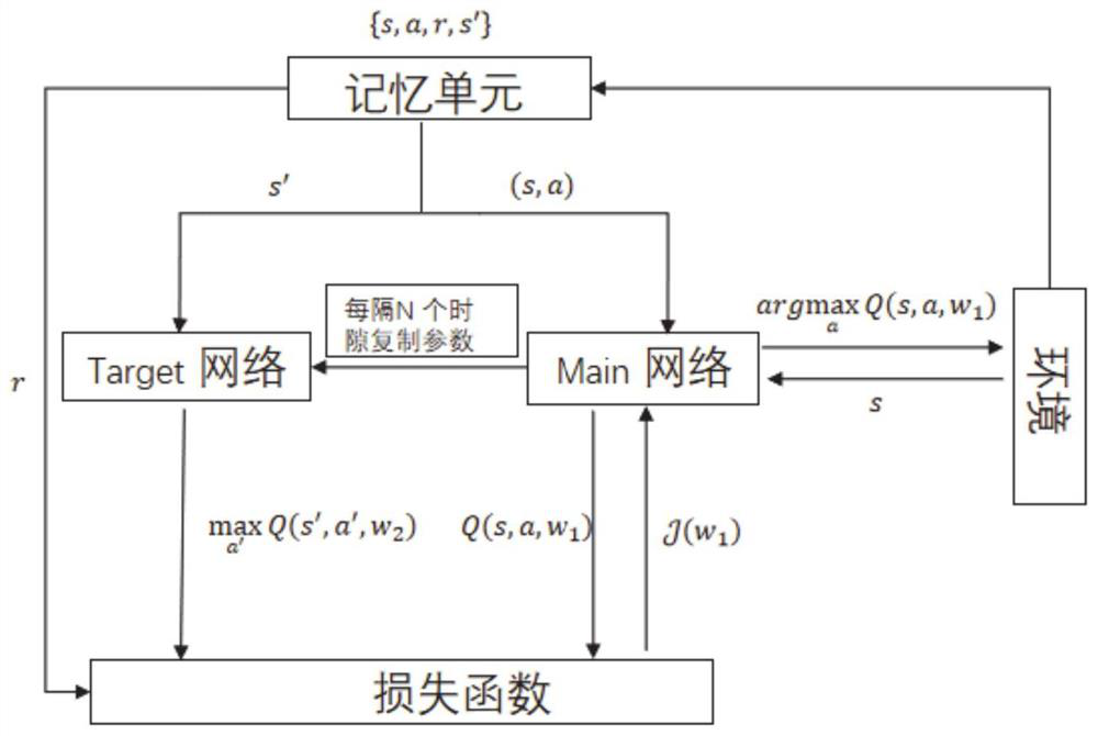
[0038] Such as image 3 As shown, Deep Q-Network (DQN) is one of the main algorithms in deep reinforcement learning. Its algorithm idea is based on the algorithm of value iteration, which uses a deep convolutional network to fit a function representing a state-action pair, so as to solve the problem of large state and action sets and continuous actions. It consists of two neural networks with the same structure but different parameters. One of the deep neural networks is used to evaluate the value function of the current state-action, and the other is used to predict the Q reality and train the network parameters through the loss function. During the training process, the agent collects training data through random sampling to break the correlation between data. Use experience replay techniques during training to improve convergence and stability performance. The general process of DQN is: the agent performs an action based on the current state input, and then obtains the c...

Embodiment 2

[0062] This embodiment provides a method for planning a maximum sensor data collection path based on a UAV swarm.

[0063] The maximum sensor data acquisition path planning method based on UAV swarms, including multiple sensors distributed in a given fixed area to collect surrounding ground environment information, UAV swarms that acquire information collected by sensors, and ground base stations that receive data sent by UAVs, Specifically include the following steps:

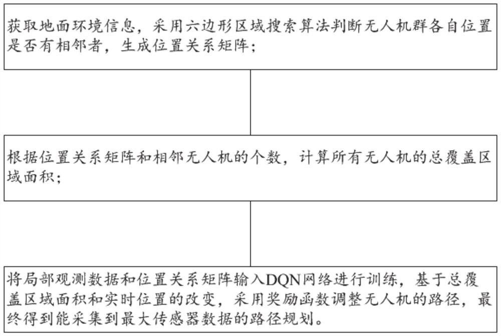
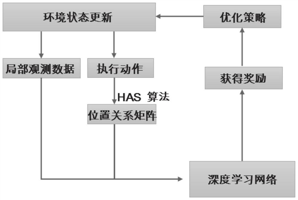
[0064] Obtain the ground environment information collected by the sensor, use the hexagonal area search algorithm to determine whether there are neighbors in each position of the drone group, and generate a position relationship matrix;

[0065] Calculate the total coverage area of ​​all drones according to the position relationship matrix and the number of adjacent drones;

[0066] The ground base station obtains the local observation data and position relationship matrix, and inputs the local observation da...

Embodiment 3

[0111] This embodiment provides a path planning system for maximum sensor data collection based on UAV swarms.

[0112] The maximum sensor data acquisition path planning system based on UAV swarms, including:

[0113] The matrix generation module is configured to: obtain ground environment information, use a hexagonal area search algorithm to determine whether there are neighbors in the respective positions of the drone group, and generate a positional relationship matrix;

[0114] The total coverage area calculation module is configured to: calculate the total coverage area of ​​all drones according to the position relationship matrix and the number of adjacent drones;

[0115] The path planning module is configured to: input the local observation data and position relationship matrix into the DQN network for training, adjust the path of the UAV based on the total coverage area and real-time position, and finally obtain the maximum Path planning for sensor data.


PUM


Abstract

The invention belongs to the field of unmanned aerial vehicle path planning, and provides a maximum sensor data acquisition path planning method and system based on an unmanned aerial vehicle group. The method comprises the following steps of: acquiring ground environment information, judging whether adjacent unmanned aerial vehicle groups exist in their respective positions or not by adopting a hexagonal region search algorithm, and generating a position relation matrix; calculating the total coverage area of all the unmanned aerial vehicles according to the position relation matrix and the number of the adjacent unmanned aerial vehicles; and inputting local observation data and the position relation matrix into a DQN network to train the network, adjusting the paths of the unmanned aerial vehicles by adopting a reward function based on the change of the total coverage area and real-time positions, and finally obtaining a path plan capable of collecting the maximum sensor data.

Description

technical field [0001] The invention belongs to the field of UAV path planning, and in particular relates to a UAV swarm-based maximum sensor data acquisition path planning method and system. Background technique [0002] The statements in this section merely provide background information related to the present invention and do not necessarily constitute prior art. [0003] With the development of the intelligent Internet of Things (IoT), issues such as data storage and collection have become bottlenecks that hinder the interconnection of all things. UAVs are widely used in public and civilian fields due to their flexibility, low cost, and ease of deployment. They can be used for weather monitoring, cargo transportation, etc., replacing humans to work in dangerous and difficult environments. However, the flight path of UAVs has always been a hotspot of related research. Genetic algorithm has been applied to solve the path of UAV, but it is suitable for the situation wher...

Claims


Application Information

Patent Timeline
Patent Type & Authority Applications(China)
IPC IPC(8): G05D1/10
CPCG05D1/104
Inventor 翟临博朱秀敏杨峰赵景梅
Owner SHANDONG NORMAL UNIV
Why Eureka
Try Eureka