Self-adaptive navigation and positioning system and method based on GNSS and INS

A navigation and positioning, self-adaptive technology, applied in the field of navigation and positioning, can solve the problems of satellite signal interference or occlusion, signal interruption, single navigation and positioning system, etc., and achieve the effect of avoiding navigation deviation and reliable positioning accuracy

Inactive Publication Date: 2021-09-07
LIAONING TECHNICAL UNIVERSITY
View PDF1 Cites 4 Cited by
  • Summary
  • Abstract
  • Description
  • Claims
  • Application Information

AI Technical Summary

Problems solved by technology

[0002] After retrieval, Chinese Patent No. CN105472012A discloses a vehicle navigation system and method. Although the invention can change the driving route in real time according to weather information, the navigation and positioning system is single, and it is easy to cause the vehicle to deviate from the original route in complex environments such as tunnels; With the maturity of GNSS technology, more and more satellite navigation devices are used for vehicle navigation; satellite navigation devices estimate their own latitude and longitude information by receiving at least four satellite signals, and compare the latitude and longitude information with the electronic map. So as to determine the current position of the vehicle; the satellite navigation device can also perform the route planning function, that is, plan the path from the starting point to the ending point according to the starting point and the ending point input by the driver, and display the planned path on the display screen , to guide the vehicle, thereby assisting the driver to drive to the destination; the current navigation device can plan the fastest route for the driver; however, in some environmental conditions, it also has natural defects, for example, in dense forests, In the urban environment of tall and dense buildings, under viaducts and tunnels, satellite signals will be interfered or blocked, and signal interruptions occur frequently, which can easily mislead drivers to deviate from the original route; therefore, an autonomous vehicle based on GNSS and INS is invented. Adaptation of navigation and positioning systems and methods has become particularly important;
[0003] Most of the existing vehicle navigation and positioning systems use a single GNSS system or INS system as a vehicle navigation and positioning tool. Although the GNSS system has many advantages, it also has natural defects. , under viaducts and tunnels and other environments, satellite signals are easily interfered or blocked, and it is easy to mislead the driver to deviate from the original route. Although the INS system has the advantages of high short-term accuracy, strong real-time performance, high output frequency, and little interference from the outside world, But its error diverges quickly with time; therefore, we propose an adaptive navigation and positioning system and method based on GNSS and INS

Method used


Image

  • Self-adaptive navigation and positioning system and method based on GNSS and INS
  • Self-adaptive navigation and positioning system and method based on GNSS and INS
  • Self-adaptive navigation and positioning system and method based on GNSS and INS

Examples


Embodiment Construction

[0052] The following will clearly and completely describe the technical solutions in the embodiments of the present invention with reference to the accompanying drawings in the embodiments of the present invention. Obviously, the described embodiments are only some, not all, embodiments of the present invention.

[0053] In describing the present invention, it should be understood that the terms "upper", "lower", "front", "rear", "left", "right", "top", "bottom", "inner", " The orientation or positional relationship indicated by "outside", etc. is based on the orientation or positional relationship shown in the drawings, and is only for the convenience of describing the present invention and simplifying the description, rather than indicating or implying that the referred device or element must have a specific orientation, so as to Specific orientation configurations and operations, therefore, are not to be construed as limitations on the invention.

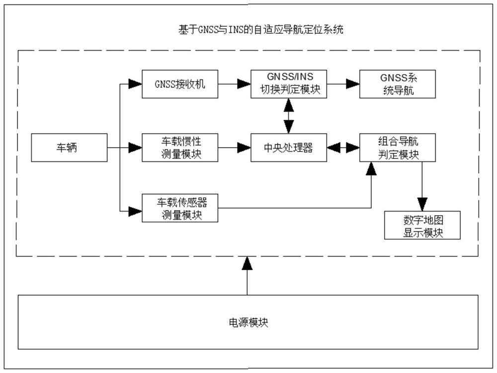
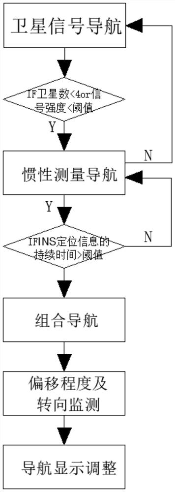
[0054] refer to figure 1...


PUM


Abstract

The invention discloses a self-adaptive navigation and positioning system based on GNSS and INS, which belongs to the technical field of navigation and positioning and comprises a vehicle-mounted GNSS receiver, a GNSS / INS switching judgment module, a central processing unit, a vehicle-mounted inertial measurement module, a combined navigation judgment module, a vehicle-mounted sensor measurement module, a digital map display module and a system power supply module. The integrated navigation system composed of the GNSS and the INS is used for navigating and positioning a vehicle, when a satellite signal is normal, the GNSS is used for navigating independently, and when the GNSS / INS switching judgment module monitors that the satellite signal is weak, the GNSS is switched to the INS for navigating the vehicle. Meanwhile, the combined navigation judgment module records and judges the duration time of the INS positioning information by using a timer, and if the duration time exceeds the threshold time, the GNSS and the INS carry out combined navigation; therefore, the vehicle navigation system can continue to operate stably, reliable positioning precision is obtained, and a driver cannot deviate from an original route.

Description

technical field [0001] The invention relates to the technical field of navigation and positioning, in particular to an adaptive navigation and positioning system and method based on GNSS and INS. Background technique [0002] After retrieval, Chinese Patent No. CN105472012A discloses a vehicle navigation system and method. Although the invention can change the driving route in real time according to weather information, the navigation and positioning system is single, and it is easy to cause the vehicle to deviate from the original route in complex environments such as tunnels; With the maturity of GNSS technology, more and more satellite navigation devices are used for vehicle navigation; satellite navigation devices estimate their own latitude and longitude information by receiving at least four satellite signals, and compare the latitude and longitude information with the electronic map. So as to determine the current position of the vehicle; the satellite navigation devi...

Claims


Application Information

Patent Timeline
Patent Type & Authority Applications(China)
IPC IPC(8): G01C21/18G01C21/16G01S19/47
CPCG01C21/18G01C21/165G01S19/47
Inventor 潘森
Owner LIAONING TECHNICAL UNIVERSITY
Why Eureka
Try Eureka