
Method for fusing digital surface model data based on true orthophoto

A digital surface model and image fusion technology, applied in the field of surveying and mapping science, can solve the problem of insufficient elevation information of real orthodata

Inactive Publication Date: 2021-09-07
广西东方道迩科技有限公司
View PDF6 Cites 2 Cited by
  • Summary
  • Abstract
  • Description
  • Claims
  • Application Information

AI Technical Summary

Problems solved by technology

[0009] The purpose of the present invention is to provide a method for fusing digital surface model data based on real orthophoto images, thereby solving the defect of insufficient representation of elevation information in existing real orthophoto data

Method used


Image

  • Method for fusing digital surface model data based on true orthophoto
  • Method for fusing digital surface model data based on true orthophoto
  • Method for fusing digital surface model data based on true orthophoto

Examples


Embodiment Construction

[0044] The technical solutions in the present invention are clearly and completely described below in combination with the accompanying drawings in the embodiments of the present invention. Obviously, the described embodiments are only some of the embodiments of the present invention, not all of them. Based on the embodiments of the present invention, all other embodiments obtained by persons of ordinary skill in the art without creative efforts fall within the protection scope of the present invention.

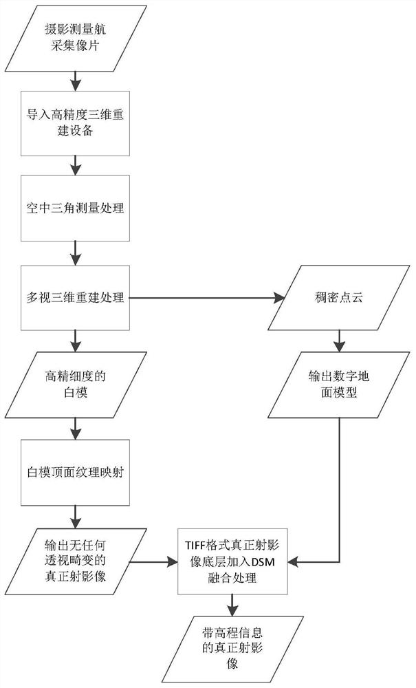
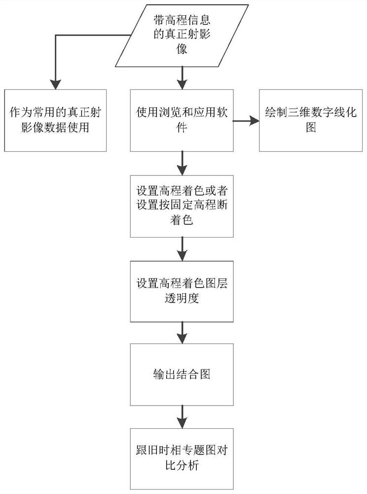
[0045] figure 1 It shows a method for fusing digital surface model data based on real orthoimages in one embodiment provided by the present invention, including the following steps:

[0046] S1. Set aerial photography rules according to the requirements of photogrammetry, and the aerial photography equipment collects original photo data according to the aerial photography rules;

[0047] S2. Carry out aerial triangulation processing on the original photo data to restore the ...


PUM


Abstract

The invention discloses a method for fusing digital surface model data based on true orthophoto, and relates to the field of surveying and mapping science and technology. Aerial photography equipment collects original photo data; aerial triangulation processing is performed on the original photo data, and three-dimensional reconstruction is performed on the data after aerial triangulation processing to obtain dense point cloud intermediate result data and a high-fineness white model; texture mapping is carried out through the top surface data of the high-fineness white model, and a top surface non-perspective image is output to serve as true orthophoto data; a digital surface model is generated by adopting dense point cloud intermediate result data; the digital surface model data is fused with the true orthophoto data to obtain a new true orthophoto with full-range elevation data; the new true orthophoto with the full-range elevation data can be compatible with introduction and use of other true orthophoto tools, the defect that true orthophoto data elevation information is insufficient in expression is overcome, and the utilization value and the use range of photogrammetry results can be greatly increased.

Description

technical field [0001] The invention belongs to the field of surveying and mapping science and technology, in particular to a method for fusing digital surface model data based on real orthoimages. Background technique [0002] Traditional digital orthophotogrammetry was carried out on a large scale only in 1997. After more than ten years of development, orthophoto coverage has been achieved in most developed cities in my country, especially in Guangdong, Jiangsu and Zhejiang, where orthophotos are used as the basis The main digital photogrammetry products have been widely used in various related industries. [0003] However, with the continuous development of image acquisition methods and the higher requirements of various departments for images, more and more large-scale orthophotos have entered the production field. But the large scale presents many new challenges for both aerial photography and office production. In urban areas, it is very difficult to realize the stitc...

Claims


Application Information

Patent Timeline
Patent Type & Authority Applications(China)
IPC IPC(8): G06T15/04G06T15/80G06T17/00G06T19/20
CPCG06T15/04G06T15/80G06T17/00G06T19/20G06T2219/2012
Inventor 何滔龚诚孙冰
Owner 广西东方道迩科技有限公司
Learn More