Urban canyon positioning method based on GNSS/vision/Lidar fusion

A technology of urban canyons and positioning methods, which is applied in the field of satellite positioning and navigation, and can solve problems such as difficult implementation

Pending Publication Date: 2021-09-10
NANJING UNIV OF AERONAUTICS & ASTRONAUTICS
View PDF0 Cites 3 Cited by
  • Summary
  • Abstract
  • Description
  • Claims
  • Application Information

AI Technical Summary

Problems solved by technology

However, shadow matching requires that the 3D city model has high accuracy and can be updated in time, which is often difficult to achieve

Method used


Image

  • Urban canyon positioning method based on GNSS/vision/Lidar fusion
  • Urban canyon positioning method based on GNSS/vision/Lidar fusion
  • Urban canyon positioning method based on GNSS/vision/Lidar fusion

Examples


Embodiment Construction

[0077] Embodiments of the present invention will be described below with reference to the accompanying drawings.

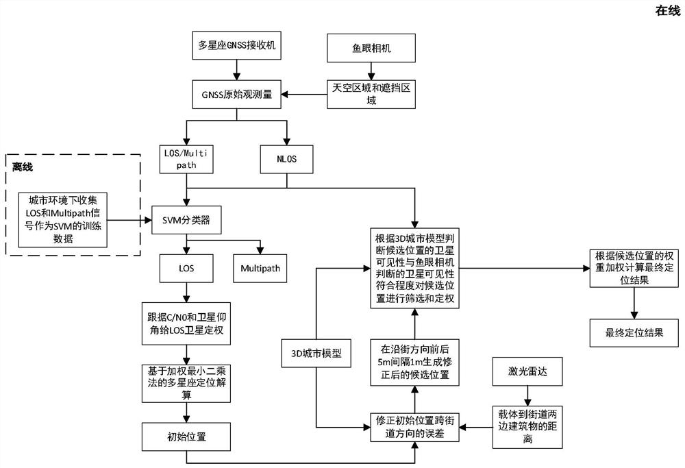
[0078] Such as figure 1 Shown is a flow chart of an urban canyon positioning method based on GNSS / vision / Lidar fusion provided by the embodiment of the present application, including the following steps:

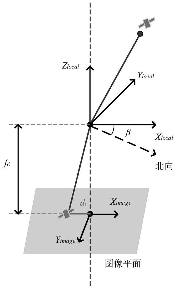
[0079] Step 1, using the fisheye camera to judge satellite visibility;

[0080] Step 2, further judge the signal type of the visible satellite based on the supervised learning method;

[0081] Step 3, determine the weight of the satellite and perform multi-constellation positioning solution based on the satellite weight to obtain the initial positioning solution;

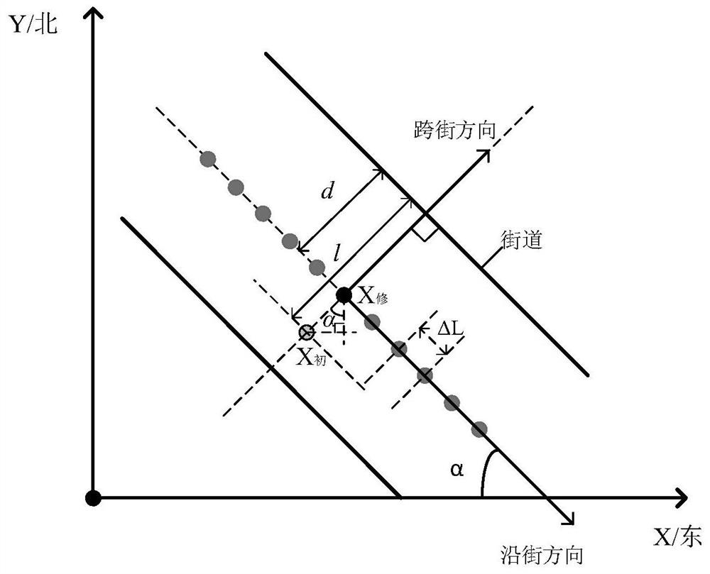
[0082] Step 4, modify the initial positioning solution and generate candidate positions;

[0083] Step 5, screening the candidate positions and calculating the candidate position weights according to the degree of conformity between the satellite visibility of the candidate positions and the satell...


PUM


Abstract

The invention discloses an urban canyon positioning method based on GNSS / vision / Lidar fusion. The method comprises the following steps: 1, judging satellite visibility through a fisheye camera; 2, further judging a satellite signal type based on a supervised learning mode; 3, determining the weight of a satellite, and carrying out multi-constellation positioning calculation based on the weight of the satellite to obtain an initial positioning solution; 4, correcting the initial positioning solution, and generating a candidate position; 5, screening the candidate position and calculating the weight of the candidate position according to the conformity degree of the satellite visibility of the candidate position and the recognized visible satellite in the step 1; and 6, calculating based on the candidate position weight to obtain a final positioning result. According to the method, the precision of the cross-street direction and the along-street direction in urban canyon GNSS positioning is effectively improved, and better real-time performance and convenience are achieved.

Description

technical field [0001] The invention belongs to the technical field of satellite positioning and navigation, and in particular relates to an urban canyon positioning method based on GNSS / vision / Lidar fusion. Background technique [0002] GNSS (Global Navigation Satellite System) can provide space-time information for carriers, and has become an important means to support applications such as urban intelligent transportation. Although GNSS can obtain high-precision positioning information in open areas, in urban canyon environments, because satellites are blocked by tall buildings, multipath (Multipath) and non-line-of-sight (NLOS, Non Line Of Sight) reception, NLOS and The use of Multipath signals in GNSS positioning calculations will reduce positioning accuracy. Therefore, many scholars have proposed a method of excluding reflected signals from GNSS positioning calculations, thereby reducing the impact of reflected signals on GNSS positioning and improving urban canyon posi...

Claims


Application Information

Patent Timeline
Patent Type & Authority Applications(China)
IPC IPC(8): G01S19/45
CPCG01S19/45
Inventor 孙蕊刘正午戴晔莹
Owner NANJING UNIV OF AERONAUTICS & ASTRONAUTICS
Why Eureka
Try Eureka