Longitudinal and latitudinal distance measurement method based on privacy protection and machine load balance

A technology of load balancing and ranging method, which is applied in the field of preprocessing and mobile computing, and can solve the problems of large errors in trajectory distance or environmental factors, and resource consumption.

Inactive Publication Date: 2021-10-08
HARBIN UNIV OF SCI & TECH
View PDF8 Cites 2 Cited by
  • Summary
  • Abstract
  • Description
  • Claims
  • Application Information

AI Technical Summary

Problems solved by technology

[0004] The purpose of the present invention is to propose a longitude and latitude ranging method based on privacy protection and machine load balance, which can effectively improve confidentiality, and solve the problem of large errors in track distance or environmental factors calculated by the haversine formula of latitude and longitude. Resource-consuming issues, lightened load

Method used


Image

  • Longitudinal and latitudinal distance measurement method based on privacy protection and machine load balance
  • Longitudinal and latitudinal distance measurement method based on privacy protection and machine load balance
  • Longitudinal and latitudinal distance measurement method based on privacy protection and machine load balance

Examples


Embodiment Construction

[0040] In order to make the purpose, technical solution and advantages of the method more clear, the method will be described in detail below in conjunction with the accompanying drawings and specific steps.

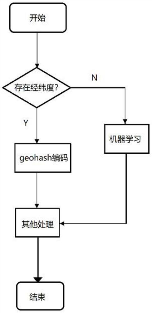
[0041] First of all, we mainly focus on privacy protection and load balancing optimization for coordinate points with longitude and latitude. For location information without coordinates, machine learning is required. Such as figure 1 In the process shown, in step 1, only points with coordinates need to be considered, so binary processing is performed on the longitude and latitude coordinates of each point collected to obtain the new binary longitude and latitude coordinates of this point.

[0042] Using the dichotomy method, the interval is continuously dichotomized, and in the process, a recursive algorithm is used to obtain binary latitude and longitude coordinates.

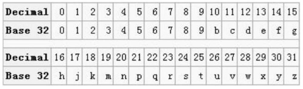
[0043] Go to step 2, according to the obtained binary latitude and longitude coordinates of each poi...


PUM


Abstract

The invention provides a longitude and latitude ranging method based on privacy protection and machine load balance, which comprises the following steps of: firstly, two coordinates of longitude and latitude are represented by using a character string in geohash; in some cases, the indexes cannot be applied on two columns at the same time, and the indexes only need to be applied on one column by utilizing geohash, so that resources and cost consumption are saved. Secondly, the geohash represents a rectangular area instead of a point; and it can be indicated that the user is located near a certain area, the accurate coordinate of the user is not exposed, and privacy protection is facilitated. Third, the encoded prefix may represent a larger region. The characteristic can be used for nearby location search. Firstly, geohash is calculated according to current coordinates of a user, then prefixes of the geohash are taken for query, and all nearby places can be queried. The geohash is more efficient than the calculation (semi-versine formula) directly using longitude and latitude. The method effectively solves the problems of privacy protection and machine load balance.

Description

Technical field: [0001] The invention relates to a longitude and latitude ranging method based on privacy protection and machine load balancing, and belongs to the technical fields of mobile computing, geography and preprocessing. Background technique: [0002] With the development of big data technology and the popularization of mobile terminal equipment, a large amount of trajectory data can be collected and stored on the Internet. Today's easier access to trajectory data has attracted more and more attention from researchers. Because these original trajectory data are affected by sampling frequency, sampling accuracy, and laws and regulations, they usually cannot be directly applied to various mining algorithms. Therefore, they are usually It needs to be preprocessed first. These trajectory data include but are not limited to: social network check-in information, mobile phone signaling data, taxi information, traffic checkpoint passing information, taxi location informat...

Claims


Application Information

Patent Timeline
Patent Type & Authority Applications(China)
IPC IPC(8): G01C1/02G01C21/34
CPCG01C1/02G01C21/3476G01C21/3446
Inventor 任鼎翔裴树军程可吕和翔
Owner HARBIN UNIV OF SCI & TECH
Why Eureka
Try Eureka