An Automatic Calculation Method for Spatial Analysis Based on Metadata

A technology of spatial analysis and automatic calculation, applied in the field of surveying and mapping geographic information, to achieve the effect of simplifying the calculation operation process, avoiding storage, and lowering the threshold for use

Active Publication Date: 2021-12-31
SPEED SPACE TIME INFORMATION TECH CO LTD
View PDF0 Cites 0 Cited by
  • Summary
  • Abstract
  • Description
  • Claims
  • Application Information

AI Technical Summary

Problems solved by technology

But at the same time, there are some problems in this method, that is, users need to understand the structure of feature data, the input and output parameters of analysis methods, and the use of platform modeling tools, which has a certain learning cost

Method used


Image

  • An Automatic Calculation Method for Spatial Analysis Based on Metadata
  • An Automatic Calculation Method for Spatial Analysis Based on Metadata
  • An Automatic Calculation Method for Spatial Analysis Based on Metadata

Examples


Embodiment

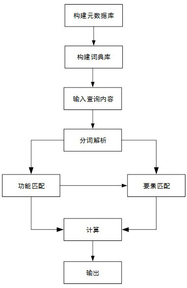
[0046] Example: such as figure 1 As shown, the automatic calculation method of spatial analysis based on metadata includes the following steps:

[0047] S1: Construct element and analysis metadata database;

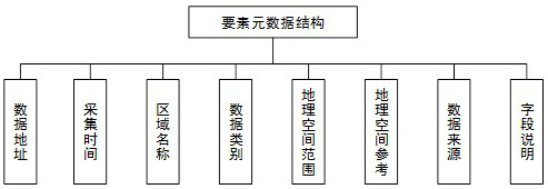
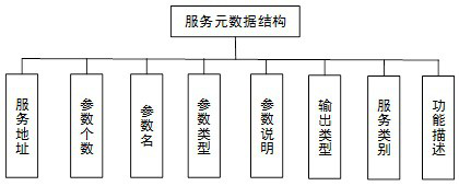
[0048] The element and analysis metadata database in the step S1 includes element metadata and service metadata, and the element metadata includes storage address, acquisition time, area name, data geographic spatial range, geographic spatial reference information, data source, field description and geospatial data category; the service metadata includes service address, parameter number, parameter name, parameter type, parameter description, output type, function description and service category; the specific steps of the step S1 are:

[0049] S11: Record the metadata of each element data according to the element data metadata structure, and store it in the database;

[0050] S12: Record the metadata of each analysis service according to the service metadata structure,...


PUM


Abstract

The invention discloses an automatic calculation method for spatial analysis based on metadata, the steps are: S1: building elements and analyzing metadata database; S2: building a dictionary database according to administrative division names, basic element names and analysis functions; S3: inputting query text , perform word segmentation extraction and word segmentation analysis on the query text, decompose a series of characters into independent and identifiable characters according to certain rules, and obtain word segmentation results of multiple keywords; S4: Based on one of the word segmentation results, step by step Matching, which obtains the service of the word segmentation result after matching, which is recorded as FS; S5: obtains element data based on the remaining word segmentation results and service matching, and is recorded as FD; S6: combines FS and FD for analysis and calculation, and the selected element data The corresponding field value is calculated as the input parameter of the analysis function, the final calculation result is obtained, and the calculation result is output.

Description

technical field [0001] The invention relates to the technical field of surveying and mapping geographic information, in particular to an automatic calculation method for spatial analysis based on metadata. Background technique [0002] With the construction of urban big data, the existing data centers have collected a large amount of geospatial data, with various types of data and a huge amount of data. How to effectively use these rich data resources has become an important issue. For professional algorithm designers, data mining algorithms can be used to mine and extract valuable information from various types of data, while for ordinary users, they rely on the open resource interface supported by the corresponding information system, due to the amount of data Huge and related spatial analysis methods have a certain threshold of use, which limits the effective use of geospatial data by ordinary users to a certain extent. At present, the commonly used method is that the da...

Claims


Application Information

Patent Timeline
Patent Type & Authority Patents(China)
IPC IPC(8): G06F16/33G06F16/38G06F16/387G06F40/242G06F16/29G06F16/9537
CPCG06F16/3334G06F16/3347G06F16/38G06F16/387G06F40/242G06F16/29G06F16/9537
Inventor 冯建亮李俊刘婷婷
Owner SPEED SPACE TIME INFORMATION TECH CO LTD
Why Eureka
Try Eureka