Wheat lodging region identification method based on spectral texture features and support vector machine

A technology of support vector machine and texture feature, applied in the field of agricultural remote sensing, which can solve the problems of being easily affected by weather factors, not very ideal accuracy, and immature technology.

Pending Publication Date: 2021-10-19
CHINA AGRI UNIV
View PDF0 Cites 2 Cited by
  • Summary
  • Abstract
  • Description
  • Claims
  • Application Information

AI Technical Summary

Problems solved by technology

[0009] However, this method is limited by low resolution, unscheduled visit time, and being easily affected by weather factors. Currently, the te

Method used


Image

  • Wheat lodging region identification method based on spectral texture features and support vector machine
  • Wheat lodging region identification method based on spectral texture features and support vector machine
  • Wheat lodging region identification method based on spectral texture features and support vector machine

Examples


Embodiment Construction

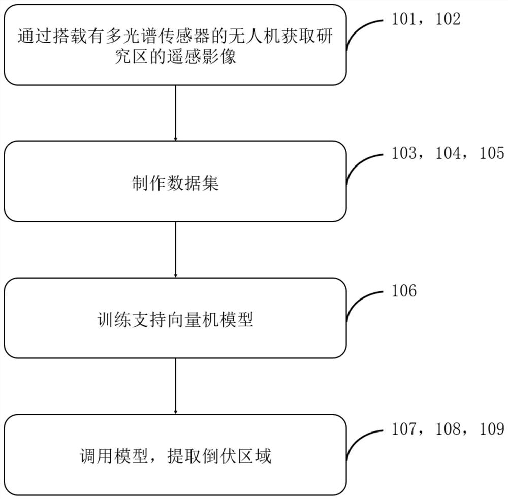
[0043] The following is attached Figure 1-4 The present invention is described in further detail.

[0044] A method for identifying wheat lodging regions based on spectral texture features and support vector machines includes the following steps:

[0045] Step 101: Assembling a multispectral sensor on the UAV platform;

[0046] Step 102: monitor the farmland through the UAV platform equipped with multispectral sensors, and obtain UAV images;

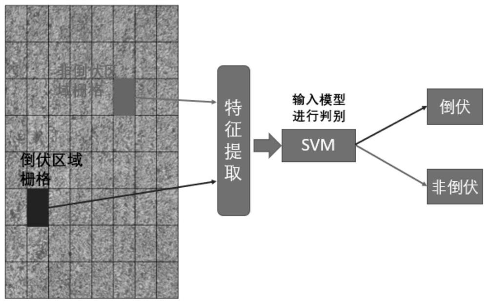
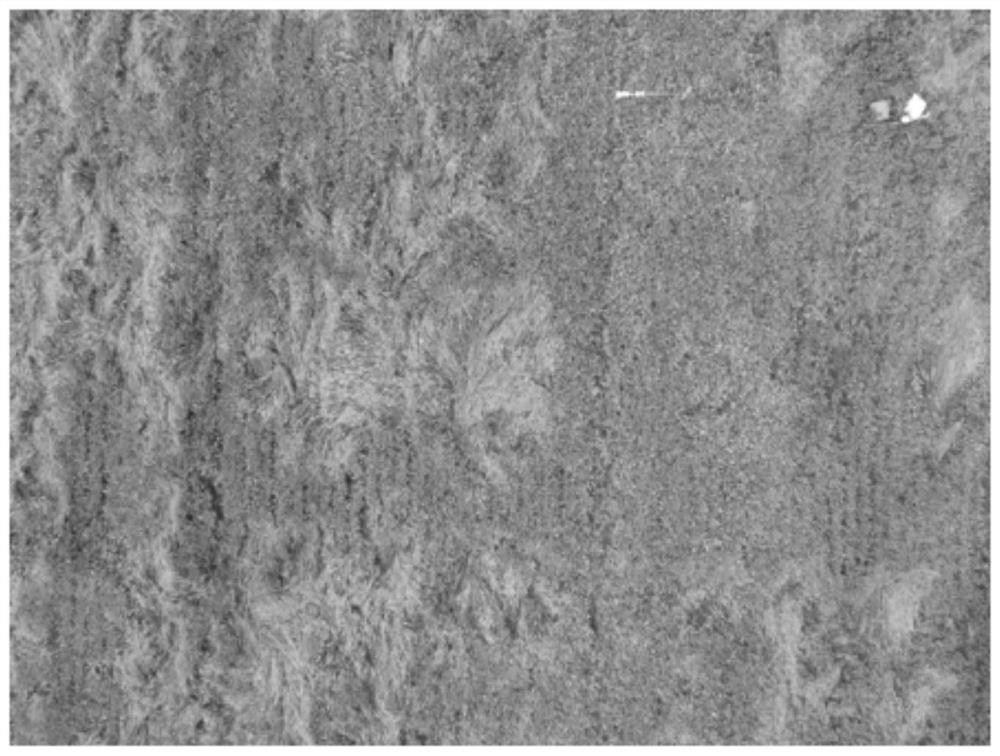
[0047] Step 103: According to each UAV image obtained by UAV platform monitoring, and based on the geographic coordinate information of each pixel, superimpose the single-channel remote sensing images of several bands to generate multiple multi-channel images containing multiple channels. Spectral remote sensing imagery.

[0048] Step 104: Crop the multispectral remote sensing image generated in step 103 according to two categories of lodging and non-lodging by visual estimation, and generate an image containing only lodging areas or...


PUM


Abstract

The invention relates to a wheat lodging area identification method based on spectral texture features and a support vector machine, and the method comprises the steps: assembling a multispectral sensor on an unmanned plane platform, and monitoring a farmland; superposing the single-channel remote sensing images of several wavebands based on the geographic coordinate information of each pixel according to the unmanned aerial vehicle image to generate a plurality of multispectral remote sensing images containing a plurality of channels; through a visual estimation mode, according to lodging and non-lodging types, generating an image with only a lodging area or a non-lodging area in a view field as an original data set; based on a principal component analysis method, calculating texture features of the first two principal components of all the images in the original data set and spectral reflectivity of each pixel in each wave band; constructing a support vector ting machine model and training, presetting the window size, and calling the support vector machine model to judge the type of each window; and counting the number of pixels of all the lodging regions, and further solving the area of the lodging regions.

Description

technical field [0001] The invention relates to the fields of agricultural remote sensing and agricultural disaster assessment, in particular to a method for identifying lodging areas of wheat based on spectral texture features and support vector machines. Background technique [0002] Technical solution of prior art one [0003] The current method for relevant departments to obtain geographical information of the lodging area is: dispatch staff to the affected area; use nylon rope or chalk lime to determine the boundary of the lodging area, outline the boundary of the lodging area, and then use a total station or GPS locator and other tools to determine the geographic coordinates of the corner points, and then use tools such as a tape measure to measure the length of the outline and other information. [0004] The shortcoming of prior art one [0005] This method is time-consuming and labor-intensive, affected by human subjective factors, and the measurement results are c...

Claims


Application Information

Patent Timeline
IPC IPC(8): G06K9/62G06T7/40G06T7/62
CPCG06T7/40G06T7/62G06T2207/30188G06F18/2135G06F18/2411G06F18/214
Inventor 田菲曹文轩鲁赛红乔泽宇
Owner CHINA AGRI UNIV
Why Eureka
Try Eureka