Spatial interpolation method suitable for microwave link monitoring network

A monitoring network and space interpolation technology, applied in the microwave field, can solve problems such as the influence of interpolation results, the difficulty of converting path integral scale data to point scale data, etc., and achieve the effect of solving conversion problems and high coverage

Active Publication Date: 2021-10-26
HOHAI UNIV
View PDF3 Cites 0 Cited by
  • Summary
  • Abstract
  • Description
  • Claims
  • Application Information

AI Technical Summary

Problems solved by technology

[0003] Purpose of the invention: In order to overcome the deficiencies in the prior art, the present invention provides a spatial interpolation method suitable for microwave link monitoring networks, which solves the impact of link area aggregation on interpolation results and the path integral scale data to point scale Data Transformation Problems

Method used


Image

  • Spatial interpolation method suitable for microwave link monitoring network
  • Spatial interpolation method suitable for microwave link monitoring network
  • Spatial interpolation method suitable for microwave link monitoring network

Examples


Embodiment Construction

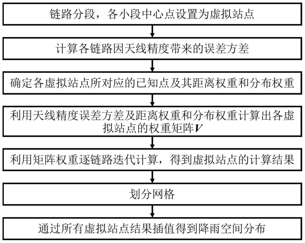
[0051] Below in conjunction with accompanying drawing, the present invention will be further described,

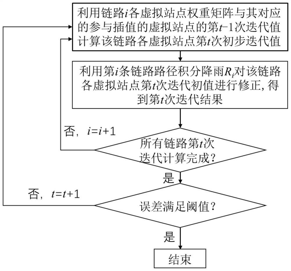
[0052]Such as figure 1 As shown, the spatial interpolation method applicable to the microwave link monitoring network of the present invention comprises the following steps: for three microwave links in the square area:

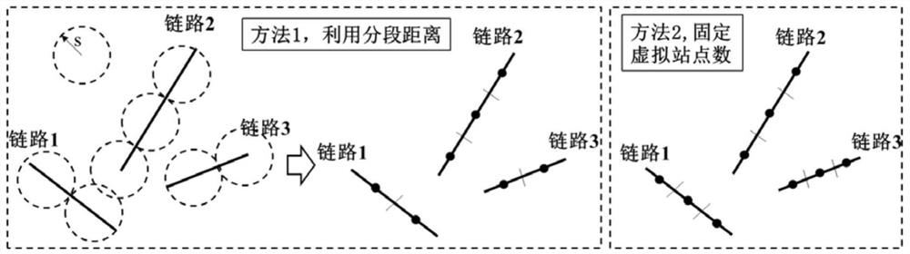
[0053] S1, segment each link, and directly specify the number of virtual sites to be divided by each link is the same value m k =3, all the links are equally divided into 3 sections, and the midpoint of each section is used as the location of the virtual site;

[0054] S2. Calculate the error variance of each link due to the antenna accuracy:

[0055]

[0056] Among them, Q k is the lowest value of the antenna accuracy of the kth link; a k , b k It is the ITU-R model parameter value corresponding to the frequency microwave, and its value is related to the microwave frequency, polarization mode and rainfall particle shape, which can be found in the...


PUM


Abstract

The invention discloses a spatial interpolation method suitable for a microwave link monitoring network, and the method comprises the following steps: segmenting a link, and taking the central point of each segment as the position of a virtual site; calculating the error variance of each link caused by the antenna precision; determining known points corresponding to each virtual site in all links and distance weights and distribution weights of the known points; calculating a weight matrix of each virtual site by using the antenna precision error variance, the distance weight and the distribution weight; performing iterative calculation link by link by using the matrix weight to obtain a calculation result of each link virtual site; dividing grids; and obtaining rainfall spatial distribution through interpolation of all virtual station results. According to the method, rainfall information captured by other links can be utilized through step-by-step iterative optimization of the sub-links, the advantage of high coverage rate of a microwave link network is exerted to a greater extent, and the problem of conversion from path integral data to point scale data is solved.

Description

technical field [0001] The invention relates to a space interpolation method suitable for a microwave link monitoring network, belonging to the microwave field. Background technique [0002] In recent years, the technology of rainfall monitoring using microwave link network has been widely concerned. However, a problem restricting the development of this technology is how to use the monitoring results of the monitoring network to obtain the spatial distribution of rainfall. Different from other data types, microwave link monitoring results are path integral scales, which cannot be applied to existing applications; in addition, due to the general situation of regional aggregation in microwave link networks, the small area aggregation of such links will The result of spatial interpolation becomes very inaccurate, and the monitoring advantages of the microwave link network cannot be correctly expressed. Contents of the invention [0003] Purpose of the invention: In order t...

Claims


Application Information

Patent Timeline
Patent Type & Authority Applications(China)
IPC IPC(8): G06F30/20G06T3/40G06F111/02
CPCG06F30/20G06T3/4007G06F2111/02Y02A90/10
Inventor 郑鑫王倩杨涛陈志远魏兴媛洪岱
Owner HOHAI UNIV
Why Eureka
Try Eureka