Multi-mode comprehensive pollution tracing method
A pollution traceability, multi-mode technology, applied in measurement devices, instruments, scientific instruments, etc., can solve the problems of difficult closed monitoring of open spaces, irregular emissions, and unfavorable sailing speed, etc., to improve the accuracy of traceability and traceability. Accurate effect
- Summary
- Abstract
- Description
- Claims
- Application Information
AI Technical Summary
Problems solved by technology
Method used
Image
Examples
Embodiment 1
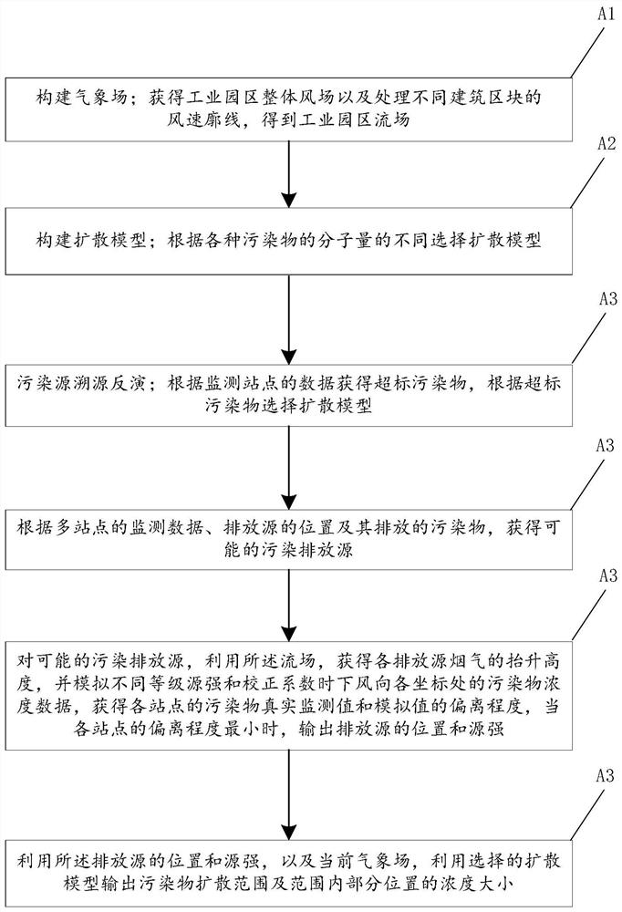
[0023] figure 1 The flow chart of the multi-mode comprehensive pollution traceability method of the embodiment of the present invention is given, as figure 1 As shown, the multi-mode comprehensive pollution traceability method includes the following steps:
[0024] (A1) Construct a meteorological field; obtain the overall wind field of the industrial park and process the wind speed profiles of different building blocks to obtain the flow field of the industrial park;
[0025] (A2) Build a diffusion model; select the diffusion model according to the molecular weight of various pollutants, and the diffusion model includes a Gaussian plume diffusion model and a SLAB diffusion model;
[0026] (A3) Pollution source traceability and inversion; obtain excessive pollutants according to the data of monitoring stations, and select a diffusion model according to the excessive pollutants;
[0027] According to the monitoring data of multiple sites, the location of the emission source an...
Embodiment 2
[0046] An application example of the multi-mode comprehensive pollution traceability method according to Embodiment 1 of the present invention in an industrial park.
[0047] In this application example, the multi-mode comprehensive pollution traceability method includes the following steps:
[0048] (A1) Construct the meteorological field; obtain the overall wind field of the industrial park and the wind speed profiles of different building blocks, and obtain the flow field of the industrial park. The way to construct the meteorological field is:
[0049] Obtain the three-dimensional structure of the buildings in the industrial park, and mark the type and purpose of the buildings;
[0050] Layout monitoring points in the industrial park grid to obtain pollutant data and meteorological data;
[0051] Combining the meteorological data and the data of the Meteorological Bureau, use the WRF model to simulate the overall wind field of the industrial park;
[0052] The building d...
PUM
 Abstract
Description
Claims
Application Information
 - R&D
- Intellectual Property
- Life Sciences
- Materials
- Tech Scout
- Unparalleled Data Quality
- Higher Quality Content
- 60% Fewer Hallucinations
Browse by: Latest US Patents, China's latest patents, Technical Efficacy Thesaurus, Application Domain, Technology Topic, Popular Technical Reports.
© 2025 PatSnap. All rights reserved.Legal|Privacy policy|Modern Slavery Act Transparency Statement|Sitemap|About US| Contact US: help@patsnap.com


