Road surface flatness detection method based on line scanning three dimensions

A technology of line scanning and flatness, which is applied in the direction of measuring devices, instruments, and optical devices, etc., can solve the problems of not being able to truly reflect the flatness of the road surface, and the accuracy of determining the flatness of the road surface is reduced.

Pending Publication Date: 2021-11-26
WUHAN WUDA ZOYON SCI & TECH
View PDF0 Cites 1 Cited by
  • Summary
  • Abstract
  • Description
  • Claims
  • Application Information

AI Technical Summary

Problems solved by technology

[0004] However, there is a certain deviation between the road surface data obtained by using the existing technology and the actual road surface data, which cannot truly reflect the smoothness of the road surface, which reduces the accuracy of determining the smoothness of the road surface

Method used


Image

  • Road surface flatness detection method based on line scanning three dimensions
  • Road surface flatness detection method based on line scanning three dimensions
  • Road surface flatness detection method based on line scanning three dimensions

Examples


Embodiment Construction

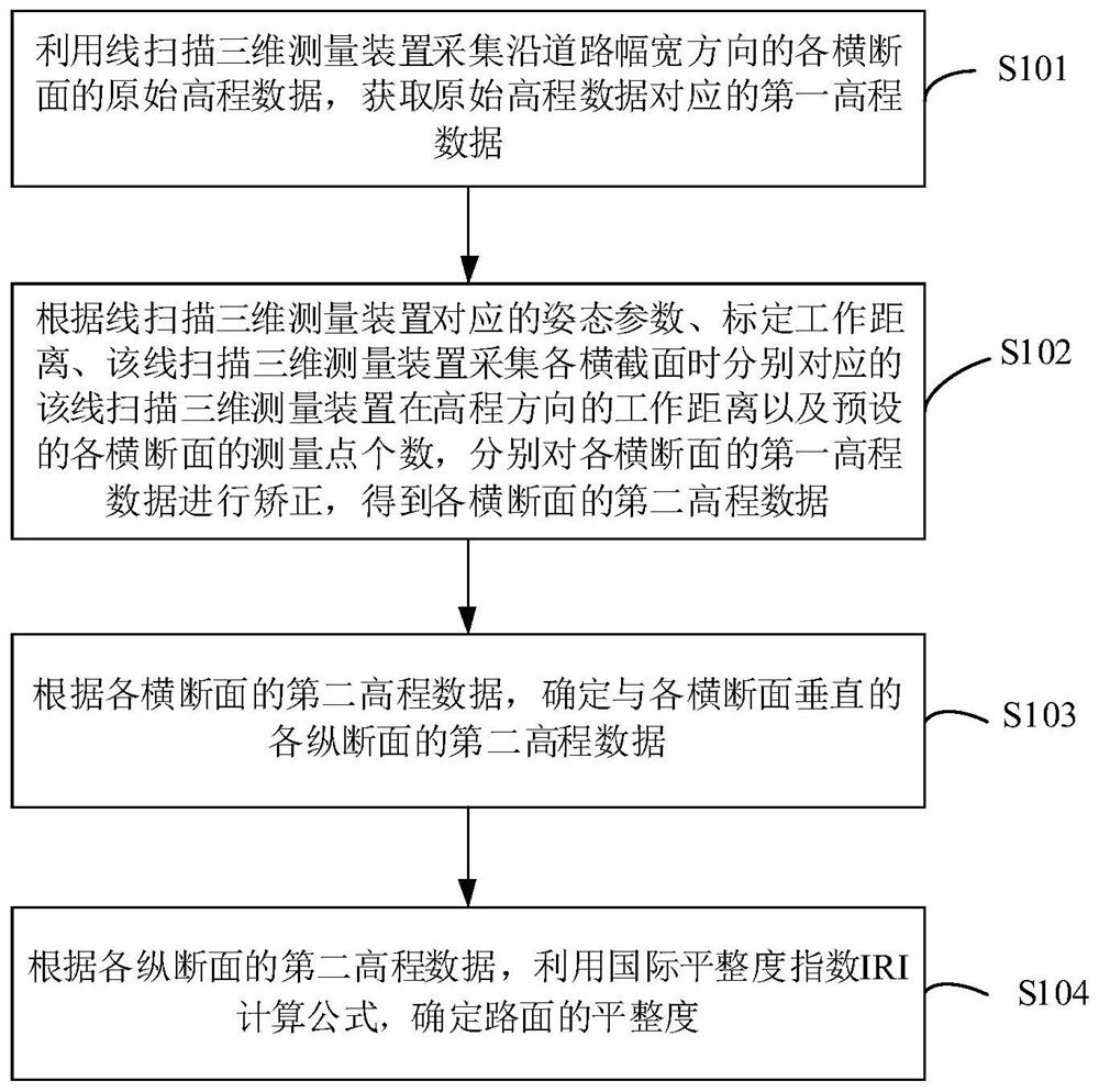
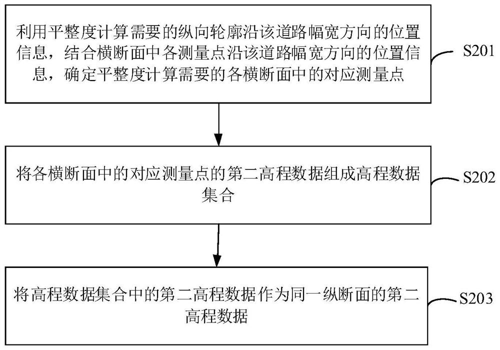
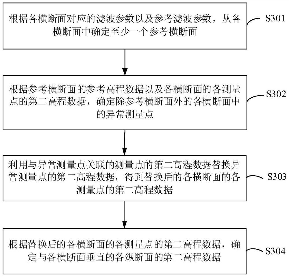
[0045] In order to make the purposes, technical solutions and advantages of the embodiments of the present application clearer, the technical solutions in the embodiments of the present application will be clearly and completely described below in conjunction with the drawings in the embodiments of the present application. Obviously, the described embodiments It is a part of the embodiments of this application, not all of them.

[0046] Accordingly, the following detailed description of the embodiments of the application, which are provided in the accompanying drawings, is not intended to limit the scope of the claimed invention, but merely represents selected embodiments of the application. Based on the embodiments in this application, all other embodiments obtained by persons of ordinary skill in the art without creative efforts fall within the protection scope of this application.

[0047] It should be noted that like numerals and letters denote similar items in the followi...


PUM


Abstract

The invention provides a road surface flatness detection method based on line scanning three dimensions, and relates to the technical field of road surface measurement engineering. The method comprises the following steps: acquiring original elevation data of each cross section along the breadth direction of a road by utilizing a line scanning three-dimensional measurement device, and obtaining first elevation data corresponding to the original elevation data; correcting the first elevation data of each cross section according to attitude parameters corresponding to the line scanning three-dimensional measurement device, the calibrated working distance, the working distance of the line scanning three-dimensional measurement device in the elevation direction when the line scanning three-dimensional measurement device collects each cross section, and the preset number of measurement points of each cross section; obtaining second elevation data of each cross section, and further determining second elevation data of each vertical section perpendicular to each cross section; and according to the second elevation data of each longitudinal section, determining the flatness of the pavement by using an international flatness index IRI calculation formula. Therefore, the accuracy of determining the pavement flatness can be improved.

Description

technical field [0001] The present application relates to the technical field of road surface measurement engineering, in particular, to a three-dimensional line-scanning-based method for detecting road surface roughness. Background technique [0002] Road surface roughness not only affects the driving comfort of drivers and passengers, but also causes vehicle vibration, tire wear and vehicle running speed instability, so the determination of road surface roughness is a very important task in road surface measurement engineering . [0003] At present, the IRI (International Roughness Index, International Roughness Index) is usually used to evaluate the road surface roughness, and three-dimensional laser scanning can be used to obtain the road surface data required for calculating the International Roughness Index IRI. [0004] However, there is a certain deviation between the road surface data obtained by using the existing technology and the actual road surface data, which...

Claims


Application Information

Patent Timeline
Patent Type & Authority Applications(China)
IPC IPC(8): G01B11/30
CPCG01B11/30
Inventor 曹民林红王新林卢毅邢旭凯严懿高超陈琪
Owner WUHAN WUDA ZOYON SCI & TECH
Why Eureka
Try Eureka