Three-dimensional oblique photogrammetry system for surveying

An oblique photogrammetry and three-dimensional technology, which is applied in the field of three-dimensional oblique photogrammetry system for surveying, can solve the problems of feasibility analysis of unmeasured areas, unavailable route analysis, and increased accident rate of measuring equipment, so as to avoid inaccurate and timely measurement Effects of adjustment, prevention of low measurement accuracy, and improvement of measurement accuracy

Active Publication Date: 2021-11-26
浙江天赞规划勘测设计有限公司
View PDF3 Cites 5 Cited by
  • Summary
  • Abstract
  • Description
  • Claims
  • Application Information

AI Technical Summary

Problems solved by technology

[0003] However, in the existing technology, the feasibility analysis of the measurement area cannot be carried out, and the photogrammetry is still carried out in the area where the photogrammetry cannot be performed, resulting in a decrease in measurement efficiency. At the same time, it is not possible to analyze the routes in each area, resulting in an increase in the accident rate of the measurement equipment. , increasing the measurement cost indirectly reduces the measurement efficiency; in addition, the accuracy test cannot be performed on the real-time measurement equipment, and the measurement equipment cannot be adjusted in real time, resulting in a decrease in the quality of the measurement and low numerical accuracy;

Method used


Image

  • Three-dimensional oblique photogrammetry system for surveying

Examples


Embodiment Construction

[0030] The technical solutions of the present invention will be clearly and completely described below in conjunction with the embodiments. Apparently, the described embodiments are only some of the embodiments of the present invention, not all of them. Based on the embodiments of the present invention, all other embodiments obtained by persons of ordinary skill in the art without making creative efforts belong to the protection scope of the present invention.

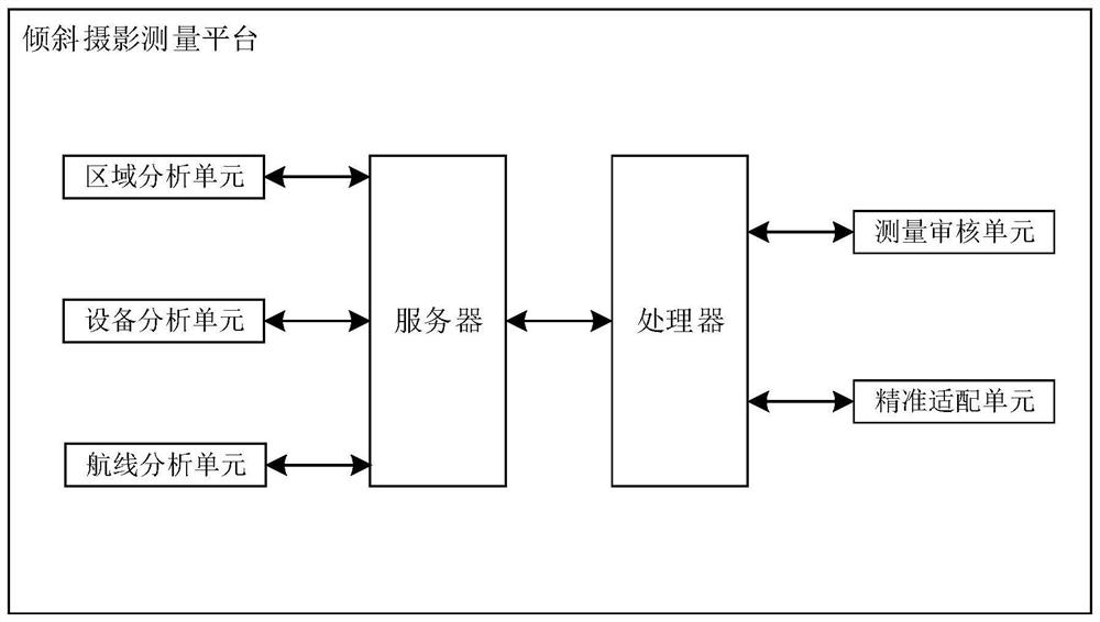
[0031] Such as figure 1 As shown, a three-dimensional tilted photogrammetry system for surveying includes a tilted photogrammetry platform, and a server and a processor are arranged in the tilted photogrammetry platform, wherein the server and the processor are connected by two-way communication, and the server is connected by two-way communication with a regional analysis unit and equipment The analysis unit and route analysis unit; the two-way communication connection of the processor has a measurement audit unit and...


PUM


Abstract

The invention discloses a three-dimensional oblique photogrammetry system for surveying, relates to the technical field of oblique photogrammetry, solves the technical problem of low measurement efficiency caused by incapability of performing feasibility analysis on a measurement area in the prior art, and judges whether each sub-area is suitable for oblique photogrammetry or not through environment analysis, the problems that the damage rate of oblique photogrammetry flight equipment is increased, the measurement cost is increased and the measurement progress of a survey area is influenced due to the fact that the environment in the sub-area is not suitable for measurement are prevented; the cost performance of the flight route is judged and measured, equipment faults caused by the flight route are reduced, and the accuracy of measurement is improved; the accuracy of constructing the three-dimensional model is judged and measured, the low measurement precision is prevented, the measurement times are increased, the accident risk is increased, and the measurement cost is increased at the same time; flight equipment for real-time measurement is reasonably deployed, the measurement accuracy is improved, and the situation that measurement is inaccurate and cannot be adjusted in time, and consequently the measurement efficiency is reduced is avoided.

Description

technical field [0001] The invention relates to the technical field of oblique photogrammetry, in particular to a three-dimensional oblique photogrammetry system for surveying. Background technique [0002] Oblique photography technology is a high-tech developed in the field of international surveying and mapping in recent years. It overturns the previous limitation that orthophotos can only be taken from a vertical angle. Collecting images from five different angles, including four tilts, introduces users to a real and intuitive world that conforms to human vision. Aerial tilted images can not only reflect the real situation of ground objects, but also embed accurate geographic information through the use of advanced positioning technology. Information, richer image information, and more advanced user experience have greatly expanded the application field of remote sensing images, and made the industrial application of remote sensing images more in-depth; [0003] However,...

Claims


Application Information

Patent Timeline
Patent Type & Authority Applications(China)
IPC IPC(8): G01C11/02
CPCG01C11/02
Inventor 陈星陈长红廖志强占金垚
Owner 浙江天赞规划勘测设计有限公司
Why Eureka
Try Eureka