Unmanned aerial vehicle landing platform, identification method, landing method and flight operation system

A technology of landing platform and identification method, applied in control/regulation systems, non-electric variable control, instruments, etc., can solve the problems of easy deviation of landing position, inability to obtain the full picture of the pattern, deviation of the position of the drone, etc., and achieve the landing process. Stable and reliable, simple and reliable calculation results, and sufficient prior information

Pending Publication Date: 2021-12-07
北京理工大学重庆创新中心 +1
View PDF22 Cites 1 Cited by
  • Summary
  • Abstract
  • Description
  • Claims
  • Application Information

AI Technical Summary

Problems solved by technology

During the landing process of the UAV, due to the change of the distance and position from the landing board, its field of view will change. As the distance gets closer, the target will be lost when it approaches the landing platform, and the final landing position is prone to deviation. Low landing accuracy
On the other hand, airflow disturbance may cause the position of the UAV to deviate from the center of the landing board, and it can only "see" a partial position but cannot get a full picture of the pattern. The usual design is to reposition the position of the pattern after pulling the UAV to a certain position , which increases the landing time

Method used


Image

  • Unmanned aerial vehicle landing platform, identification method, landing method and flight operation system
  • Unmanned aerial vehicle landing platform, identification method, landing method and flight operation system
  • Unmanned aerial vehicle landing platform, identification method, landing method and flight operation system

Examples


Embodiment 1

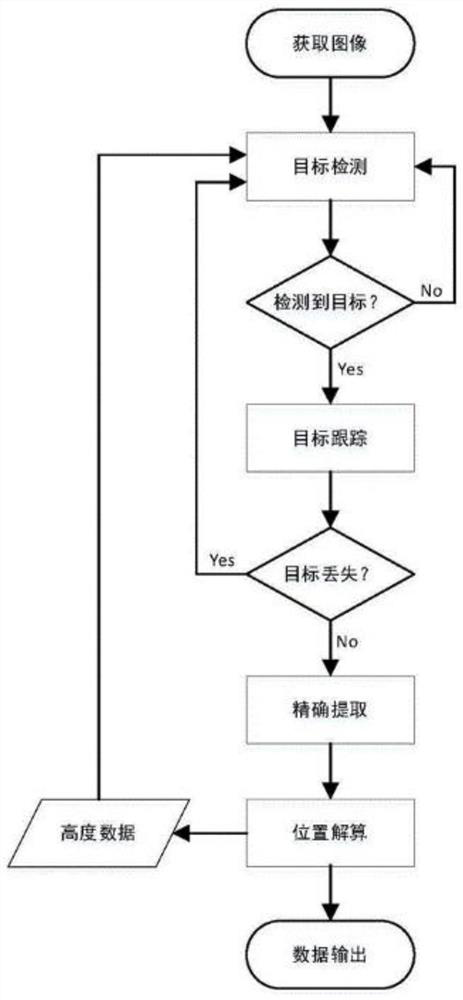
[0056] This embodiment discloses a method for landing an unmanned aerial vehicle. The method includes the steps of collecting images, identifying the landing platform from the collected images, and calculating the relative pose data between the unmanned aerial vehicle and the detected landing platform. Steps, the step of calculating landing navigation information according to the relative pose data, and the step of controlling the UAV to land under the guidance of the landing navigation information.

[0057] The UAV flies normally according to the planned navigation information, and collects the image below after flying to the effective area above the landing point, or after receiving the landing command.

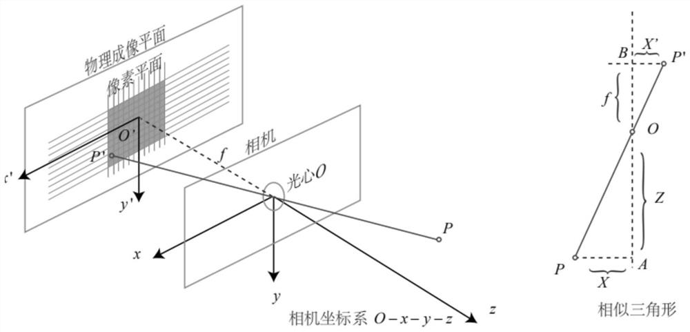
[0058] The so-called landing point is a destination position set in the navigation information. The so-called effective area above the landing point refers to the predetermined height above the landing point. The height h of the UAV is determined comprehensively by the inte...

Embodiment 2

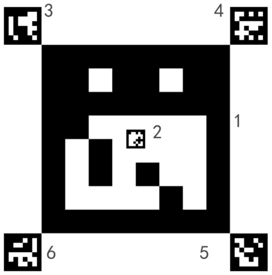
[0104] This embodiment discloses another method for guiding drones to land based on multi-size and nested patterns. This method is generally the same as the method in Embodiment 1, the only difference is that the unique identification The design is not to design with color blocks, but to configure link addresses for each QR code, pointing to a unique logo.

Embodiment 3

[0106] Cameras, radars, IMU (inertial navigation equipment), GPS (global positioning equipment), positioning and navigation equipment, onboard computer, flight control computer, etc. are installed on the UAV. (mav_link) communicates with the flight control computer through the serial port (mavros), and sends flight instructions (such as take-off navigation information, planning navigation information, landing navigation information, etc.) to the flight control computer through the serial port to realize autonomous flight and landing.

[0107] The camera, onboard computer, sub-control computer and landing platform designed with multi-size and nested patterns on the UAV constitute a system to guide the UAV to land.

[0108] The drone flies normally according to the planning navigation information. During the normal flight, the camera is turned off, and the flight of the drone is guided by RTK (Real-time kinematic, real-time differential positioning). After the UAV flies to the e...


PUM


Abstract

The invention discloses an unmanned aerial vehicle landing platform, an identification method, a landing method and a flight operation system. A multi-size nested pattern is arranged on the landing platform, after the unmanned aerial vehicle arrives at a landing point, a main pattern is automatically identified firstly, and a first secondary pattern is automatically identified along with shortening of the distance. A second secondary pattern around the primary pattern is automatically identified when the position is shifted due to airflow disturbance. Therefore, the unmanned aerial vehicle can be guided by the mark image in the whole landing process, and precise landing is achieved. Segmented design is carried out in the landing process, the landing process comprises the three stages of initial acceleration, constant-speed flight and tail-end deceleration, and when the speed is reduced to zero, the unmanned aerial vehicle just lands on the landing platform, and stable landing is achieved. According to the method, the unmanned aerial vehicle can be guided to land to the designated position accurately, stably and efficiently, the pattern target can be recognized in a self-adaptive mode in the landing process, and high robustness and high anti-interference performance are achieved.

Description

technical field [0001] The invention relates to the field of unmanned aerial vehicles, in particular to an unmanned aerial vehicle landing platform, a landing platform identification method, an unmanned aerial vehicle method and a flight operation system. Background technique [0002] With the gradual expansion of the application range of UAV technology in the military and civilian fields, UAVs with precise landing functions have attracted more and more attention, such as precise landing, landing, and fixed-point delivery. Traditional guidance technologies include inertial guidance, radar guidance, and high-precision satellite guidance. The position error of inertial navigation will accumulate and increase over time, affecting navigation accuracy; the positioning accuracy of radar is limited, and the equipment is complicated; high-precision satellite guidance relies on satellite signals, which is susceptible to interference, and it is difficult to guarantee reliability in th...

Claims


Application Information

Patent Timeline
IPC IPC(8): G05D1/06
CPCG05D1/0676
Inventor 刘书林徐彬樊伟刘春桃
Owner 北京理工大学重庆创新中心
Why Eureka
Try Eureka