
Land utilization classification and change prediction method based on deep learning

A technology of deep learning and prediction methods, applied in the field of remote sensing image information, can solve problems such as the inability to predict land use dynamic changes, crop yield prediction, complex division basis, and inaccurate classification

Pending Publication Date: 2021-12-17
HUAZHONG NORMAL UNIV
View PDF0 Cites 0 Cited by
  • Summary
  • Abstract
  • Description
  • Claims
  • Application Information

AI Technical Summary

Problems solved by technology

[0002] Land use classification technology based on high-resolution remote sensing images has been widely used in large-scale land use surveys, but the existing land use classification technology still has difficulties in extracting classification features of land objects, many noise interference factors, and insufficient classification results. In addition, the types of land use are diverse and the basis for classification is complex, and some categories are composed of a variety of different features, resulting in a complex internal structure. Generally, classification methods that rely on remote sensing image features cannot accurately classify complex land use types.
The existing land use classification and change prediction are not combined. When predicting land use change, ordinary classification techniques are often used for classification, resulting in low prediction accuracy, and it is impossible to carry out land use dynamic change prediction, crop yield prediction, natural disasters, etc. A series of work such as prevention and control and rational organization of land use

Method used


Image

  • Land utilization classification and change prediction method based on deep learning

Examples


Embodiment Construction

[0029] The following will clearly and completely describe the technical solutions in the embodiments of the present invention with reference to the accompanying drawings in the embodiments of the present invention. Obviously, the described embodiments are only some, not all, embodiments of the present invention. Based on the embodiments of the present invention, all other embodiments obtained by persons of ordinary skill in the art without making creative efforts belong to the protection scope of the present invention.

[0030] The purpose of the present invention is to provide a land use classification and change prediction method based on deep learning, which can accurately realize land use classification and change prediction, and can provide land use dynamic change prediction, crop yield prediction, natural disaster prevention and rational organization A series of works such as land use provide the basis.

[0031] In order to make the above objects, features and advantages...


PUM


Abstract

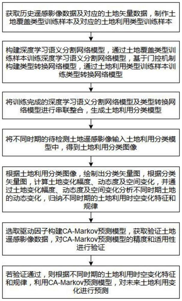
The invention provides a land utilization classification and change prediction method based on deep learning, and the method comprises the steps: making land coverage type training samples and corresponding land utilization type training samples, constructing a deep learning semantic segmentation network model, constructing a type conversion network model based on a gating mechanism, and carrying out the training of the model conversion network model, generating a land utilization classification model according to the deep learning semantic segmentation network model and the type conversion network model, obtaining a land utilization classification image according to the land utilization classification model, selecting driving factors to construct a prediction model, and analyzing and concluding land utilization spatial-temporal change characteristics and laws in different periods according to the land utilization classification image, and using the prediction model to predict the future land utilization change. According to the land utilization classification and change prediction method based on deep learning, land utilization classification and change prediction can be accurately realized, and a basis can be provided for a series of work such as land utilization dynamic change prediction.

Description

technical field [0001] The invention relates to the technical field of remote sensing image information, in particular to a land use classification and change prediction method based on deep learning. Background technique [0002] Land use classification technology based on high-resolution remote sensing images has been widely used in large-scale land use surveys, but the existing land use classification technology still has difficulties in extracting classification features of land objects, many noise interference factors, and insufficient classification results. In addition, the types of land use are diverse and the basis for classification is complex, and some categories are composed of a variety of different features, resulting in a complex internal structure. Generally, classification methods that rely on remote sensing image features cannot accurately classify complex land use types. . The existing land use classification and change prediction are not combined. When p...

Claims


Application Information

Patent Timeline
IPC IPC(8): G06K9/00G06K9/34G06K9/62G06N3/08G06Q10/04
CPCG06N3/08G06Q10/04G06F18/2415G06F18/295G06F18/214
Inventor 任威张雪松徐信
Owner HUAZHONG NORMAL UNIV
Learn More