Surveying and mapping geographic information data acquisition tool

A technology of information data and collection tools, applied in the field of geographic information, can solve problems such as inability to collect deep soil, and achieve high stability

Inactive Publication Date: 2022-01-11
冯超帆 +1
View PDF0 Cites 1 Cited by
  • Summary
  • Abstract
  • Description
  • Claims
  • Application Information

AI Technical Summary

Problems solved by technology

[0003] Existing data collection tools for surveying and mapping geographic information usually require manual soil collection, and most of them collect surface soil, which cannot automatically collect deep soil. Therefore, we propose a data collection tool for surveying and mapping geographic information

Method used


Image

  • Surveying and mapping geographic information data acquisition tool
  • Surveying and mapping geographic information data acquisition tool
  • Surveying and mapping geographic information data acquisition tool

Examples


Embodiment Construction

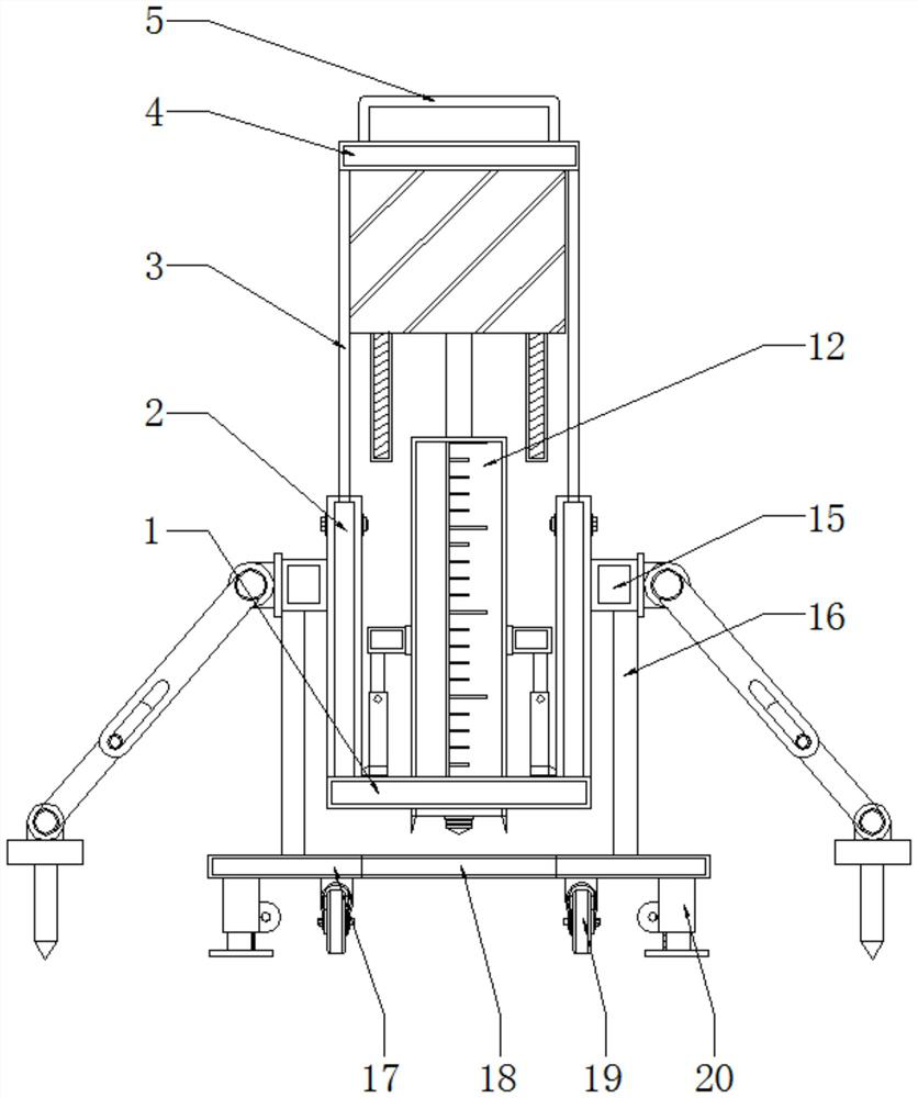
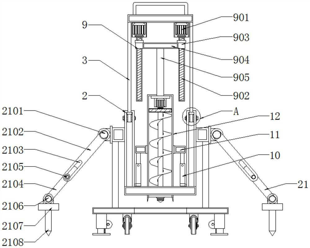
[0031] see Figure 1 to Figure 8, the present invention provides a technical solution: a data acquisition tool for surveying and mapping geographic information, including a base plate 1, a push assembly 9 and an acquisition assembly 14, side frames 2 are fixed on both sides above the base plate 1, and an upper frame is installed above the side frame 2 Plate 3, a top plate 4 is fixed on the top of the upper frame plate 3, and a handle 5 is fixed above the top plate 4, and the push assembly 9 is arranged below the top plate 4, and the push assembly 9 includes a servo motor 901, a screw rod 902, a threaded sleeve Tube 903, horizontal plate 904, push rod 905, rear connecting rod 906, limit slider 907 and limit chute 908, the underside of servo motor 901 is provided with screw mandrel 902, and the outer side of screw mandrel 902 is installed with threaded sleeve A horizontal plate 904 is fixed between the barrel 903 and the threaded sleeve 903, and a push rod 905 is fixed below the...


PUM


Abstract

The invention discloses a surveying and mapping geographic information data acquisition tool, and relates to the technical field of geographic information. The surveying and mapping geographic information data acquisition tool comprises a bottom plate, a pushing assembly and an acquisition assembly, side frames are fixed to the two sides of the upper portion of the bottom plate, an upper frame plate is installed above the side frames, a top plate is fixed to the top of the upper frame plate, and a handle is fixed to the upper portion of the top plate; and the pushing assembly is arranged below the top plate and comprises a servo motor, a lead screw, threaded sleeves, a transverse plate, a pushing rod, a rear connecting rod, a limiting sliding block and a limiting sliding groove, the lead screw is arranged on the lower side of the servo motor, the threaded sleeves are installed on the outer side of the lead screw, the transverse plate is fixed between the threaded sleeves, and the pushing rod is fixed below the transverse plate. According to the surveying and mapping geographic information data acquisition tool, the acquisition assembly can be pushed, soil can be automatically acquired through the acquisition assembly, the acquisition depth of the acquisition assembly is large, and in the using process, the tool can be suitable for different terrains and is high in stability.

Description

technical field [0001] The invention relates to the technical field of geographic information, in particular to a data collection tool for surveying and mapping geographic information. Background technique [0002] Geographical information is the geographical meaning contained and expressed by geographic data, and it is the general term for numbers, characters, images, and graphics related to the quantity, quality, nature, distribution characteristics, connections, and laws of substances related to geographic environmental elements. The shape, size, spatial location and attributes of geographical elements or surface artificial facilities are measured, collected and drawn into maps. In the process of surveying and mapping geographic information data, it is also necessary to collect soil information in order to obtain geographic information data such as soil attributes, so collection tools are required. [0003] Existing surveying and mapping geographic information data colle...

Claims


Application Information

Patent Timeline
Patent Type & Authority Applications(China)
IPC IPC(8): G01N1/08B08B1/00
CPCG01N1/08B08B1/002
Inventor 冯超帆张敏
Owner 冯超帆
Why Eureka
Try Eureka