Slope deformation monitoring method and system based on scanning total station and a GNSS
A technology of deformation monitoring and total station, which is applied in the field of geotechnical engineering, can solve problems such as the inability to monitor slope surface deformation with high precision, and achieve the effect of accurate surface monitoring
- Summary
- Abstract
- Description
- Claims
- Application Information
AI Technical Summary
Problems solved by technology
Method used
Image


Examples
Embodiment
[0043] The slope deformation monitoring method based on scanning total station and GNSS described in the embodiment of the present invention, such as figure 1 shown, including the following steps:
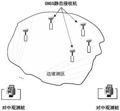
[0044] Step 1. Set a plurality of GNSS static receivers at the characteristic positions of the slope to be measured, and set a plurality of scanning position centering observation piles for scanning total stations within the sight range covering the slope to be measured;
[0045] Such as figure 2 As shown, firstly, it is necessary to embed several GNSS static observation receiver observation piers at the first distance D1 in the slope to be monitored, and the GNSS static observation receiver observation piers can also be encrypted and pre-embedded in areas that need to be focused on. Among them, the first distance D1 is determined depending on specific characteristics such as slope undulations, and it is recommended that D1 be no greater than 20m.
[0046] Then, within the line-...
PUM
 Abstract
Description
Claims
Application Information