A rock and soil layer drilling equipment for geological survey

A technology for geological survey and geotechnical layer, applied in the field of geotechnical layer drilling equipment, can solve the problems of large volume, time-consuming and labor-intensive, and increased labor intensity of staff.

Active Publication Date: 2022-03-29
山东省地质矿产勘查开发局八〇一水文地质工程地质大队
View PDF3 Cites 1 Cited by
  • Summary
  • Abstract
  • Description
  • Claims
  • Application Information

AI Technical Summary

Problems solved by technology

[0003] "Geological prospecting" is the discovery of mineral deposits with industrial significance in the general survey of mineral resources. In order to ascertain the quality and quantity of mineral products, as well as the technical conditions for mining and utilization, and provide the mineral reserves and geological data required for mine construction design, it is necessary to conduct a survey in a certain area. However, the existing rock-soil drilling equipment used for geological surveys is generally large in size and cannot effectively adjust the position according to the needs. It is inconvenient to move, and the waste rock and soil in the hole cannot be discharged in time and effectively after drilling. It is necessary to stop and use a soil discharge device to discharge the waste soil in the hole, which increases the labor intensity of the staff, takes time and effort, and cannot effectively treat Sampling the soil at different depths in the borehole leads to inaccurate detection results, so it is necessary to provide a rock-soil layer drilling equipment for geological surveys to solve the above problems

Method used


Image

  • A rock and soil layer drilling equipment for geological survey
  • A rock and soil layer drilling equipment for geological survey
  • A rock and soil layer drilling equipment for geological survey

Examples


Embodiment Construction

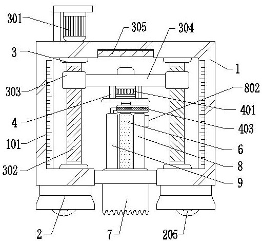
[0031] The embodiment of the present invention discloses a rock-soil layer drilling equipment for geological survey, such as Figure 1-7 shown, including:

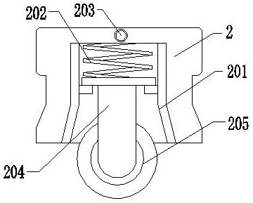
[0032] The main body of the support frame 1 has scale lines 101 on both sides of the front of the main body 1 of the support frame, fixed bases 2 are fixed on both sides of the lower surface of the main body of the support frame 1, and a depth adjustment component 3 is arranged inside the main body 1 of the support frame. The depth adjustment component 3 includes Servo motor 301, threaded rod 302, nut part 303 and No. 1 belt 305, threaded rod 302 and nut part 303 are all provided with two, two nut parts 303 are threadedly connected with two threaded rods 302 respectively, two nut parts 303 A mounting plate 304 is connected between them;

[0033] Simultaneously this device also comprises driving mechanism 4, and driving mechanism 4 is arranged on the lower end surface of mounting plate 304, and driving mechanism 4 comprise...


PUM


Abstract

The invention discloses a rock-soil layer drilling equipment for geological survey, which relates to the technical field of surveying. The rock-soil layer drilling equipment for geological survey includes a support frame main body and a driving mechanism, and a depth depth is set inside the support frame main body. The adjustment assembly, the depth adjustment assembly includes a servo motor, a threaded rod, a nut piece and a No. 1 belt, a mounting plate is connected between the two nut pieces, the driving mechanism includes a drive motor, a drive shaft and a protective box, and the lower end of the drive shaft passes through the protective box A rotating rod is fixedly arranged, and a cylindrical cutter is fixedly arranged at the lower end of the rotating rod, and a sampling mechanism is fixedly arranged on one side of the rotating rod on the surface of the upper end of the cylindrical cutter. The rock and soil produced by the hole are discharged in time, and the rock and soil at different depths are sampled at the same time.

Description

technical field [0001] The invention relates to the technical field of surveying, in particular to a rock-soil layer drilling equipment for geological surveying. Background technique [0002] "Geological prospecting" is the investigation and research activity of conducting geological exploration and detection through various means and methods, determining the appropriate bearing layer, determining the foundation type and calculating the foundation parameters according to the foundation bearing capacity of the bearing layer. [0003] "Geological prospecting" is the discovery of mineral deposits with industrial significance in the general survey of mineral resources. In order to ascertain the quality and quantity of mineral products, as well as the technical conditions for mining and utilization, and provide the mineral reserves and geological data required for mine construction design, it is necessary to conduct a survey in a certain area. However, the existing rock-soil dril...

Claims


Application Information

Patent Timeline
Patent Type & Authority Patents(China)
IPC IPC(8): E21B7/00E21B7/02E21B49/02E21B19/081B60B33/04
CPCE21B7/005E21B7/027E21B49/02E21B19/081B60B33/045
Inventor 刘同喆李哲刘小健张丽红陈亮邱晨
Owner 山东省地质矿产勘查开发局八〇一水文地质工程地质大队
Why Eureka
Try Eureka