Frequency domain method for inverting ocean gravity gradient by using satellite altimetry data

A technology of gravity gradient and data inversion, which is used in the measurement of gravitational fields, measurement devices, complex mathematical operations, etc. The effect of precision

Active Publication Date: 2022-02-25
CHINA UNIV OF GEOSCIENCES (BEIJING)
View PDF9 Cites 0 Cited by
  • Summary
  • Abstract
  • Description
  • Claims
  • Application Information

AI Technical Summary

Problems solved by technology

[0005] The present invention mainly provides a frequency-domain method for retrieving ocean gravity gradients using satellite altimetry data, to solve the problems in the above background technology t

Method used


Image

  • Frequency domain method for inverting ocean gravity gradient by using satellite altimetry data
  • Frequency domain method for inverting ocean gravity gradient by using satellite altimetry data
  • Frequency domain method for inverting ocean gravity gradient by using satellite altimetry data

Examples


Embodiment Construction

[0022] In order to enable those skilled in the art to better understand the present invention, the technical solutions in the embodiments of the present invention will be clearly and completely described below in conjunction with the drawings in the embodiments of the present invention.

[0023] The present invention mainly provides a frequency-domain method for retrieving the ocean gravity gradient using satellite altimetry data, which is used to solve the problem that it is difficult to obtain the full tensor gravity gradient from the satellite altimetry data and cannot accurately invert the ocean full tensor gravity gradient question.

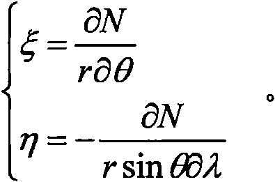
[0024] The frequency domain method for retrieving the ocean gravity gradient based on satellite altimetry data includes the following steps: (1) Calculate the north-south vertical deviation ξ and the east-west vertical deviation η according to the altimetry satellite data, and the expressions are as follows:

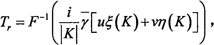
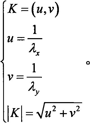
[0025] (2) The radial disturb...


PUM


Abstract

The invention provides a frequency domain method for inverting an ocean gravity gradient by using satellite altimetry data. The method comprises the steps of (1) calculating to obtain south-north vertical line deviation and east-west vertical line deviation according to altimetry satellite data; (2) obtaining radial disturbance gravity anomaly by means of the vertical line deviation derived from the altimetry satellite data, and calculating disturbance gravity anomaly in other directions by means of the south-north vertical line deviation and the east-west vertical line deviation; (3) carrying out Fourier transform calculation on the obtained disturbance gravity anomaly so as to obtain a Fourier transform calculation value of the disturbance gravity gradient in each direction under a spherical coordinate system; and (4) calculating the full-tensor gravity gradient through the Fourier transform calculation value of the disturbance gravity gradient. According to the invention, the full-tensor gravity gradient can be calculated according to the satellite altimetry data.

Description

technical field [0001] The invention mainly relates to the technical field of satellite gravity gradient inversion, in particular to a spectrum method for inversion of ocean gravity gradient from satellite altimetry data. Background technique [0002] Altimetry satellites play an important role in earth science, and ocean gravity field is one of its main products. Some research institutes and universities have published multiple versions of high-precision ocean gravity field products. However, the main type of altimetry satellite gravity field products are gravity anomalies. In fact, altimetry satellite observations can also be used to derive gravity gradient products, which is very beneficial to earth sciences, such as the study of the earth's internal structure, seafloor topography inversion, and underwater navigation. [0003] Compared with the inversion results of gravity anomalies, the results of inversion of ocean gravity gradient using altimetry data are relatively ...

Claims


Application Information

Patent Timeline
IPC IPC(8): G01V7/06G06F17/14
CPCG01V7/06G06F17/14Y02A90/10
Inventor 万晓云金湘博
Owner CHINA UNIV OF GEOSCIENCES (BEIJING)
Why Eureka
Try Eureka