Unmanned aerial vehicle route planning method and device and computer equipment

A technology of drones and routes, applied in three-dimensional position/course control, vehicle position/route/height control, non-electric variable control, etc., can solve the problem that drones cannot choose a more suitable route, and achieve obstacle avoidance problem effect

Pending Publication Date: 2022-03-11
SHENZHEN URBAN PUBLIC SAFETY & TECH INST CO LTD
View PDF0 Cites 0 Cited by
  • Summary
  • Abstract
  • Description
  • Claims
  • Application Information

AI Technical Summary

Problems solved by technology

[0004] Therefore, the technical problem to be solved by the present invention is to overcome the defect that the UAV in the prior art only hovers or returns when it encounters an obstacle, so that the UAV cannot choose a more suitable route, thereby providing a UAV Route planning method, device and computer equipment

Method used


Image

  • Unmanned aerial vehicle route planning method and device and computer equipment
  • Unmanned aerial vehicle route planning method and device and computer equipment
  • Unmanned aerial vehicle route planning method and device and computer equipment

Examples


Embodiment Construction

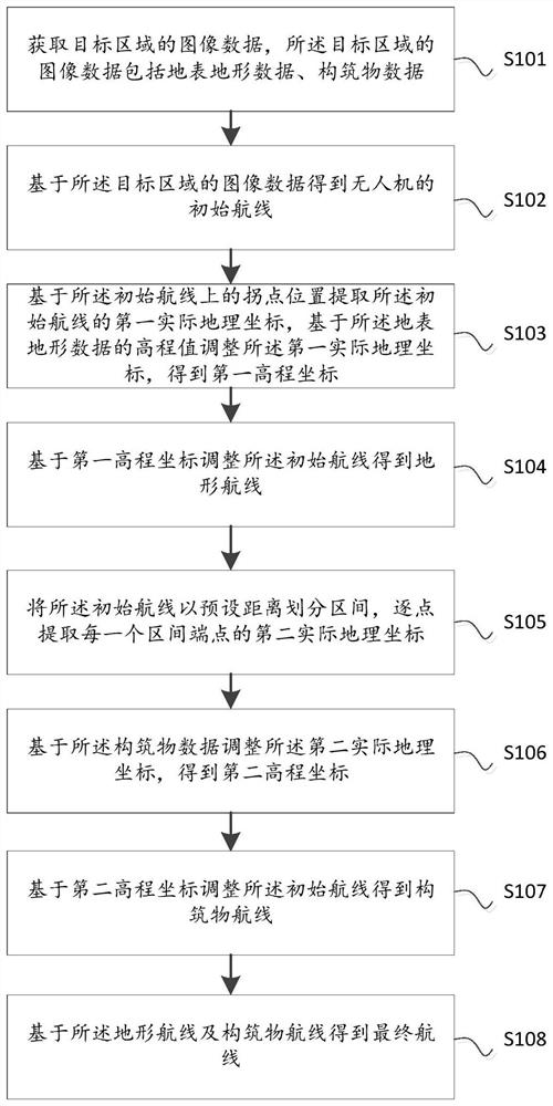
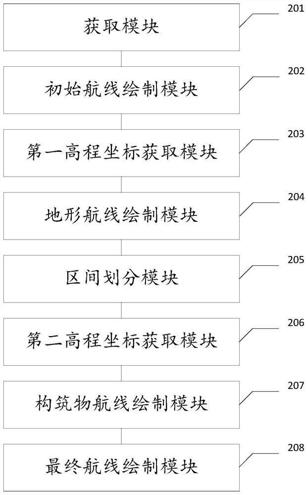
[0022] The technical solutions of the present invention will be clearly and completely described below in conjunction with the accompanying drawings. Apparently, the described embodiments are some of the embodiments of the present invention, but not all of them. Based on the embodiments of the present invention, all other embodiments obtained by persons of ordinary skill in the art without making creative efforts belong to the protection scope of the present invention.

[0023] In the description of the present invention, it should be noted that the terms "center", "upper", "lower", "left", "right", "vertical", "horizontal", "inner", "outer" etc. The indicated orientation or positional relationship is based on the orientation or positional relationship shown in the drawings, and is only for the convenience of describing the present invention and simplifying the description, rather than indicating or implying that the referred device or element must have a specific orientation, ...


PUM


Abstract

The invention discloses an unmanned aerial vehicle route planning method and device and computer equipment, and the method comprises the steps: obtaining image data of a target region, the image data of the target region comprising surface topographic data and structure data; obtaining an initial route of the unmanned aerial vehicle based on the image data of the target area; extracting a first actual geographic coordinate of the initial route based on the inflection point position on the initial route, and adjusting the first actual geographic coordinate based on the elevation value of the surface topographic data to obtain a first elevation coordinate; adjusting the initial route based on the first elevation coordinate to obtain a terrain route; dividing the initial route into intervals according to a preset distance, and extracting a second actual geographic coordinate of an end point of each interval point by point; adjusting the second actual geographic coordinate based on the structure data to obtain a second elevation coordinate; adjusting the initial route based on the second elevation coordinate to obtain a structure route; and obtaining a final route based on the terrain route and the structure route.

Description

technical field [0001] The invention relates to the technical field of UAV route planning, in particular to a UAV route planning method, device and computer equipment. Background technique [0002] UAVs have more and more application scenarios. In the process of natural disaster risk survey, it is necessary to collect massive data of disaster-affected bodies on-site, and collect photos, videos and other related information of disaster-affected bodies. Among them, the data acquisition and obstacle avoidance of drones in densely built areas is a key research issue. The image data collection of natural disaster target areas has the characteristics of relatively simple and unified data specifications. Real-time positioning and collection of photos of disaster-affected bodies is a professional application scenario for UAVs. [0003] Most of the existing data collection UAV line inspection and obstacle avoidance methods use laser radar, ultrasonic and other methods. The cost of U...

Claims


Application Information

Patent Timeline
IPC IPC(8): G05D1/10
CPCG05D1/101
Inventor 张希修文群齐文光李兰勇
Owner SHENZHEN URBAN PUBLIC SAFETY & TECH INST CO LTD
Why Eureka
Try Eureka