Unmanned aerial vehicle obstacle avoidance controlling method

A control method and unmanned aerial vehicle technology, applied in three-dimensional position/channel control, etc., to achieve good environmental adaptability, simple method, and improved safety

Inactive Publication Date: 2015-06-17
NANJING UNIV OF AERONAUTICS & ASTRONAUTICS
View PDF6 Cites 0 Cited by
  • Summary
  • Abstract
  • Description
  • Claims
  • Application Information

AI Technical Summary

Problems solved by technology

[0008] To sum up, the existing UAV obstacle avoidance method is not very effective for UAV low-altitude operation, and there are still many practical problems to be solved.

Method used


Image

  • Unmanned aerial vehicle obstacle avoidance controlling method
  • Unmanned aerial vehicle obstacle avoidance controlling method
  • Unmanned aerial vehicle obstacle avoidance controlling method

Examples


Embodiment 1

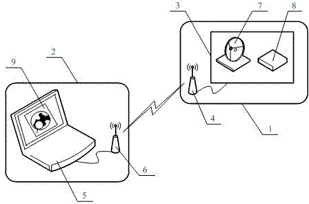
[0042] Example 1: Such as figure 1 , UAV obstacle avoidance control system based on columnar space planning constraints, with UAV subsystem 1 and ground station subsystem 2; UAV subsystem 1 includes embedded flight controller 3 and airborne terminal 4 of wireless data link , The embedded flight controller 3 has a built-in satellite positioning receiver 7 and an altitude sensor 8; the ground station subsystem 2 includes an embedded monitoring computer 5 and the ground terminal 6 of the wireless data link, and the embedded monitoring computer 5 has a built-in computer that contains obstacle geographic information Electronically Picture 9 ; The embedded flight controller 3 is connected with the airborne terminal 4 of the wireless data link through a serial bus, the embedded monitoring computer 5 is connected with the ground terminal 6 of the wireless data link through a serial bus, and the airborne terminal 4 of the wireless data link is connected with The ground end 6 of the wire...

Embodiment 2

[0051] Example 2: Such as Figure 4 As shown, for an obstacle with an arc-shaped boundary, N straight line segments are used to surround the two-dimensional geographic boundary of the obstacle to form a closed boundary contour line 14, as follows:

[0052] ① The operator in the built-in two-dimensional ground of the monitoring computer 5 Picture 9 Manual operation above, for the straight line boundary, directly take the straight line segment corresponding to the boundary;

[0053] ② For the convex arc boundary, select multiple characteristic points on the arc boundary including the starting and ending points of the arc boundary. The number and position of the points are selected by the ground operator according to the size of the arc. Generally, the number of points ≥ 3. The positions are evenly distributed, and the greater the radian, the more points; this embodiment takes 5 characteristic points, namely X 1 ~X 5 ; Draw arc-shaped tangents along each characteristic point, and two ...

Embodiment 3

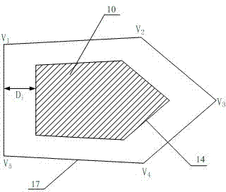
[0057] Example 3: Such as Figure 5 As shown, for an annular obstacle, obstacle avoidance boundaries are respectively set on the outer boundary and the inner boundary of the annular obstacle. Figure 5 The middle 10 is the obstacle, 15 is the inner boundary contour, 16 is the outer boundary contour, and the obstacle avoidance boundary 19 of the outer boundary is set in the same way as in the first and second embodiments. V 1 ~V 16 Is the vertex.

[0058] The method for determining the obstacle avoidance boundary of the inner boundary is as follows: for the straight line boundary, directly take the straight line segment corresponding to the boundary; for the convex arc boundary, select multiple arc boundaries including the start and end points of the arc boundary The feature points, the number of points, and the location are selected by the ground operator according to the radian. In general, the number of points is ≥3, and the location is evenly distributed. The larger the arc, the...


PUM


Abstract

The invention discloses an unmanned aerial vehicle obstacle avoidance controlling method. An unmanned aerial vehicle subsystem and a ground station subsystem are arranged, the unmanned aerial vehicle subsystem comprises an embedded flight controller and an airborne terminal of a wireless data chain, a satellite positioning receiver and a height sensor are arranged in the embedded flight controller, the ground subsystem comprises an embedded monitoring computer and a ground terminal of the wireless data chain, and an electronic map containing geographic information of obstacles is arranged in the embedded monitoring computer. On the electronic map in the embedded monitoring computer of the ground station subsystem, the geographic information of the obstacles in a flight area is determined, virtual obstacle polygonal cylinders are established, shape data of the virtual obstacle polygonal cylinders are downloaded in the embedded flight controller which obtains the current position of the unmanned aerial vehicle and calculates space correlation between the unmanned aerial vehicle and the obstacle polygonal cylinders, track-shifting instruction of the unmanned aerial vehicle is generated, and automatic obstacle avoidance of the unmanned aerial vehicle is realized.

Description

Technical field [0001] The invention belongs to the technical field of unmanned aerial vehicle control, and specifically relates to a UAV obstacle avoidance control method, which can be widely used in aerial photography, power inspection, environmental monitoring, forest fire prevention, disaster inspection, terrorism and lifesaving, military reconnaissance, and battlefields. Evaluation and other fields. Background technique [0002] The research of UAV control technology is currently one of the hotspots of domestic and foreign universities and research institutions. In the past ten years, UAVs have been widely used in aerial photography, power inspections, environmental monitoring, forest fire prevention, disaster inspections, terrorism and life-saving, military reconnaissance, battlefield assessment and other fields, effectively overcoming the problems of manned aircraft aerial operations. Insufficient, reduce the cost of purchase and maintenance, and improve the safety of the...

Claims


Application Information

Patent Timeline
Patent Type & Authority Patents(China)
IPC IPC(8): G05D1/10
Inventor 杨忠李少斌谢婷婷徐华东王世勇黄宵宁杨轻杨成顺梁焜陈阳
Owner NANJING UNIV OF AERONAUTICS & ASTRONAUTICS
Why Eureka
Try Eureka