Three-dimensional map scene building method based on various data

A three-dimensional map and scene technology, applied in the field of three-dimensional map scene construction, can solve problems such as inability to visualize data

Pending Publication Date: 2022-03-11
SHANGHAI ADVANCED AVIONICS
View PDF0 Cites 6 Cited by
  • Summary
  • Abstract
  • Description
  • Claims
  • Application Information

AI Technical Summary

Problems solved by technology

However, the traditional two-dimensional map, due to its planar feature, can only mark the data in a limited two-dimensional plane but cannot visualize the data, and cannot provide users with a better simulation experience based on real scenes

Method used


Image

  • Three-dimensional map scene building method based on various data
  • Three-dimensional map scene building method based on various data
  • Three-dimensional map scene building method based on various data

Examples


Embodiment Construction

[0022] The present invention will be further described below in conjunction with the accompanying drawings and embodiments.

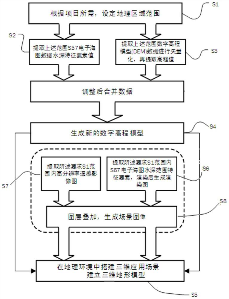
[0023] figure 1 It is a schematic structural diagram of a method for building a three-dimensional map scene based on various data in an embodiment of the present invention.

[0024] See figure 1 , the method for building a three-dimensional map scene based on various data in the embodiment of the present invention includes the following steps:

[0025] Step S1: Set the scope of the geographical area according to the scene construction requirements, and create a vector file of the geographical area;

[0026] Step S2: Obtain the electronic chart containing the geographical area in step S1, process the electronic chart, obtain the value of the water depth characteristic element, and generate a vector point element file based on the water depth characteristic element value; the specific steps are as follows:

[0027] S21: Obtain the water depth feature e...


PUM


Abstract

The invention discloses a three-dimensional map scene building method based on various data. The method comprises the steps that a geographic area range is set according to scene building requirements; the method comprises the following steps: acquiring an electronic chart of a geographic area range, acquiring a water depth characteristic element value for the electronic chart, and generating a vector point element file based on the water depth characteristic element value; acquiring a digital elevation model of a geographic area range, processing the digital elevation model, and generating a vector point element file based on an elevation value; adjusting the coordinate system of the generated vector point element file, combining to generate a new vector point element file, and generating a combined digital elevation model; and establishing a three-dimensional scene and/or three-dimensional terrain model according to the combined digital elevation model. According to the invention, a sea-land integrated three-dimensional effect is rapidly realized, and meanwhile, rendering effects in different water depth ranges are realized according to water depth values; the three-dimensional scene simulation module is placed in a map application engine to achieve three-dimensional scene simulation tending to a real terrain; and meanwhile, a three-dimensional terrain model based on real landform features is generated.

Description

technical field [0001] The invention relates to a method for building a three-dimensional map scene, in particular to a method for building a three-dimensional map scene based on various data. Background technique [0002] With the growth of the shipping industry and related industries and the development trend of the map industry, future maps will develop vigorously from two-dimensional planes to three-dimensional three-dimensional trends, and there will be more and more map-using industries including the shipping industry and related industries. Use a 3D map as a reference. However, the traditional two-dimensional map, due to its planar feature, can only mark the data in a limited two-dimensional plane but cannot visualize the data, and cannot provide users with a better simulation experience based on real scenes . [0003] The 3D map can add a three-dimensional effect on the basis of the 2D map. Most of the existing 3D elevation data models (DEM) only include ground ele...

Claims


Application Information

Patent Timeline
Patent Type & Authority Applications(China)
IPC IPC(8): G06T17/05G06T15/00G06T15/04
CPCG06T17/05G06T15/005G06T15/04
Inventor 乔慧桢
Owner SHANGHAI ADVANCED AVIONICS
Why Eureka
Try Eureka