High-resolution remote sensing road extraction method based on deep learning and multi-dimensional attention

A high-resolution, road extraction technology, applied in the field of remote sensing image processing, to achieve the effect of improved accuracy and strong feature expression ability

Pending Publication Date: 2022-03-11
张男
View PDF0 Cites 0 Cited by
  • Summary
  • Abstract
  • Description
  • Claims
  • Application Information

AI Technical Summary

Problems solved by technology

[0005] The purpose of the present invention is to provide a road extraction method for high-resolution remote sensing images based on the combination of deep learning network and multi-dimensional attention mechanism. problem with road information

Method used


Image

  • High-resolution remote sensing road extraction method based on deep learning and multi-dimensional attention
  • High-resolution remote sensing road extraction method based on deep learning and multi-dimensional attention
  • High-resolution remote sensing road extraction method based on deep learning and multi-dimensional attention

Examples


Embodiment Construction

[0047] The present invention will be further described below in conjunction with the accompanying drawings and embodiments.

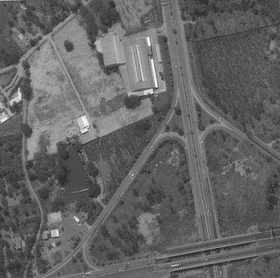
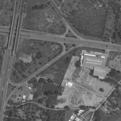
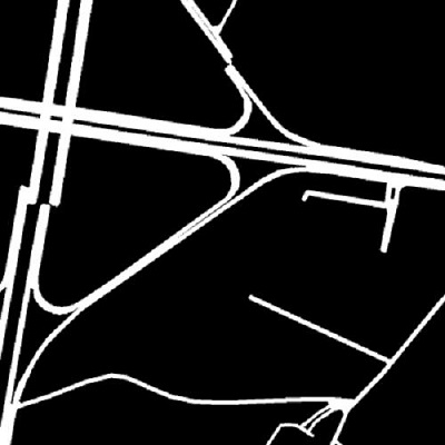
[0048] Such as figure 1 As shown, a high-resolution remote sensing image road extraction method based on the combination of deep learning network and multi-dimensional attention mechanism, including (S1)~(S6) six steps.

[0049] (S1) Constructing a data set: scientifically select a certain number of labeled high-resolution remote sensing images, and divide them into training data sets, verification data sets and test data sets; use data enhancement methods to pre-process the data sets to avoid excessive training during training. Fitting happens.

[0050] The present invention selects the high-precision remote sensing images of DeepGlobe, wherein the training data set includes 6626 high-precision remote sensing images and 6626 labels, the training set includes 1243 images, and the test set includes 1101 images, all of which are 1024x1024 in size. The D...


PUM


Abstract

The invention discloses a high-resolution remote sensing image road extraction method based on combination of deep learning and a multi-dimensional attention mechanism. The method comprises the following steps: extracting remote sensing image road information by adopting a full convolutional neural network UNet; a multi-dimensional attention module is combined with a coding part of the UNet network, so that a road feature map transmitted to a decoding part has higher feature expression capability; a multi-level feature fusion mode is adopted, feature information of different levels is obtained in each layer in the decoding stage, and a transmitted feature map has texture information and semantic information so as to optimize the expression ability of the feature map; a user can observe an extraction result of a high-resolution remote sensing image returned by a satellite in real time by accessing a Web front end of node.js based on a server. According to the scheme, high-accuracy remote sensing image road information is extracted, the image subjected to convolution training has higher expression ability due to introduction of the multi-dimensional attention module and the multi-level feature fusion method, and compared with a general deep learning method, the remote sensing image road extraction accuracy is improved. Meanwhile, the self-feedback mechanism of the deep learning network enables the extraction process to be more intelligent and automatic, and adaptive adjustment can be performed on images of different road scales in different regions to obtain optimal road image information, so that the method has very high practical value and popularization value.

Description

technical field [0001] The invention belongs to the technical field of remote sensing image processing, and in particular relates to a deep learning-based high-resolution remote sensing image road extraction technology, which mainly combines a multi-dimensional attention mechanism and a multi-level feature fusion method. Background technique [0002] In recent years, the application of remote sensing big data has gradually expanded. The wide coverage and high accuracy of high-resolution imagery make it an important source of geographic information data. The road network information extracted from these images will have a wide range of applications in navigation, cartography, urban planning, and geological inspection. Road is an important artificial feature and subject of modern transportation facilities, and it is also the basic data of geographic information system. Therefore, updating road information in time is of great significance to the work such as mapping, route an...

Claims


Application Information

Patent Timeline
Patent Type & Authority Applications(China)
IPC IPC(8): G06V20/10G06V10/774G06V10/80G06V10/82G06N3/04G06N3/08
CPCG06N3/08G06N3/048G06N3/045G06F18/214G06F18/253
Inventor 张男黄鑫杨艾青
Owner 张男
Why Eureka
Try Eureka