
Surveying and mapping unmanned aerial vehicle and surveying and mapping method thereof

A technology of drones and airframes, applied in the field of drone surveying and mapping, can solve the problems of dust contamination on the lens, blurring of the surveying and mapping lens, and difficulty in guaranteeing, and achieve the effect of avoiding dust contamination

Pending Publication Date: 2022-03-25
呼和浩特市自然资源规划设计研究有限公司
View PDF0 Cites 0 Cited by
  • Summary
  • Abstract
  • Description
  • Claims
  • Application Information

AI Technical Summary

Problems solved by technology

[0003] Since the inclination angle of the cameras on both sides is about 45 degrees, if it rains during surveying and mapping, the cameras on both sides will be stained with rainwater, and the surveying and mapping lenses will be blurred by the rain, resulting in blurred topographic maps with errors. The focal length is determined. Shooting at a certain height can ensure that the proportions of the photos are consistent. However, the UAV will fly higher or lower than the set height when it is blown by strong winds. It is difficult for the UAV to quickly adjust the height. Reverting back to the original place will cause the scale of the survey map taken at this time to change, and it is difficult to stitch the photos taken; when the drone lands, it is difficult to ensure that the landing ground is flat, and if there are stones on the ground, it will cause It collides with the lens and causes damage, and dust will be blown up when the drone lands, causing the lens to be contaminated with dust, which is not conducive to the next surveying and mapping. Therefore, we propose a surveying and mapping drone and its surveying method

Method used


Image

  • Surveying and mapping unmanned aerial vehicle and surveying and mapping method thereof
  • Surveying and mapping unmanned aerial vehicle and surveying and mapping method thereof
  • Surveying and mapping unmanned aerial vehicle and surveying and mapping method thereof

Examples


Embodiment 1

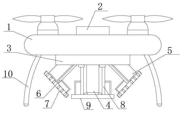
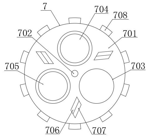
[0036] like figure 1 , 2 , 3 and 6, a surveying and mapping unmanned aerial vehicle comprises a body 1, a central control module 2 is fixedly installed on the top of the body 1, an installation platform 3 and a landing gear 10 are fixedly connected to the bottom of the body 1, and the bottom of the installation platform 3 is fixedly connected. The main camera 4 and the side camera 5 are fixedly installed, the lens of the main camera 4 faces directly downward, the lenses of the two side cameras 5 are respectively inclined to both sides, and the lower end surfaces of the main camera 4 and the side camera 5 are respectively provided with a first auxiliary surveying and mapping. The mechanism 7 and the second auxiliary surveying and mapping mechanism 9 and the two landing gears 10 are located on both sides of the installation platform 3 respectively.

[0037] The first auxiliary surveying and mapping mechanism 7 includes a first turntable 701 , a rotation hole 702 is opened at th...

Embodiment 2

[0043] like Figure 1-7 As shown, a surveying and mapping drone includes a body 1, a central control module 2 is fixedly installed on the top of the body 1, a mounting platform 3 and a landing gear 10 are fixedly connected to the bottom of the body 1, and a main For the camera 4 and the side camera 5, the lens of the main camera 4 faces directly downward, the lenses of the two side cameras 5 are respectively inclined to both sides, and the lower end surfaces of the main camera 4 and the side camera 5 are respectively provided with a first auxiliary surveying and mapping mechanism 7 and a Two auxiliary surveying and mapping mechanisms 9 and two landing gears 10 are located on both sides of the installation platform 3 respectively.

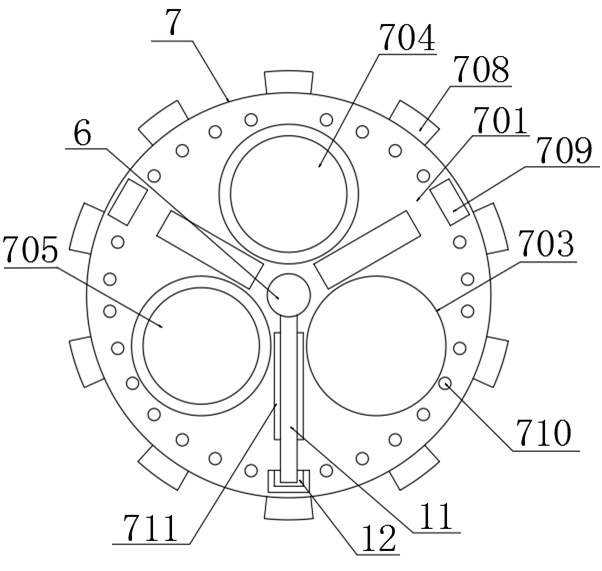
[0044] The first auxiliary surveying and mapping mechanism 7 includes a first turntable 701 , a rotation hole 702 is opened at the center of the first turntable 701 , and a first installation rod 6 is rotatably connected to the inside of the rotatio...


PUM


Abstract

The surveying and mapping unmanned aerial vehicle comprises a vehicle body, a central control module is fixedly mounted at the top of the vehicle body, a mounting platform and an undercarriage are fixedly connected to the bottom of the vehicle body, a main camera and a side camera are fixedly mounted at the bottom of the mounting platform, a lens of the main camera faces the right lower portion, and a lens of the side camera faces the right lower portion. Lenses of the two side cameras incline towards the two sides respectively, and the lower end faces of the main camera and the side cameras are provided with a first auxiliary surveying and mapping mechanism and a second auxiliary surveying and mapping mechanism respectively. Through cooperation of the first auxiliary surveying and mapping mechanism and the second auxiliary surveying and mapping mechanism, lenses of the main camera and the side camera can be wiped clean when the lenses of the main camera and the side camera are contaminated by rainwater or dust, and the proportion of shot surveying and mapping photos can be ensured to be consistent under the condition of strong wind.

Description

technical field [0001] The invention relates to the technical field of drone surveying and mapping, in particular to a surveying and mapping drone and a surveying and mapping method. Background technique [0002] After a geological disaster occurs, it will cause serious damage to the traffic and communication in the disaster area, making it difficult for rescuers to enter the disaster area at the first time. The disaster situation in the disaster area, especially the information related to geospatial information, cannot be transmitted to the rescue command and decision-making. In the hands of personnel, oblique photography technology can be used to obtain accurate, intuitive, comprehensive and multi-angle topographic maps of disaster areas in time. Oblique images refer to the images obtained by aerial cameras with a certain oblique angle. At the same time, it collects images of ground targets from different angles such as vertical and inclined. In the same flight zone, the i...

Claims


Application Information

Patent Timeline
Patent Type & Authority Applications(China)
IPC IPC(8): B64C39/02B64D47/08B64D45/00B64C25/58B08B1/00
CPCB64C39/02B64D47/08B64D45/00B64C25/58B64U2101/30B08B1/143
Inventor 贾越鑫范向东董逸玮车政瑞尚雪松
Owner 呼和浩特市自然资源规划设计研究有限公司
Learn More