
Urban underground space intelligent surveying and mapping method and system

An underground space and intelligent technology, applied in the computer field, can solve problems such as difficulty in identifying unknown targets and poor experience, and achieve the effects of convenient and intuitive viewing, rich data resources, convenient and accurate implementation

Inactive Publication Date: 2022-04-01
李勇锋
View PDF0 Cites 0 Cited by
  • Summary
  • Abstract
  • Description
  • Claims
  • Application Information

AI Technical Summary

Problems solved by technology

[0003] Surveying and mapping of urban underground space is a huge and very important project, such as surveying the intersection of oil channels in underground space, distribution of water pipes, distribution of parking lots, etc. It is difficult to determine the existing underground space during surveying and mapping. The target object (object) in the survey area has a poor viewing experience after the survey

Method used


Image

  • Urban underground space intelligent surveying and mapping method and system
  • Urban underground space intelligent surveying and mapping method and system
  • Urban underground space intelligent surveying and mapping method and system

Examples


Embodiment Construction

[0044] In order to make the object, technical solution and advantages of the present invention clearer, the present invention will be further described in detail below in conjunction with the accompanying drawings and embodiments. It should be understood that the specific embodiments described here are only used to explain the present invention, not to limit the present invention.

[0045] The specific implementation of the present invention will be described in detail below in conjunction with specific embodiments.

[0046] The invention provides a method and system for intelligent surveying and mapping of urban underground space, which solves the problems raised in the background technology.

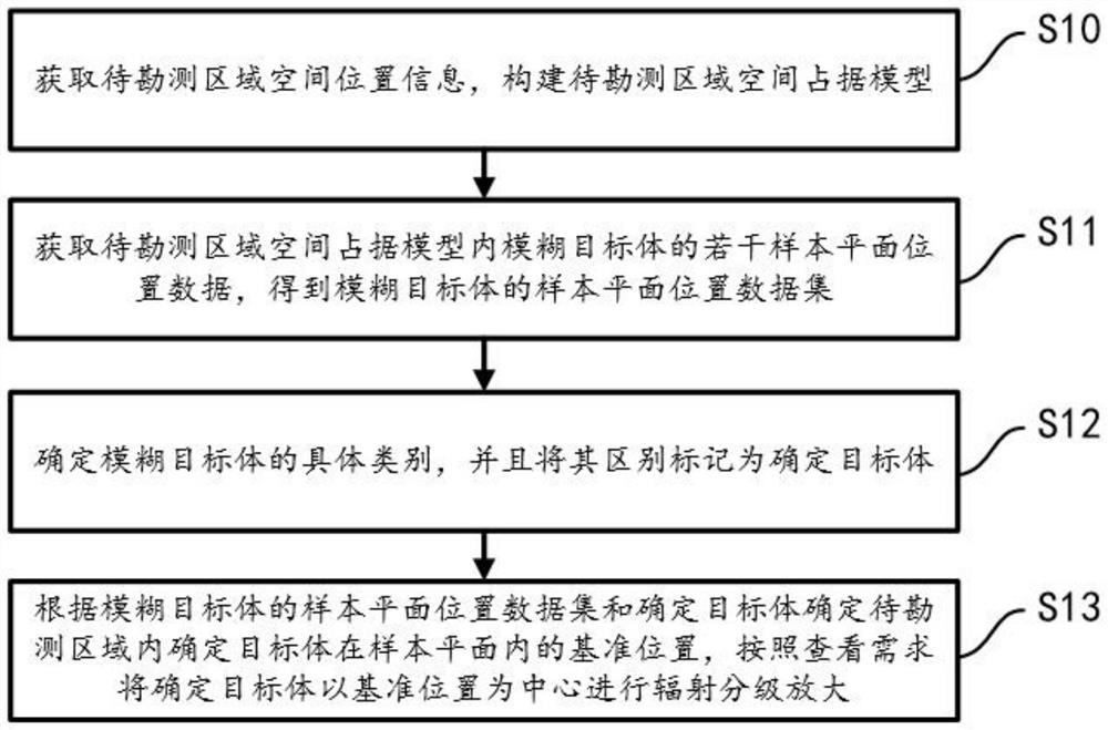
[0047] Such as figure 1 Shown, described a kind of urban underground space intelligent survey surveying and mapping method comprises:

[0048] Step S10: Obtain the spatial position information of the area to be surveyed, and construct a space occupancy model of the area to be surveye...


PUM


Abstract

The invention is suitable for the field of computers, and provides an urban underground space intelligent surveying and mapping method and system, and the method comprises the following steps: obtaining the spatial position information of a to-be-surveyed region, and constructing a to-be-surveyed region space occupation model; obtaining a plurality of sample plane position data of the fuzzy target body in the model occupied by the area space to be surveyed, and obtaining a sample plane position data set of the fuzzy target body; determining the specific category of the fuzzy target body, and marking the fuzzy target body as a determined target body; according to the sample plane position data set of the fuzzy target body and the determined target body, determining a reference position of the determined target body in a sample plane in a to-be-surveyed area, and performing radiation grading amplification on the determined target body by taking the reference position as a center according to a viewing demand; the method has the beneficial effects that not only can the accurate survey of the occupied position of the complex underground space be completed, but also the category of the target body in the underground space can be determined, and the accurate position survey and division of the target body can be completed.

Description

technical field [0001] The invention belongs to the field of computer technology, in particular to a method and system for intelligent surveying and mapping of urban underground space. Background technique [0002] In recent years, with the continuous and rapid development of China's economy and the improvement of urbanization level, the development and utilization of underground space in Chinese cities has been greatly developed. Underground space is mainly a term for architecture. It has a wide range, such as underground shopping malls, Underground parking lots, subways, mines, military, sea-crossing tunnels and other architectural spaces, the development of modern cities is a three-dimensional process of "going up to the ground". The development and utilization of urban underground spaces has become a hot spot, and the development of urban underground space facilities Safe operation is related to the normal production and life of the people. [0003] The survey and mappi...

Claims


Application Information

Patent Timeline
Patent Type & Authority Applications(China)
IPC IPC(8): G01C15/00G06F17/11G06Q50/26
Inventor 李勇锋陈西雨顾德乐李阳钱艺升
Owner 李勇锋
Learn More