Method and system for acquiring GNSS satellite inter-frequency deviation based on LEO

A technology of inter-frequency deviation and inter-frequency deviation, applied in the field of obtaining GNSS satellite inter-frequency deviation based on LEO, can solve the problems such as the difficulty of accurate quantification of the ionospheric model, the influence of the accuracy of the estimation of the inter-frequency deviation, and the complex ionospheric delay variation, etc. Achieve the effect of short observation time, strong real-time performance and fast movement speed

Pending Publication Date: 2022-04-05
重庆两江卫星移动通信有限公司
View PDF0 Cites 0 Cited by
  • Summary
  • Abstract
  • Description
  • Claims
  • Application Information

AI Technical Summary

Problems solved by technology

[0005] The technical problem to be solved by the present invention is that the existing GNSS satellite inter-frequency bias estimation requires longer time for regional observation and the ionospheric delay changes are complicated. The ionospheric model is not easy to quantify accurately, which will affect the accuracy of inter-frequency bias estimation. The problem of impact, the purpose is to provide a method and system for obtaining GNSS satellite inter-frequency deviation based on LEO, to solve the above problems

Method used


Image

  • Method and system for acquiring GNSS satellite inter-frequency deviation based on LEO
  • Method and system for acquiring GNSS satellite inter-frequency deviation based on LEO
  • Method and system for acquiring GNSS satellite inter-frequency deviation based on LEO

Examples


Embodiment 1

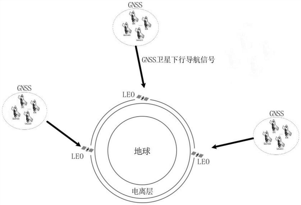
[0065] In Example 1, a single LEO is used for observation and distance description. like Figure 4 shown, including the following steps:

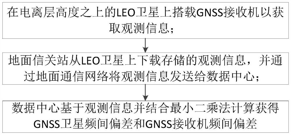
[0066] Onboard GNSS receivers on a single LEO satellite above the ionosphere;

[0067] The spaceborne GNSS receiver stores observation information in real time, and the observation information includes receiver position, pseudorange, C0, GNSS satellite ephemeris, and elevation angle;

[0068] The ground gateway station downloads the stored observation information from the LEO satellite, and sends the observation information to the data center through the ground communication network;

[0069] Based on the observation information and combined with the least square method, the data center calculates the GNSS satellite inter-frequency bias and the GNSS receiver inter-frequency bias.

[0070] Preferably, the data center calculates and obtains the GNSS satellite inter-frequency deviation and the GNSS receiver inter-frequency deviation based o...

Embodiment 2

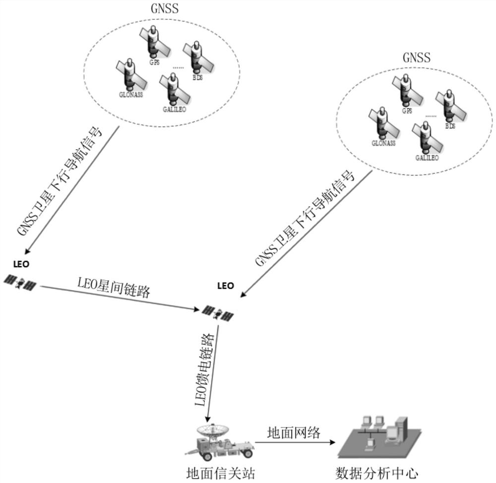
[0108] In Example 2, N LEOs are used for observation and distance description, where N is an integer greater than 1, such as Figure 5 shown, including the following steps:

[0109] A method for obtaining GNSS satellite inter-frequency deviation based on LEO, such as Figure 5 shown, including the following steps:

[0110] Each LEO satellite above the ionosphere is equipped with an on-board GNSS receiver;

[0111] Spaceborne GNSS receiver stores observation information in real time;

[0112] The overseas LEO satellites send the stored observation information to the domestic LEO satellites through the LEO inter-satellite link for summary to obtain the summary observation information;

[0113] The ground gateway station downloads the summary observation information from the LEO satellites in the territory, and sends the summary observation information to the data center through the ground communication network;

[0114] The data center calculates the inter-frequency deviatio...


PUM


Abstract

The invention discloses a method and a system for acquiring GNSS satellite inter-frequency deviation based on LEO. The method comprises the following steps: carrying a GNSS receiver on an LEO satellite above the height of an ionized layer to acquire observation information; the ground gateway station downloads the stored observation information from the LEO satellite and sends the observation information to the data center through a ground communication network; and the data center calculates and obtains the GNSS satellite inter-frequency deviation and the GNSS receiver inter-frequency deviation based on the observation information in combination with a least square method. According to the method, the GNSS receiver is carried on the LEO satellite above the height of the ionosphere, the GNSS observation value is not influenced by the ionosphere, the ionosphere does not need to be modeled when the GNSS satellite inter-frequency deviation and the GNSS receiver inter-frequency deviation are solved, and the solving error caused by the fact that the ionosphere model is difficult to quantify accurately is eliminated.

Description

technical field [0001] The invention relates to the field of satellite navigation, in particular to a method and a system for acquiring GNSS satellite inter-frequency deviation based on LEO. Background technique [0002] Global Navigation Satellite System (GNSS), also known as Global Navigation Satellite System (GNSS), is a space-based radio navigation and positioning system that can provide users with all-weather three-dimensional coordinates, speed, and time information anywhere on the earth's surface or near-Earth space. As an important part of the earth's space atmosphere, the ionosphere has a serious impact on radio navigation signals, and has become one of the most difficult sources of error in global navigation satellite system (GNSS) data processing. [0003] The existing GNSS satellite inter-frequency bias estimation generally adopts the method of continuous observation by ground monitoring stations. In order to ensure that all satellites in the constellation are ob...

Claims


Application Information

Patent Timeline
Patent Type & Authority Applications(China)
IPC IPC(8): G01S19/42G01S19/07
Inventor 陈建国杜江邓填棣董健
Owner 重庆两江卫星移动通信有限公司
Why Eureka
Try Eureka