Monocular camera target detection and spatial positioning method based on three-dimensional virtual geographic scene

A three-dimensional virtual and target detection technology, applied in neural learning methods, image data processing, computer parts and other directions, can solve problems such as difficult to apply integrated monocular camera three-dimensional target detection and spatial positioning applications

Pending Publication Date: 2022-04-12
NANJING GUOTU INFORMATION IND
View PDF0 Cites 5 Cited by
  • Summary
  • Abstract
  • Description
  • Claims
  • Application Information

AI Technical Summary

Problems solved by technology

Existing 3D target detection and spatial positioning need to rely on multi-eye cameras or radar point clouds, and the depth information of the target object has been obtained, so as to realize positioning calculation. This method has high requirements on hardware conditions, and it is difficult to apply to integrated monocular cameras. 3D object detection and spatial positioning applications, such as: relying on traffic control cameras in smart city systems to locate transit vehicles

Method used


Image

  • Monocular camera target detection and spatial positioning method based on three-dimensional virtual geographic scene
  • Monocular camera target detection and spatial positioning method based on three-dimensional virtual geographic scene
  • Monocular camera target detection and spatial positioning method based on three-dimensional virtual geographic scene

Examples


Embodiment

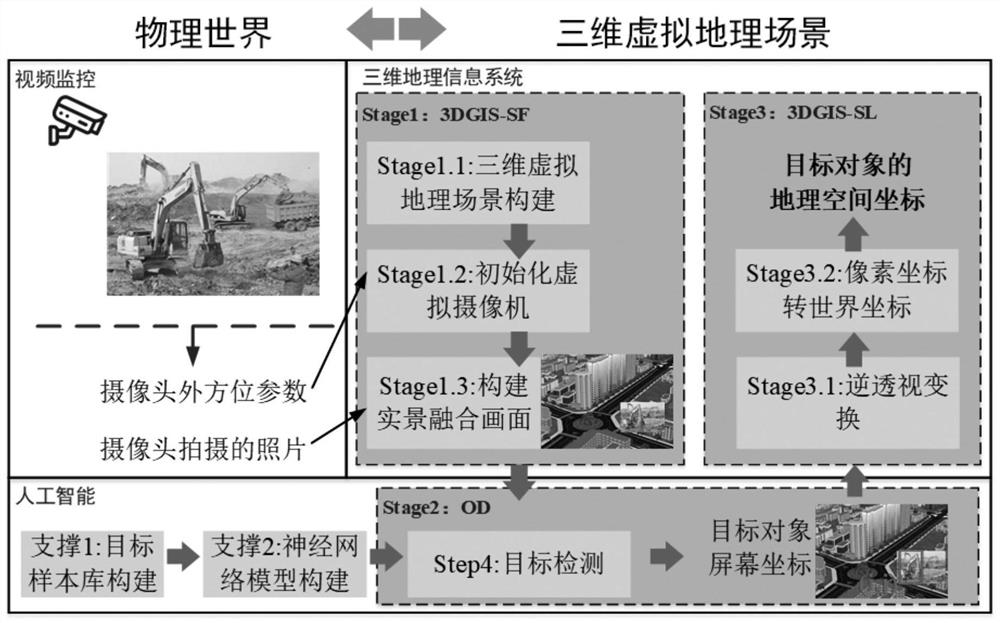
[0119] In order to reflect the practical value of the method in this paper, the suspected illegal construction behavior of tower base video supervision in the field of natural resource monitoring and supervision is used as the basic scene of the experiment, and the Nanjing Jiangxinzhou area is selected as the experimental area, and the high-tower camera is used as the basic experimental video source. The basic form of constructing a 3D virtual geographic environment is to construct a 3D virtual geographic scene based on 4D products. The input data includes NASA Earth Data 12.5M spatial resolution DEM data, and high-resolution remote sensing image data is selected from Tiandi Remote Sensing Image Data. Use the surveying and mapping method to collect the position of the camera, import the data into the SuperMap platform, analyze the video image and fuse it with the 3D scene to construct a 3D real-scene fusion scene.

[0120] This example realizes the target recognition and spatia...


PUM


Abstract

The invention discloses a monocular camera target detection and spatial positioning method based on a three-dimensional virtual geographic scene, which realizes target object detection and geographic space coordinate calculation under the condition of a monocular camera. Comprising the following steps: S1, constructing a live-action fusion picture based on a three-dimensional virtual geographic scene, and realizing fusion display of a video and a three-dimensional scene; and S2, target detection of the live-action fusion image containing the video is carried out based on a deep learning model, and a pixel value of a detection target is acquired. And S3, finally realizing conversion from pixel coordinates to geographic space coordinates based on a geographic space coordinate resolving method of the three-dimensional virtual geographic scene. The monocular camera is used for target monitoring and space positioning, the requirement for monitoring equipment is low, the single sensor has unique advantages in data processing and equipment cost, and the method can be applied to tower footing video natural resource suspected illegal sign monitoring and supervision and planning red line three-dimensional superposition space analysis. Therefore, suspected illegal land use signs can be quickly found, and the automation efficiency of monitoring and supervision of the suspected illegal signs is effectively improved.

Description

technical field [0001] The invention relates to the technical field of three-dimensional target detection and spatial positioning, in particular to a monocular camera target detection and spatial positioning method based on a three-dimensional virtual geographic scene. Background technique [0002] The rapid construction of intelligent geospatial applications such as smart cities, land perception, and space-time information cloud platforms has promoted the deep integration of artificial intelligence technology and geographic applications. Among them, 3D object detection and spatial positioning have become important directions. However, various methods of traditional 3D object detection mainly rely on depth cameras or multi-eye vision, which have high requirements on hardware conditions, and are difficult to be extended to applications in smart cities, land perception, and space-time information cloud platforms. How to detect the target object and calculate its geospatial coo...

Claims


Application Information

Patent Timeline
IPC IPC(8): G06T17/05G06T19/00G06T7/80G06K9/62G06N3/04G06N3/08G06V10/80G06V10/774G06V10/764G06V10/82
Inventor 沈健殷海军吕孝晨
Owner NANJING GUOTU INFORMATION IND
Why Eureka
Try Eureka