Basic geographic information data quality inspection method

A basic geographic information and data quality inspection technology, applied in the field of data quality inspection, can solve the problems of many drawbacks of data quality inspection methods, and achieve the effect of rapid modification, reducing the number of inspections, and improving inspection efficiency.

Pending Publication Date: 2022-05-06
NORTHEAST INST OF GEOGRAPHY & AGRIECOLOGY C A S +1
View PDF0 Cites 3 Cited by
  • Summary
  • Abstract
  • Description
  • Claims
  • Application Information

AI Technical Summary

Problems solved by technology

[0004] The purpose of the present invention is to provide a basic geographical information data quality inspection method to solve the problem that the traditional data quality inspection method proposed in the background technology has many disadvantages

Method used


Image

  • Basic geographic information data quality inspection method

Examples


Embodiment

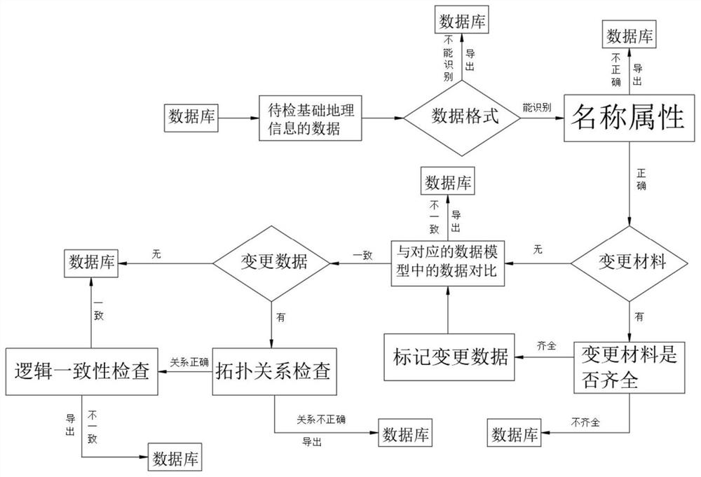
[0029] see figure 1 , the present invention provides a technical solution: a basic geographic information data quality inspection method, the basic geographic information data quality inspection method is as follows:

[0030] S1: select the data of the basic geographic information data to be checked from the database, then identify the data format of the data, if the data format can be identified, then enter the next step, if not, the data can be exported;

[0031] S2: check the name attribute of the data, the inspection content includes whether the length of the name is correct, whether there is a null value in the name, whether the code of the region name in the name is correct, if the name attribute is correct, then enter the next step, if it is incorrect, then mark the value of the name attribute Wrong location and export the data, mark the incorrect location in red;

[0032] S3: Check whether the data has changed materials. If there are no changed materials, go directly ...


PUM


Abstract

The invention belongs to the technical field of data quality inspection, and particularly relates to a basic geographic information data quality inspection method. The basic geographic information data quality inspection method comprises the steps of data selection of basic geographic information data to be inspected, data format inspection, name attribute inspection, change material inspection, data comparison, topological relation inspection, logic consistency inspection and data storage. According to the method, the basic geographic information data can be quickly and efficiently subjected to quality inspection, so that the detection efficiency is improved, error places in the basic geographic information data are marked, modification personnel can conveniently find the error places in time, and the accuracy of the detection result is improved by comparing the basic geographic information data to be detected with the data in the corresponding data model. According to the method, the situation that the name of the basic geographic information data is confused with the names of other basic geographic information data when an editor edits the data can be avoided.

Description

technical field [0001] The invention relates to the technical field of data quality inspection, in particular to a method for quality inspection of basic geographic information data. Background technique [0002] Basic geographic information data mainly refers to the most versatile and the largest sharing demand, which is adopted by almost all industries related to geographic information as a unified spatial positioning and basic geographic unit for spatial analysis. In addition, there is also a geographic coordinate system grid used for geographic information positioning, and its specific content is also the same as the scale of the map used. Relatedly, as the scale increases, the coverage of basic geographic information data should be more extensive. [0003] The traditional data quality inspection method is mainly manual inspection. Manual inspection has many disadvantages in inspection methods, inspection content, inspection expenses, inspection efficiency, etc., result...

Claims


Application Information

Patent Timeline
Patent Type & Authority Applications(China)
IPC IPC(8): G06F16/215G06F16/29
CPCG06F16/215G06F16/29
Inventor 卜坤王卷乐
Owner NORTHEAST INST OF GEOGRAPHY & AGRIECOLOGY C A S
Why Eureka
Try Eureka