Lake wetland crop area surveying and mapping method based on deep learning and unmanned aerial vehicle aerial photography and related algorithm

A deep learning and wetland technology, applied in the field of drone aerial photography, can solve the problems of low precision and accuracy, high operation difficulty, and high labor cost

Pending Publication Date: 2022-05-24
苏州品智信息科技有限公司
View PDF0 Cites 2 Cited by
  • Summary
  • Abstract
  • Description
  • Claims
  • Application Information

AI Technical Summary

Problems solved by technology

[0005] The purpose of the present invention is to provide a lake wetland crop area surveying and mapping method, which aims to solve the problems of high operational difficulty, high labor cost, and low precision and accuracy when surveying and mapping lake wetland crop area in the past

Method used


Image

  • Lake wetland crop area surveying and mapping method based on deep learning and unmanned aerial vehicle aerial photography and related algorithm
  • Lake wetland crop area surveying and mapping method based on deep learning and unmanned aerial vehicle aerial photography and related algorithm
  • Lake wetland crop area surveying and mapping method based on deep learning and unmanned aerial vehicle aerial photography and related algorithm

Examples


Embodiment 1

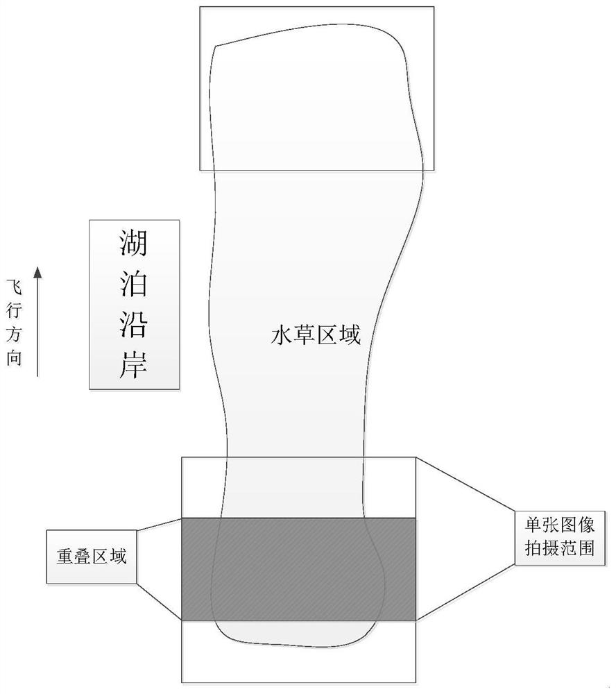
[0020] like figure 1 As shown, if the width of the aquatic plants along the shore can be covered by the width of the UAV's flight direction, the UAV can fly in the current direction once. The central position of the aquatic plant area in the horizontal direction of the drone body is helpful to reduce the distortion caused by the lens imaging in the horizontal direction and reduce the error of area statistics. Two adjacent images have at least 50% overlapping area. When images are spliced ​​in the vertical direction, more similar areas can be obtained, and a better splicing effect can be obtained.

Embodiment 2

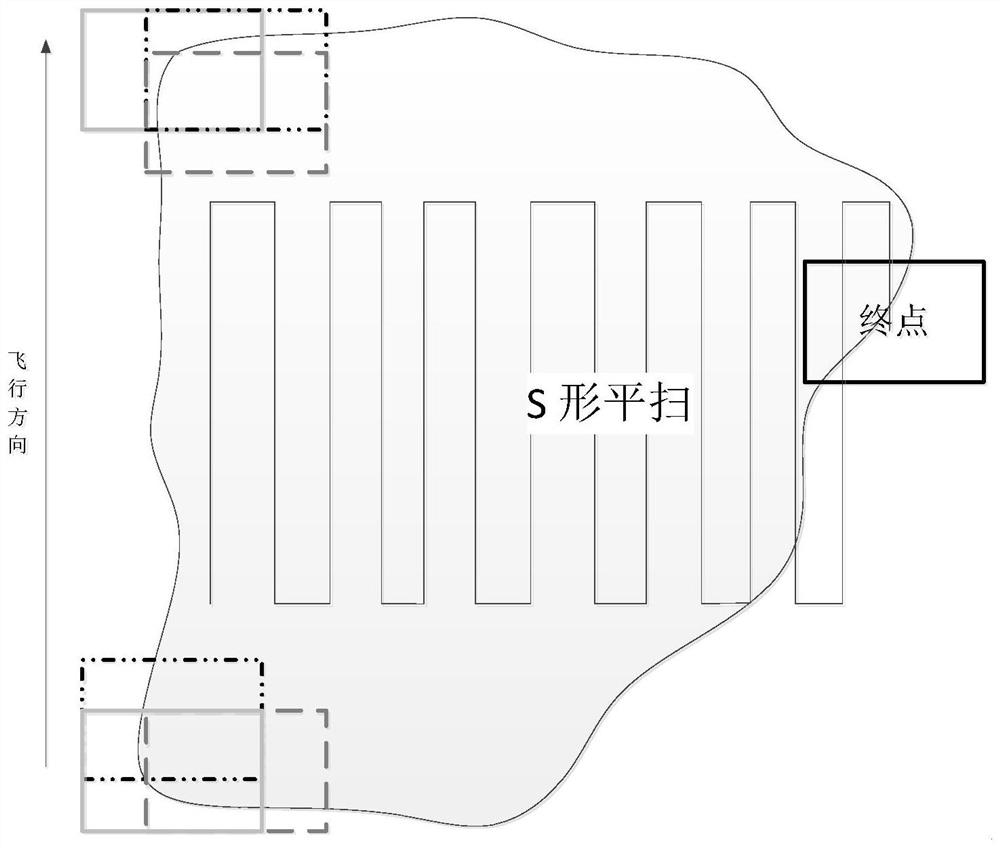
[0022] like figure 2 As shown, if the aquatic plants along the shore extend more into the lake, the width of the UAV's flight direction cannot be covered. It is necessary to control the UAV to take an S-shaped sweep of the surveying and mapping area. figure 1 The same as shown, the horizontal direction also needs to have an overlap area of ​​more than 50%.

Embodiment 3

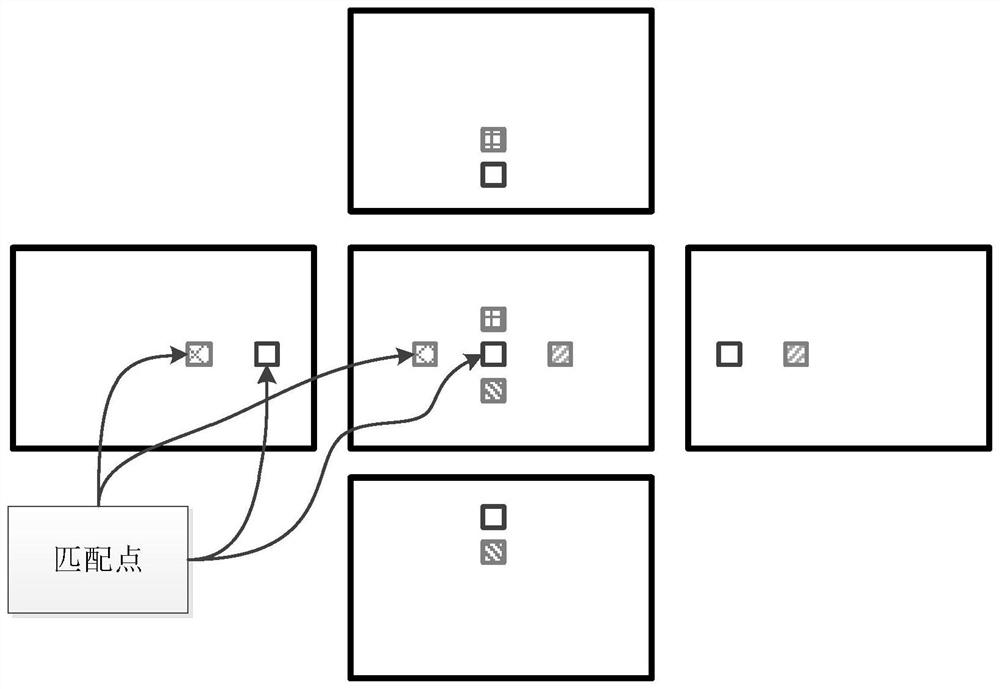
[0024] like image 3 As shown (the images around the picture are actually 50% overlapping areas to the middle image, and to illustrate the situation, they are separated), the images collected by the UAV carry the GPS location information and flight direction information at the time of shooting. According to the GPS location information, the captured images are sorted to obtain the closest image in the four directions for each image in the image set. Combining four adjacent images, after correcting the distortion of each image and its adjacent images, image fusion is performed until all the images in the image set are fused into a large image, and the mosaic map of the aerial photography area is obtained.

[0025] In the specific stitching process, the black and blue areas in the middle image are used as matching templates. In the image on the left, the closest position to these two areas is found, and the slight misalignment during aerial photography is corrected to achieve be...


PUM


Abstract

The invention discloses a lake wetland crop area surveying and mapping method based on deep learning and unmanned aerial vehicle aerial photography and related algorithms. The surveying and mapping method relates to an aerial photography image acquisition scheme, a plane front-view projection image generation algorithm, a wetland crop area identification and segmentation algorithm and an area statistical method. The aerial image acquisition scheme specifies the requirements of the unmanned aerial vehicle for image acquisition; the plane front-view projection image generation algorithm describes an algorithm for generating a plane front-view projection image of a shooting area based on an image acquired by the unmanned aerial vehicle; the wetland crop identification and segmentation algorithm describes an algorithm for identifying and segmenting aquatic plant areas such as reeds and wormwood in a lake wetland area based on a deep learning algorithm; the area statistical method describes a method for counting the areas of crops such as reeds and wormwood based on plane front-view projection images and recognized crops such as reeds and wormwood. The method provided by the invention finally realizes the functions of identifying aquatic crops such as reeds and wormwood and respectively calculating the areas of the aquatic crops.

Description

technical field [0001] The invention relates to the field of aerial photography of unmanned aerial vehicles, the field of surveying and mapping, and the field of computer algorithms, in particular to artificial intelligence algorithms such as image processing and deep learning. Background technique [0002] With the development of science and technology, UAV equipment has gradually become popular, and the imaging quality of the camera carried by the UAV has been continuously improved, so that the low-altitude aerial image of the UAV can clearly reflect the surveying and mapping area, and the content of the surveying and mapping area will be more accurate and refined in the later analysis. . However, most of the traditional surveying and mapping are still based on GPS points, and the area is fitted by recording a large number of GPS points. This method has a large error in calculating the area of ​​the surveying and mapping area, and at the same time, it cannot provide a mor...

Claims


Application Information

Patent Timeline
Patent Type & Authority Applications(China)
IPC IPC(8): G06T7/62G06T7/10G01C11/04
CPCG06T7/62G06T7/10G01C11/04G06T2207/10004G06T2207/20081
Inventor 不公告发明人
Owner 苏州品智信息科技有限公司
Why Eureka
Try Eureka