Low-altitude multispectral remote sensing water quality monitoring method for surface water body

A water quality monitoring and multi-spectral technology, applied in the field of multi-spectral remote sensing, can solve problems such as low accuracy, satellite remote sensing is easily affected by the atmosphere, and ground equipment monitoring coverage is small

Pending Publication Date: 2022-06-03
上海同繁勘测工程科技有限公司 +1
View PDF0 Cites 0 Cited by
  • Summary
  • Abstract
  • Description
  • Claims
  • Application Information

AI Technical Summary

Problems solved by technology

[0004] The invention provides a low-altitude multi-spectral remote sensing water quality monitoring method for surface water bodies to solve the technical problems that satellite remote sensing is easily affected by the atmosphere, which leads to low accuracy and the small coverage of ground equipment monitoring, which makes it impossible to monitor large areas.

Method used


Image

  • Low-altitude multispectral remote sensing water quality monitoring method for surface water body
  • Low-altitude multispectral remote sensing water quality monitoring method for surface water body
  • Low-altitude multispectral remote sensing water quality monitoring method for surface water body

Examples


Embodiment Construction

[0053] In order to make the above objects, features and advantages of the present invention more clearly understood, the specific embodiments of the present invention will be described in detail below with reference to the accompanying drawings.

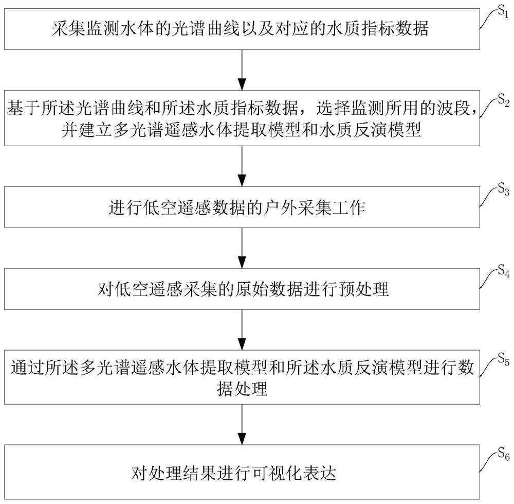
[0054] like Figure 1-8 As shown, an embodiment of the present invention provides a low-altitude multispectral remote sensing water quality monitoring method for surface water bodies, comprising the following steps:

[0055] S 1 : Collect the spectral curve of the monitored water body and the corresponding water quality index data;

[0056] S 2 : Based on the spectral curve and the water quality index data, select the band used for monitoring, and establish a multi-spectral remote sensing water body extraction model and a water quality inversion model;

[0057] S 3 : outdoor collection of low-altitude remote sensing data;

[0058] S 4 : Preprocess the raw data collected by low-altitude remote sensing;

[0059] S 5 : perform d...


PUM

PropertyMeasurementUnit
Overlap degreeaaaaaaaaaa

Abstract

The invention provides a low-altitude multispectral remote sensing water quality monitoring method for a surface water body. The low-altitude multispectral remote sensing water quality monitoring method comprises the following steps: S1, acquiring a spectral curve of a monitored water body and corresponding water quality index data; s2, on the basis of the spectral curve and the water quality index data, selecting a wave band for monitoring, and establishing a multispectral remote sensing water body extraction model and a water quality inversion model; s3, performing outdoor acquisition work of low-altitude remote sensing data; s4, preprocessing the original data acquired by low-altitude remote sensing; s5, performing data processing through the multispectral remote sensing water body extraction model and the water quality inversion model; and S6, carrying out visual expression on a processing result. The method fills the vacancy of water quality monitoring in satellite remote sensing monitoring and ground monitoring methods, can be applied to daily conventional water quality monitoring, and can quickly obtain the surface water quality condition of the surface water body.

Description

technical field [0001] The invention relates to the technical field of multi-spectral remote sensing, in particular to a low-altitude multi-spectral remote sensing water quality monitoring method for surface water bodies. Background technique [0002] At present, there are two main methods for water quality monitoring of surface water bodies: satellite remote sensing and ground monitoring, but both monitoring methods have some problems. Satellite remote sensing has a large scale and low accuracy, and is affected by atmospheric conditions, so it is not suitable for small and medium-sized water bodies at mesoscale; the ground equipment and laboratory tests used in ground monitoring have small coverage and low efficiency, and cannot be used for large-scale monitoring. area monitoring. [0003] With the development and popularization of UAVs and their mounted equipment, low-altitude multispectral remote sensing technology has gradually entered the stage of practical application...

Claims


Application Information

Patent Timeline
Patent Type & Authority Applications(China)
IPC IPC(8): G01N21/25G06T5/50G06T5/00G06N20/00G06K9/62G06F17/18
CPCG01N21/25G06T5/006G06T5/50G06N20/00G06F17/18G06T2207/10032G06T2207/20221G06F18/2411Y02A20/152
Inventor 周骁腾周源刘春曾勇
Owner 上海同繁勘测工程科技有限公司
Why Eureka
Try Eureka