Supercharge Your Innovation With Domain-Expert AI Agents!

GPS trajectory optimization method and system

A trajectory optimization and control module technology, applied in the field of communication, can solve problems such as difficult to balance dots and trajectories, achieve the effects of improving integrity and reliability, improving trajectory coordinates, and reducing equipment flow

Inactive Publication Date: 2022-06-03
上海万位科技有限公司
View PDF0 Cites 0 Cited by
  • Summary
  • Abstract
  • Description
  • Claims
  • Application Information

AI Technical Summary

Problems solved by technology

At the same time, due to the uncertainty of the vehicle's running speed, it is difficult for this strategy to take into account both RBI and trajectory.

Method used


Image

  • GPS trajectory optimization method and system
  • GPS trajectory optimization method and system
  • GPS trajectory optimization method and system

Examples


Embodiment Construction

[0041] The present invention is further described below by way of examples, but the present invention is not limited to the scope of the described examples.

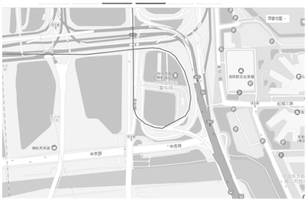
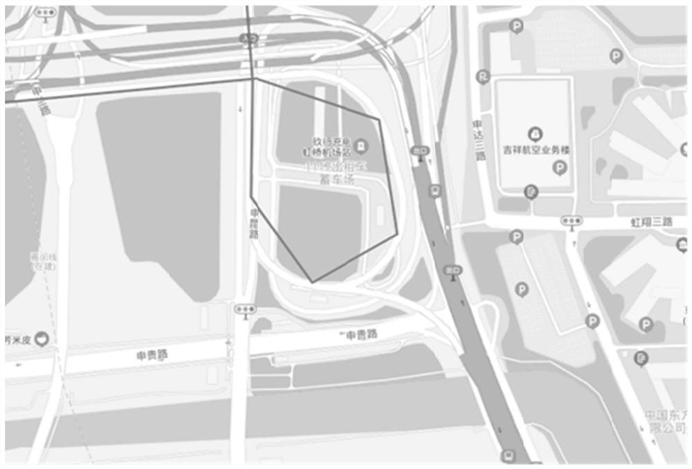
[0042] figure 1 In order to adopt the effect diagram of the GPS trajectory optimization strategy in this case, and figure 2 The effect diagram of the GPS trajectory optimization strategy that is not adopted in this case.

[0043] combine figure 1 and figure 2 It can be seen from the comparison that the figure obtained by the GPS trajectory description without using the GPS trajectory optimization method in this case is an irregular polygon, and the driving trajectory often has breakpoints and straight lines.

[0044] and with figure 2 The difference is that the graph drawn by the GPS trajectory using the GPS trajectory optimization method in this case is a smooth curve, indicating that this case can realize the traffic transmission that is used and transmitted, and the trajectory coordinates are complete and relia...


PUM


Abstract

The invention discloses a GPS track optimization method and system. The GPS trajectory optimization method comprises the following steps: S1, a data acquisition module acquires vehicle information and positioning information in real time, and sends the vehicle information and the positioning information to a control module and an auxiliary module; s2, the auxiliary module calculates attitude information according to the vehicle information and sends the attitude information to the control module; s3, the control module judges whether vehicle driving meets curve driving conditions or not according to the attitude information and the positioning information, if yes, a supplementary transmission strategy is carried out to correct the positioning information, and the corrected positioning information is transmitted to a server through a wireless communication module; and if not, the positioning information is transmitted to the server through the wireless communication module at a preset first time interval. According to the GPS trajectory optimization method and system, high-precision trajectory reduction and efficient transmission can be realized.

Description

technical field [0001] The invention relates to the field of communications, in particular to a GPS trajectory optimization method and system. Background technique [0002] Traditional positioning devices on the market generally have the function of coordinate positioning and the basic function of uploading coordinates. However, in actual use scenarios, due to signal problems and environmental interference problems, the network communication of the device is interrupted, or the coordinate positioning fails. Therefore, the traditional positioning device generally adopts the strategy of using and transmitting, and solves the problem of trajectory loss by increasing the upload frequency. The final result directly leads to large network traffic and high device trajectory density. Most of these extra points are meaningless. [0003] In the current market, if you want to better track the device, the general strategy is to upload at a fixed time. However, the technical difficulty...

Claims


Application Information

Patent Timeline
IPC IPC(8): G01S19/37G01S19/23G05B19/042G08C17/02
CPCG01S19/37G01S19/23G05B19/0423G08C17/02
Inventor 姚定虎
Owner 上海万位科技有限公司
Features
  • R&D
  • Intellectual Property
  • Life Sciences
  • Materials
  • Tech Scout
  • Unparalleled Data Quality
  • Higher Quality Content
  • 60% Fewer Hallucinations
Learn More