

Combined positioning method based on night moonlight polarization-starlight information fusion
A combined positioning and starlight technology, applied in astronomical navigation, navigation calculation tools, etc., to achieve strong applicability and improve autonomous navigation capabilities.
Active Publication Date: 2022-06-10
BEIHANG UNIV
View PDF20 Cites 0 Cited by
- Summary
- Abstract
- Description
- Claims
- Application Information
AI Technical Summary
Problems solved by technology
[0004] Existing combined positioning methods, such as the paper "A Full Information Navigation Filtering Algorithm Based on INS / GPS / CNS" utilizes GPS information, and the system's anti-interference ability is relatively low Weak, poor autonomy; while the combined positioning method based on polarization and starlight information, such as the authorized Chinese invention patent "An autonomous navigation and positioning method based on polarization / astronomical assistance (ZL201911250913.8)" utilizes the attitude provided by the inertial navigation system platform, the positioning result will be limited by the inertial navigation accuracy
Method used
View moreImage
Smart ImageViewing Examples

Examples
Embodiment Construction
Login to View More PUM
 Abstract
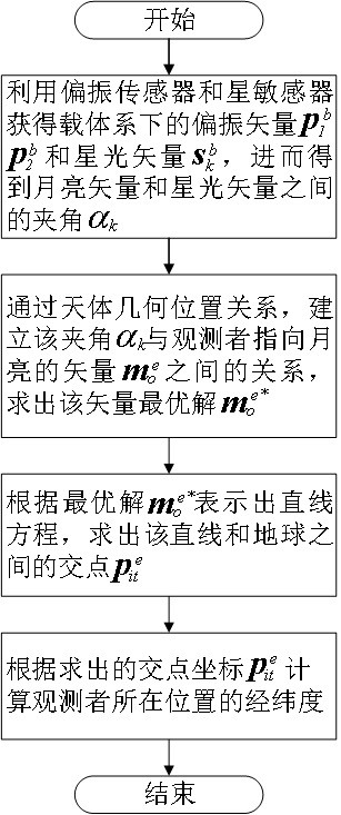
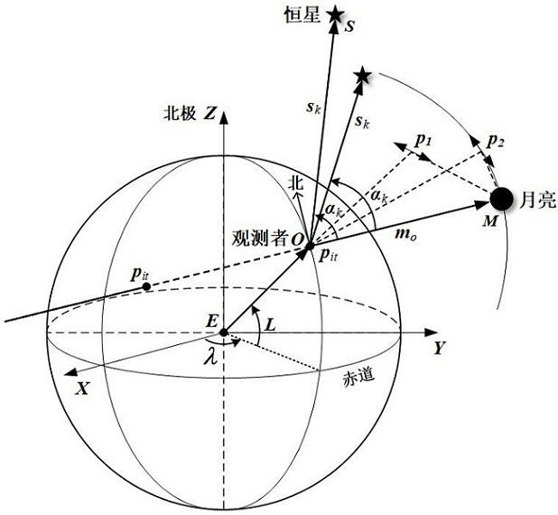
The invention relates to a combined positioning method based on night moonlight polarization-starlight information fusion, which comprises the following steps: firstly, acquiring polarization vector information by using a polarization sensor, acquiring starlight vector information by using a star sensor, and calculating an included angle between a moonlight vector and a starlight vector according to the polarization vector information and the starlight vector information; secondly, establishing a relationship between the included angle obtained in the previous step and a vector pointing from the observer position O to the moon bright spot M through a geometric position relationship of a celestial body, and solving an optimal solution of the vector; thirdly, calculating coordinates of an intersection point of the earth and the straight line through the optimal solution according to an earth ellipsoid equation and a straight line equation which takes the optimal solution as a direction and passes through a moon bright point; and finally, the longitude and latitude values of the position of the observer are calculated according to the intersection point coordinates. According to the invention, through combination of night sky polarization information and starlight information, the problem of autonomous positioning of an unmanned system in the atmosphere is solved.
Description
technical field [0001] The invention belongs to the field of autonomous positioning of unmanned systems, and in particular relates to a combined positioning method based on fusion of moonlight polarization and starlight information at night. Background technique [0002] The night environment has the characteristics of low visibility and poor visibility, and having the night navigation capability is of great significance for unmanned systems to complete tasks. For the unfamiliar navigation environment at night, a single navigation method has its own limitations. Therefore, in practical applications, a combination of multiple methods is often used for navigation. A combination of inertial, astronomical and satellite modes is currently the most commonly used navigation method. However, there is error accumulation in inertial navigation, and satellite navigation is prone to failure in urban construction areas or electromagnetic interference environments. Astronomical navigati...
Claims
Login to View More Application Information
Patent Timeline
 Patent Type & AuthorityApplications(China)
IPC IPC(8): G01C21/02G01C21/20
CPCG01C21/02G01C21/20
Inventor王岩杨悦婷杨健郭雷陈泰航
OwnerBEIHANG UNIV