Method and device for determining road occupation information

A technology for lanes and construction areas, applied in the field of computer vision, can solve problems such as the difficulty of accurately giving construction markers in rectangular annotation frames and inaccurate assessment of road occupation in construction areas, so as to improve algorithm efficiency, reduce detection range, and improve efficiency Effect

Pending Publication Date: 2022-07-19
HUAWEI TECH CO LTD
View PDF0 Cites 0 Cited by
  • Summary
  • Abstract
  • Description
  • Claims
  • Application Information

AI Technical Summary

Problems solved by technology

[0004] In the existing construction area identification, the detected construction area markers are mainly framed by a rectangular labeling frame to identify the road construction area. The rectang

Method used


Image

  • Method and device for determining road occupation information
  • Method and device for determining road occupation information
  • Method and device for determining road occupation information

Examples


Example Embodiment

[0060] The technical solutions in the present application will be described below with reference to the accompanying drawings.

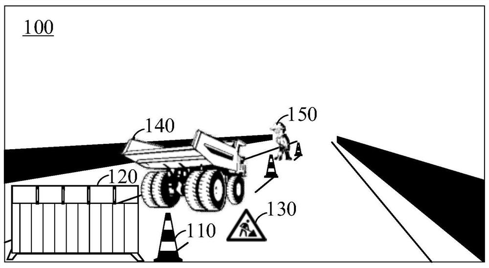
[0061] figure 1 It is a schematic diagram of a road construction area applicable to the embodiments of the present application. figure 1 It may be a front image 100 captured by a camera on the vehicle.

[0062] The image 100 includes a road construction area consisting of various landmarks such as traffic cones 110 , road barriers 120 , warning signs 130 , construction vehicles 140 and / or construction personnel 150 . Although the above road construction area markers can be classified as obstacles, the construction area has higher-level semantic information, so millimeter-wave radar (Radar) often does not have the ability to perceive complex construction areas. The sensors used in the current road construction area detection solutions include Lidar and Camera. Among them, the camera has the advantages of low cost, small size, easy deployment and eas...


PUM


Abstract

The invention discloses a road occupation information determination method and device, belongs to the field of computer vision, and can be used for auxiliary driving and automatic driving. The method comprises the steps that a first image is acquired, a first region of interest (ROI) is determined according to the first image, and the first ROI comprises at least one construction area marker; obtaining a first binary image of the ROI; performing edge enhancement processing on the at least one construction area marker in the first binary image to obtain a second binary image; obtaining a junction point set of the at least one construction area marker and the road surface according to the second binary image; and determining road occupation information of the at least one construction area marker according to the junction point set of the at least one construction area marker and the road surface, and sending the road occupation information. According to the method, the accuracy of determining the road occupation information of the construction area markers is improved, so that the decision-making accuracy of the vehicle in auxiliary driving and automatic driving is improved.

Description

technical field [0001] The present application relates to the field of computer vision, and in particular, to a method and device for determining lane occupation information. Background technique [0002] With the development of society, intelligent terminals such as intelligent transportation equipment, smart home equipment, and robots are gradually entering people's daily life. Sensors play a very important role in smart terminals. Various sensors installed on the smart terminal, such as millimeter-wave radar, lidar, camera, ultrasonic radar, etc., perceive the surrounding environment during the movement of the smart terminal, collect data, and identify and track moving objects. As well as the identification of static scenes such as lane lines and signs, and combined with navigator and map data for path planning. Sensors can detect possible dangers in advance and assist or even take necessary evasion measures autonomously, effectively increasing the safety and comfort of...

Claims


Application Information

Patent Timeline
IPC IPC(8): G06V10/25G06K9/62G06T5/00G06T5/30G06T7/155G06T7/187G06T7/90G06V10/762
CPCG06T5/008G06T7/187G06T5/30G06T7/90G06T5/002G06T2207/20152G06T7/155G06F18/2321G06T5/00G06V10/25G06V10/762G06F18/00
Inventor 马志贤吴家俊云一宵池清华
Owner HUAWEI TECH CO LTD
Why Eureka
Try Eureka