Landform grid generating method being correlated with viewpoint and based on four-queue optimization

A grid generation and queuing technology, applied in image data processing, 3D modeling, instruments, etc., can solve the problems of consuming CPU time and failure to use the continuity of the field of view, so as to achieve less time overhead for sorting and smooth real-time roaming , the effect of improving efficiency

Inactive Publication Date: 2006-05-31
ZHEJIANG UNIV
View PDF0 Cites 0 Cited by
  • Summary
  • Abstract
  • Description
  • Claims
  • Application Information

AI Technical Summary

Problems solved by technology

[0003] 1. Bottom-up layer-by-layer simplification generation method, that is, starting from the bottom layer of the grid, merging triangles that meet the conditions until the error of the triangles meets a given threshold, see [Linsdrom1996]PeterLindstrom, David Koller, William Ribarsky , Larry F. Hodges, Nick Faust, and Gregory Turner, "Real-time, Continuous Level of Detail Rendering of Height Fields," Proceedings of SIGGRAPH 96, 109-118., Simplification depends on the size of the terrain's finest resolution grid, Data that is relative to the entire terrain, both in terms of computation and storage, is not valid for large-scale terrains
[0004] 2. Gradual top-down refinement, the terrain grid is gradually subdivided and refined from the thickest triangle until the error of the triangle meets a given threshold, see [Linsdrom2001, 2002] (Peter Lindstromand V.Pascucci, " Visualization of large terrains made easy,” IEEE Visualization 2001, 363-370, Oct. 2001; Peter Lindstrom and V. Pascucci. “Terrain Simplification Simplified: A General Framework for View-Dependent Out-of-Core Visualization”. IEEE Transaction on Visualization and Computer Graphics, 2002.), this method starts from the thickest two triangles for each frame, performs top-down subdivision, and cannot take advantage of the coherence between the viewing areas
The number of triangles can be determined according to the rendering ability. The ROAM algorithm guarantees the rendering at a fixed frame rate for the real-time terrain rendering system, but in the real-time rendering process, the priority queue needs to be updated each time, and its complexity is O(nlogn). Calculating priorities also consumes CPU time

Method used


Image

  • Landform grid generating method being correlated with viewpoint and based on four-queue optimization
  • Landform grid generating method being correlated with viewpoint and based on four-queue optimization
  • Landform grid generating method being correlated with viewpoint and based on four-queue optimization

Examples


Embodiment Construction

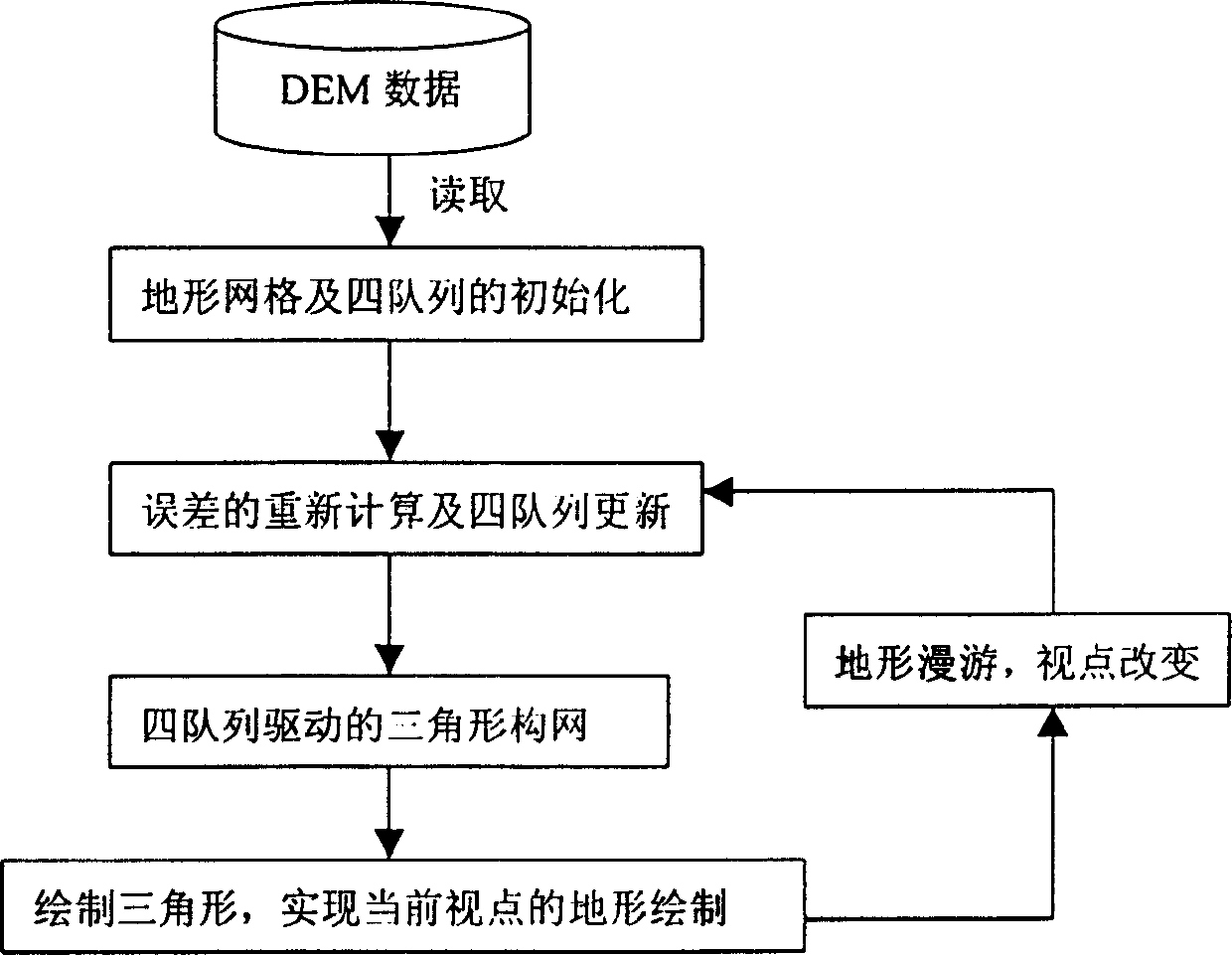
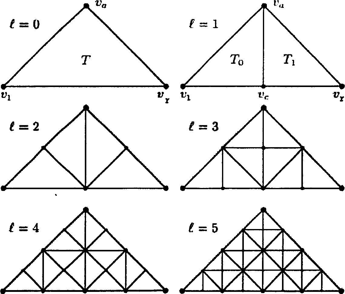
[0020] As shown in Figure 1, the perspective-related terrain grid generation method based on four-column optimization proposed by the present invention includes the initialization of terrain grid and four-column, error recalculation and four-column update, four-column drive, etc. There are three basic steps in the construction of waist right-angled triangle network. Among them, the four queues refer to the four isosceles right-angled triangle queues, which are the queues Q that need to be divided. s and the queue Q that does not need to be split ns , the queue Q that needs to be merged m and a queue Q that does not need to be merged nm . where queue Q s and queue Q m is a sorted queue, and the queue Q ns and queue Q nm is an unsorted queue.

[0021] The specific process can be described as: the system first reads the original terrain data, that is, DEM data, then uses the three steps of the present invention to complete the formation of an isosceles right triangle, and...


PUM


Abstract

The invention discloses a viewpoint-related terrain grid generation method based on four-column optimization. Including the initialization of the terrain grid and the four queues; the recalculation of the error and the update of the four queues; the construction of the isosceles right triangle network driven by the four queues. This method deals with the original terrain data, can complete the generation of terrain grid in a limited time, and guarantees the quality of the display picture at the same time. The present invention utilizes the coherence between viewing domains, can effectively control the number of isosceles right-angled triangles in the terrain grid, adopts four queues of terrain grid drive, and only sorts the subdivision queue and the merge queue. When it is large, the number of items in the subdivision queue and the merge queue is very small, which reduces the sorting time, improves the efficiency of generating terrain grids, makes the real-time roaming of the terrain more smooth, and the quality of the displayed picture is higher.

Description

technical field [0001] The present invention relates to general image data processing or generation, in particular to a viewpoint-related terrain grid generation method based on four-column optimization. technical background [0002] In order to realize large-scale terrain real-time roaming, the terrain grid generated from the original terrain data must be simplified. The viewpoint-related terrain mesh simplification generation algorithm refers to the effective simplification of the terrain mesh according to the given error threshold under the current viewpoint, so that the terrain triangular mesh generated after simplification and the original mesh are observed at a given viewpoint almost no difference. There are several methods for terrain mesh simplification generation: [0003] 1. Bottom-up layer-by-layer simplification generation method, that is, starting from the bottom layer of the grid, merging triangles that meet the conditions until the error of the triangles mee...

Claims


Application Information

Patent Timeline
Patent Type & Authority Patents(China)
IPC IPC(8): G06T17/50G06T17/05
Inventor 华炜陆艳青周栋鲍虎军
Owner ZHEJIANG UNIV
Why Eureka
Try Eureka