Double-star positioning navigation method based on GPS

A positioning and navigation, dual-satellite technology, applied in the field of GPS positioning, can solve problems such as insufficient number of satellites that can be observed, GPS failure, etc.

Inactive Publication Date: 2007-01-03
SHANGHAI JIAO TONG UNIV
View PDF0 Cites 11 Cited by
  • Summary
  • Abstract
  • Description
  • Claims
  • Application Information

AI Technical Summary

Problems solved by technology

The present invention adopts GPS dual-satellite positioning based on digital map information...

Method used


Image

  • Double-star positioning navigation method based on GPS
  • Double-star positioning navigation method based on GPS
  • Double-star positioning navigation method based on GPS

Examples


Embodiment Construction

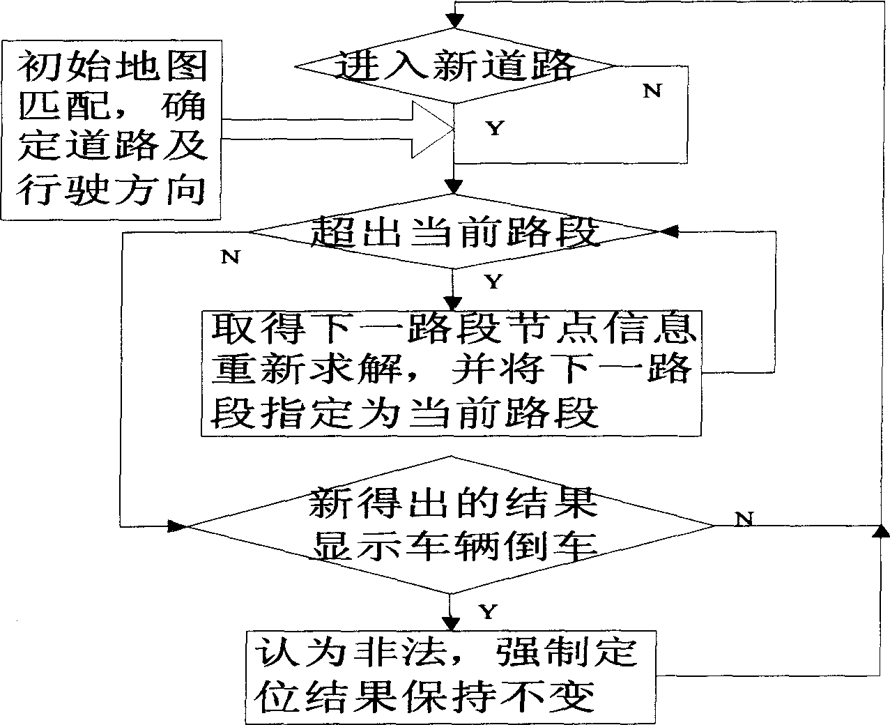
[0033] Below in conjunction with specific embodiment the technical scheme of the present invention is described in further detail, as figure 1 shown.

[0034] For vehicle navigation systems like trains or buses whose trajectories are known, geographic data of road trajectories can be established as a general database. As long as you know the distance traveled by the vehicle from a known point or the proportional relationship in a specific road section, you can query the current geographic location through the database.

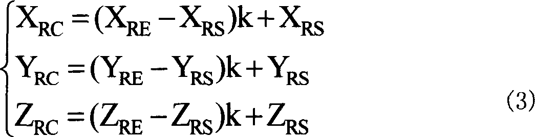
[0035] When the train or bus starts to run, the vehicle is at the starting position of the entire trajectory, and the straight line segment starting from the starting point of the trajectory is taken as the current segment. When the vehicle starts to run, the vehicle is on the road section, and the position of the vehicle can be determined by the starting point position information of the straight line road section and a scale factor. At this time, if the ve...


PUM


Abstract

A double stars orientation navigation method bases on the GPS. Divide up the movement track of vehicle into order coterminous beeline segments and confirm the channel of aim vehicle from the beeline segments. Set up positional restriction equation of vehicle on the channel, get the needed information form the signal of the two stars by GPS in vehicle to found the secondary planet observation equation. Orient the two stars and work out the vehicle position and proportion gene from the vehicle position restriction equation and secondary planet observation equation. Set up the directional restriction equation of vehicle speed on the current channel and form the Doppler observation equation of the two GPS secondary planet using the incepted information from the GPS in vehicle. The double stars test speed is working out the vehicle movement speed by directional restriction equation of vehicle speed and the Doppler observation equation to confirm the state of current vehicle through the proportion gene. It solves the disabled problem of GPS for lock of the observation amount to secondary planet to keep the precision of the GPS orientation.

Description

technical field [0001] The invention relates to a method in the technical field of GPS positioning, in particular to a GPS-based dual-satellite positioning and navigation method. Background technique [0002] The Global Positioning System (GPS) can provide positioning navigation and time reference information quickly, accurately and all-weather, and is currently the mainstream navigation method. GPS positioning based on a single point requires four visible satellites. When the visible satellites of the GPS are less than 4, the GPS will reduce the positioning accuracy or even fail to perform continuous positioning. However, in the urban environment, there are many high-rise buildings, as well as the interference of three-dimensional traffic and bridges, which may cause the GPS visible satellites to fail to meet the standard. Multiple road tests in the Xujiahui area of ​​Shanghai show that only 60% of the road sections can observe four or more satellites, while more than 90% ...

Claims


Application Information

Patent Timeline
IPC IPC(8): G01S5/02G01S1/02G01S19/50G01S19/52
Inventor 沈旸李树广
Owner SHANGHAI JIAO TONG UNIV
Why Eureka
Try Eureka