Precision geographic location system and method utilizing an image product

a geographic location and image technology, applied in the field of precise geographic location system and targeting accuracy using an image product, can solve the problems of reducing the geographic location accuracy of targets within the field of view of military planners and campaigners, and achieving the full capacity of airborne synthetic aperture radar (sar) implemented, so as to improve the target accuracy of a gps guided munition

Inactive Publication Date: 2019-03-05
LITEL INSTR
View PDF38 Cites 7 Cited by
  • Summary
  • Abstract
  • Description
  • Claims
  • Application Information

AI Technical Summary

Benefits of technology

[0014]Another exemplary embodiment relates to a method for improving target accuracy of a GPS guided munition. The method includes acquiring a firing station image and precisely locating firing and placement locations using a remapped image. The method further includes acquiring GPS locations of the firing emplacements, and using a difference from the firing emplacement locations and the GPS locations to correct targeting.

Problems solved by technology

Military planners and campaigners heretofore have not achieved the full capacity of airborne synthetic aperture radar (SAR) implemented on unmanned aerial vehicles (UAV).
A significant disadvantage of UAV SAR systems is lower geographic location accuracy of targets within their field of view.
The ability to effectively attack targets with lighter munitions means a given weapons platform (e.g., missile carrying drone) can carry a greater number of munitions and potentially destroy a greater number of targets.
However, launching multiple munitions per target is costly.
A further drawback of joy sticking for accuracy is that a single munition requires the full attention of the bombardier for the duration of the drop (˜1 minute).

Method used


Image

  • Precision geographic location system and method utilizing an image product
  • Precision geographic location system and method utilizing an image product
  • Precision geographic location system and method utilizing an image product

Examples


Embodiment Construction

[0038]By improving targeting, and / or location accuracy, the method and system disclosed herein enables the advantageous tactics of multiple targeting at greater standoff distances with less time spent in high danger zones in one embodiment. Although described below with respect to UAV and targeting applications, the method and systems described herein can be utilized in a variety of targeting, location, navigational, and control applications without departing from the scope of the invention. The methods disclosed herein can be implemented using a computer system or other electronic hardware implementing the steps disclosed herein as routines, instructions or other computer commands.

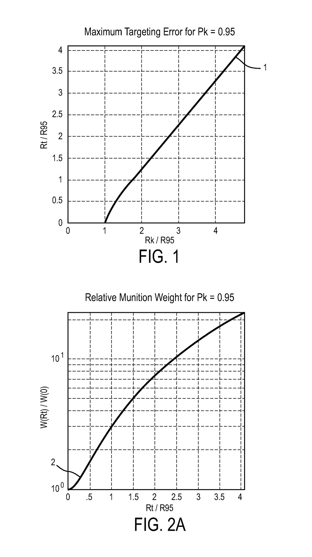
[0039]Taken by themselves, typical SAR errors can be ˜5 m which is generally not useful for most hard targets (Rs˜1m) and for soft targets requires larger munitions and associated collateral damage. A remapping technique for target location that significantly reduces these geographic location errors can b...


PUM


Abstract

A method of mapping a target region image to a referenced image includes steps of acquiring the target region image. The method also includes acquiring the referenced image overlapping the target region image. The method further includes determining a number of common subregions in an intersection of the referenced image and the target region image, determining offsets between the common subregions, computing a distortion map of the target region image over the intersection, and remapping the target region image to match the reference image. The method can be utilized in a Unmanned Aerial Vehicle (UAV) and the target image can be a SAR image.

Description

CROSS-REFERENCE TO RELATED PATENT APPLICATIONS[0001]The present application is a continuation of U.S. patent application Ser. No. 13 / 443,684, filed on Apr. 10, 2012, now U.S. Pat. No. 9,074,848, which claims the benefit of and priority to U.S. Provisional Application Ser. No. 61 / 517,141, filed Apr. 13, 2011, both of which are incorporated by reference in their entireties and for all purposes.BACKGROUND[0002]The present specification generally relates to systems for and methods of increasing the location accuracy (e.g., geographic location accuracy). More particularly, the present specification relates to increasing location and / or targeting accuracy using an image product.[0003]It is desirable to increase location and / or targeting accuracy in a variety of systems. An example of a system that could benefit from increased location and / or targeting accuracy is a system that uses a synthetic aperture radar or other battlefield image products.[0004]Military planners and campaigners heret...

Claims


Application Information

Patent Timeline
Patent Type & Authority Patents(United States)
IPC IPC(8): F41G7/34G06T7/00G01S13/90G01S19/48G06G7/80G06T7/11
CPCF41G7/346G06T7/0081G06G7/80G01S19/48G01S13/9005G06T7/001G06T7/11G01S7/412G01S7/4802G01S13/86F41G7/2246F41G7/343G06T7/337F41G7/2226F41G7/2286G01S17/90G01S17/86G01S13/9027G01S19/485G01S7/40G01C21/005
Inventor HUNTER, JR., ROBERT O.SMITH, ADLAI H.
Owner LITEL INSTR
Why Eureka
Try Eureka