Scalable method for rapidly detecting potential ground vehicle under cover using visualization of total occlusion footprint in point cloud population

a technology of point cloud population and scalable method, which is applied in the field of radar systems, can solve the problems of obscuring the presence of ground-based targets, hammering the ability to detect targets using such a ladar system, and difficult target detection

a technology of point cloud population and scalable method, which is applied in the field of radar systems, can solve the problems of obscuring the presence of ground-based targets, hammering the ability to detect targets using such a ladar system, and difficult target detection

US20050063593A1Inactive Publication Date: 2005-03-24THE BOEING CO

Image

  • Scalable method for rapidly detecting potential ground vehicle under cover using visualization of total occlusion footprint in point cloud population
  • Scalable method for rapidly detecting potential ground vehicle under cover using visualization of total occlusion footprint in point cloud population
  • Scalable method for rapidly detecting potential ground vehicle under cover using visualization of total occlusion footprint in point cloud population

Examples


Embodiment Construction

[0019] By way of overview, embodiments of the present invention provide for facilitating detection of an object in a point cloud of three-dimensional imaging data representing an area of study where the object potentially is obscured by intervening obstacles. The imaging data is processed to identify elements in the point cloud having substantially common attributes signifying that the identified elements correspond to features in the area of study. An isosurface is generated associating the elements having substantially common attributes. A reversed orientation visualization model for a region of interest is generated. The reversed orientation visual model exposes areas of total occlusion that potentially signify presence of the object.

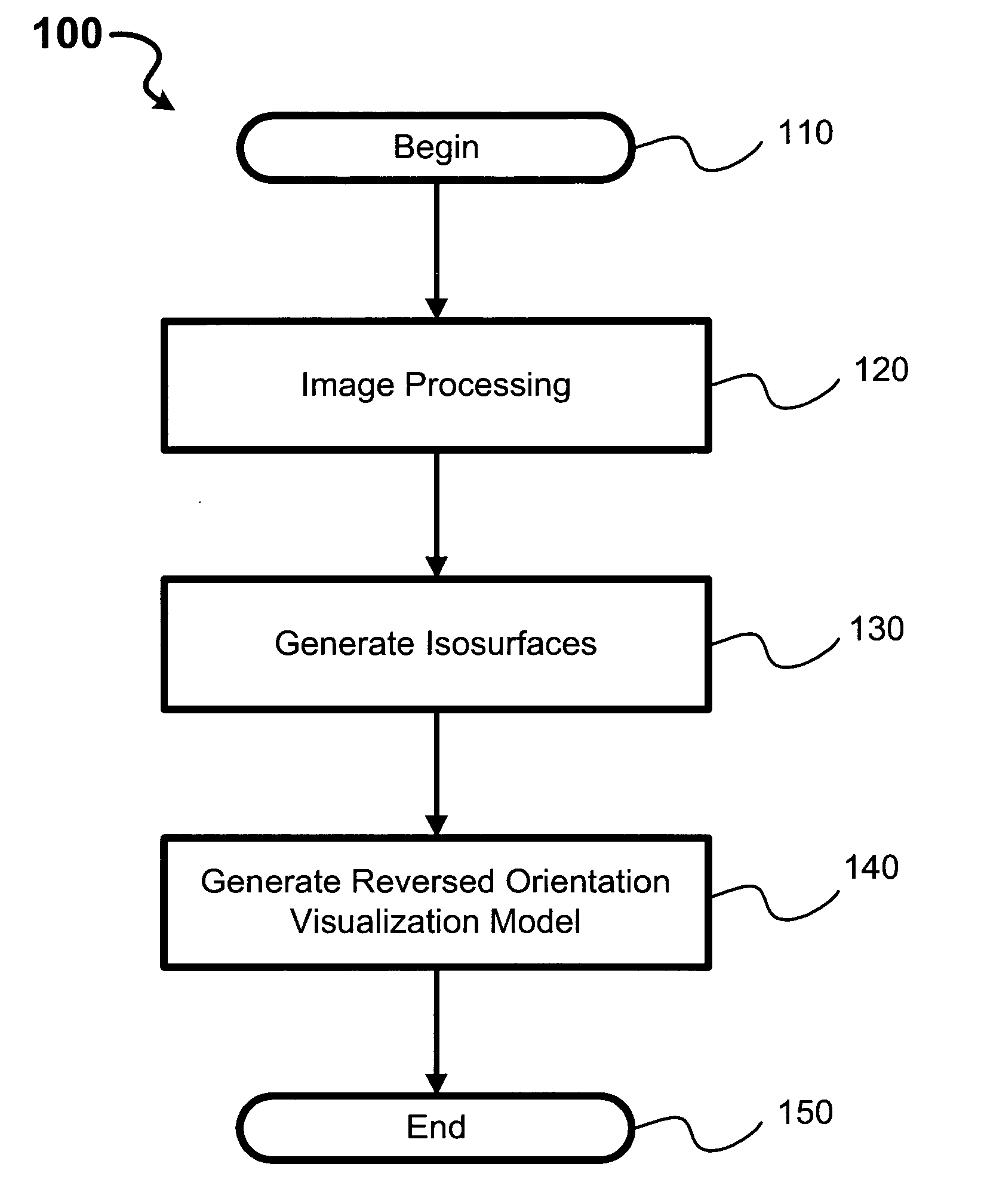
[0020] Referring now to FIG. 1, a routine 100 according to one presently preferred embodiment of the present invention includes three processes facilitating detection of an object in a point cloud of three-dimensional imaging data. The data is colle...


PUM


Abstract

Methods, computer-readable media, and systems for facilitating detection of an object in a point cloud of three-dimensional imaging data representing an area of study where the object potentially is obscured by intervening obstacles are provided. The imaging data is processed to identify elements in the point cloud having substantially common attributes signifying that the identified elements correspond to a feature in the area of study. An isosurface is generated associating the elements having substantially common attributes. A reversed orientation visualization model for a region of interest is generated. The reversed orientation visual model exposes areas of total occlusion that potentially signify presence of the object.

Description

GOVERNMENT LICENSE RIGHTS [0001] This invention was made with Government support under U.S. Government contract DAAD17-01-C-0074 A001 awarded by Defense Advanced Research Projects Agency (“DARPA”). The Government has certain rights in this invention.FIELD OF THE INVENTION [0002] This invention relates generally to radar systems and, more specifically, to improving detection of partially obstructed targets using line-of-sight imaging technologies. BACKGROUND OF THE INVENTION [0003] Over the past several decades, radar and similar imaging technologies have greatly improved. For example, the advent of three-dimensional laser detection and ranging (ladar) systems has greatly increased the ability to detect objects of interest by generating imaging data with much greater resolution than was possible with predecessor technologies. A ladar device is capable of digitizing as much as a gigapoint—one billion points—for a single scene. Such high resolution potentially vastly improves the possi...

Claims


Application Information

Patent Timeline
24 Mar 2005
Publication
US20050063593A1
IPC
G06K9/32; G06K9/46
CPC
G06K9/3241; G06V10/255
Inventors
NELSON, JAMES M.