Rapid mobility analysis and vehicular route planning from overhead imagery

a technology of overhead imagery and mobility analysis, applied in the field of ground vehicle mobility, can solve the problems of limited mobility of ground vehicles, especially unmanned ground vehicles, and difficulty in computer-based cognition of obstacles, and achieve the effects of reducing the number of obstacles

Inactive Publication Date: 2005-09-08
LOCKHEED MARTIN CORP
View PDF11 Cites 114 Cited by
  • Summary
  • Abstract
  • Description
  • Claims
  • Application Information

AI Technical Summary

Problems solved by technology

The mobility of ground vehicles, and particularly unmanned ground vehicles (“UGVs”), may be limited by many factors.
This is known as “route planning.” Human cognition of obstacles and identification of paths through obstacles is exceedingly difficult to replicate with computers.
Even with remotely operated vehicles, where a driver actively selects a route, high performance can be hampered by a general inability to accurately present to the driver the current situation in which the vehicle is operating.
However, in adverse conditions or without good quality video, the decision may be more difficult.
Mobility of military vehicles, in particular, presents additional problems.
Military vehicles are frequently expected to traverse unimproved terrain that may include large numbers of random obstacles.
Furthermore, conditions may change rapidly as combat obliter

Method used


Image

  • Rapid mobility analysis and vehicular route planning from overhead imagery
  • Rapid mobility analysis and vehicular route planning from overhead imagery
  • Rapid mobility analysis and vehicular route planning from overhead imagery

Examples


Embodiment Construction

[0044] Illustrative embodiments of the invention are described below. In the interest of clarity, not all features of an actual implementation are described in this specification. It will of course be appreciated that in the development of any such actual embodiment, numerous implementation-specific decisions must be made to achieve the developers' specific goals, such as compliance with system-related and business-related constraints, which will vary from one implementation to another. Moreover, it will be appreciated that such a development effort, even if complex and time-consuming, would be a routine undertaking for those of ordinary skill in the art having the benefit of this disclosure.

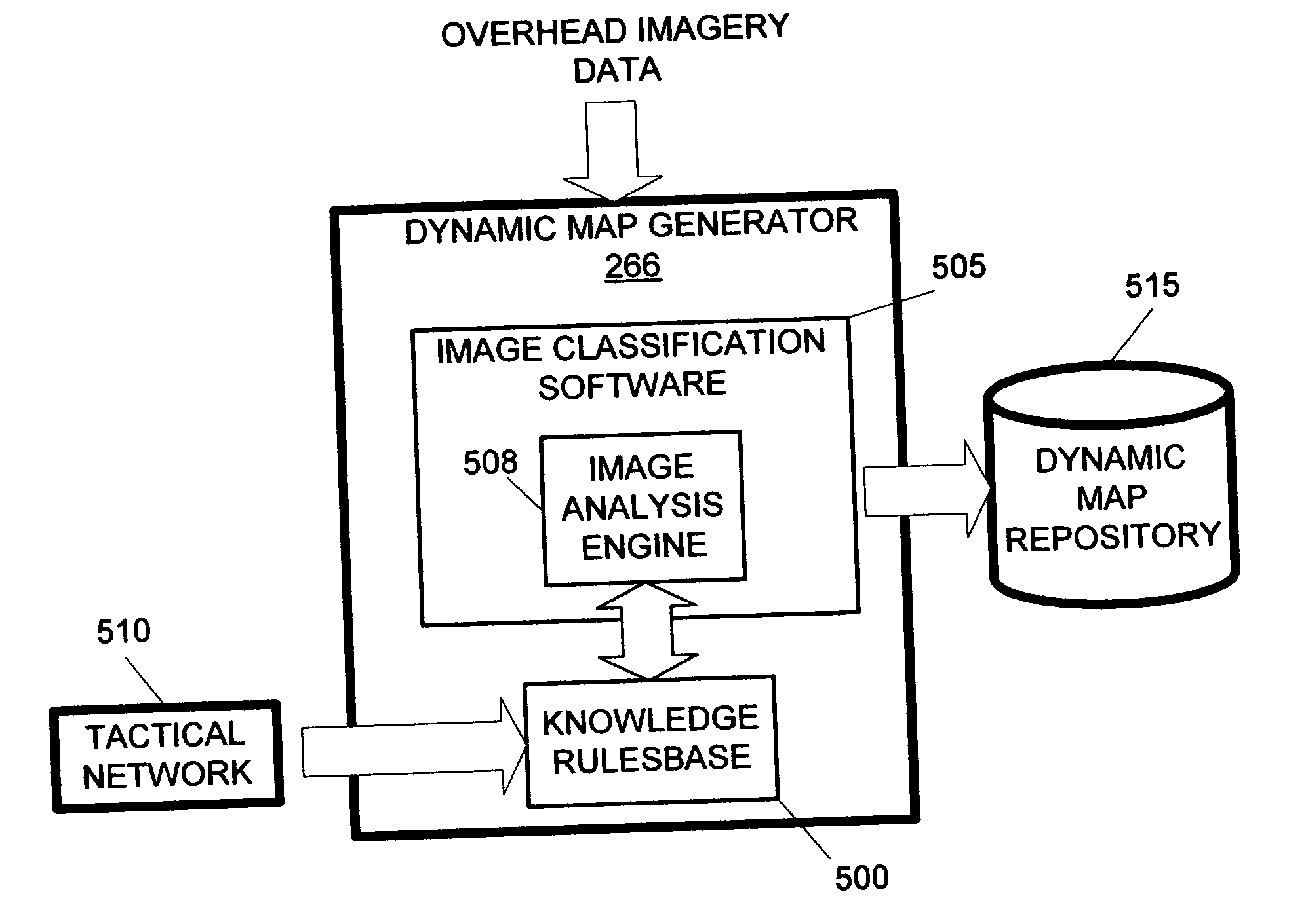
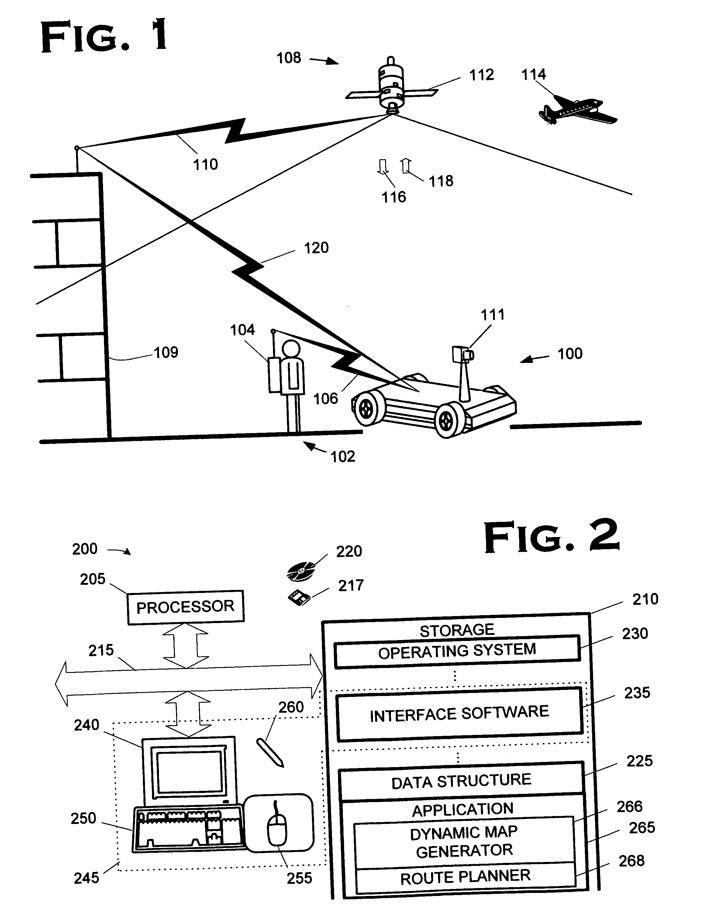
[0045]FIG. 1 depicts a ground vehicle 100 constructed and operated in accordance with one particular embodiment of the present invention. The ground vehicle 100 is, in the illustrated embodiment, an unmanned ground vehicle (“UGV”), although the invention is not so limited. The ground vehicle 10...


PUM


Abstract

The invention comprises, in its various embodiments and aspects, a method and apparatus for generating a dynamic mobility map. The method includes classifying a plurality of objects represented in a data set comprised of overhead imagery data; and classifying the objects through application of dynamic data pertaining to those objects. The apparatus includes a program storage medium encoded with instructions that, when executed by a computing device, perform such a method and a computing apparatus programmed to perform such a method. The method, in alternative embodiments, may be employed in generating dynamic mobility maps and in association with a ground vehicle to operate the vehicle or simulate the operation of the vehicle.

Description

BACKGROUND OF THE INVENTION [0001] 1. Field of the Invention [0002] This invention pertains to ground vehicle mobility and, more particularly, to a method and apparatus for navigating a ground vehicle. [0003] 2. Description of the Related Art [0004] The mobility of ground vehicles, and particularly unmanned ground vehicles (“UGVs”), may be limited by many factors. One significant factor is “situational awareness.” Situational awareness includes detection and identification of conditions in the surrounding environment. Robotic vehicles, for example, typically carry a variety of instruments to remotely sense the surrounding environment. Commonly used instruments include technologies such as: [0005] acoustic; [0006] infrared, such as short wave infrared (“SWIR”), long wavelength infrared (“LWIR”), and forward looking infrared (“FLIR”); [0007] optical, such as laser detection and ranging (“LADAR”). This list is not exhaustive, and a variety of technologies may be employed. Sometimes, s...

Claims


Application Information

Patent Timeline
IPC IPC(8): G01C21/32
CPCG01C21/32G01C21/005G01C21/3852G01C21/3826G01C21/3867
Inventor WARD, DEREK K.WALLOCH, MARGARET K.
Owner LOCKHEED MARTIN CORP
Why Eureka
Try Eureka