Secondary map in digital mapping system

a digital mapping and second map technology, applied in the field of digital mapping systems, can solve the problems that the area outside the zoomed area cannot be scened or otherwise referenced by the user, and limit the amount of flexibility available to the user

Active Publication Date: 2006-06-29
GOOGLE LLC
View PDF85 Cites 380 Cited by
  • Summary
  • Abstract
  • Description
  • Claims
  • Application Information

AI Technical Summary

Benefits of technology

[0007] One embodiment of the present invention provides a digital mapping method that includes displaying a main map and a secondary map, wherein upon being enabled, the secondary map is displayed within space previously occupied by the main map. The method may further include adjusting zoom level of the secondary map independently of main map zoom level, and / or resizing the secondary map in response to user input. In one particular case, upon the secondary map being disabled, the method further includes removing the secondary map from display and displaying the main map over space previously occupied by the secondary map. The method may include maintaining a relative zoom level difference between the main map and the secondary map when allowed by zoom level limits, as zoom level of the main map is adjusted. In one such case, if the relative zoom level difference cannot be maintained due to a zoom level limit associated with the secondary map, the method further includes automatically reinstating the relative zoom level difference when the secondary map zoom level limit is no longer a limit due to main map zoom level changes. The method may include displaying a viewing frame on one of the main map or the secondary map, wherein the map that has the viewing frame shows a geographic area that is larger than geographic area shown by the other map. The method can be programmed or otherwise configured, for example, to enable each of the main map and the secondary map to be independently set to one of a traditional type, satellite type, or hybrid type map.

Problems solved by technology

Thus, when a user is zoomed on a particular map area, areas outside that zoomed area cannot be scene or otherwise referenced by the user.
However, if the user does not know which direction to pan, then the user will have to zoom out first, until the desired map area is in view, and then zoom back on that desired area.
In this sense, a single view map limits the amount of flexibility available to the user.

Method used


Image

  • Secondary map in digital mapping system
  • Secondary map in digital mapping system
  • Secondary map in digital mapping system

Examples


Embodiment Construction

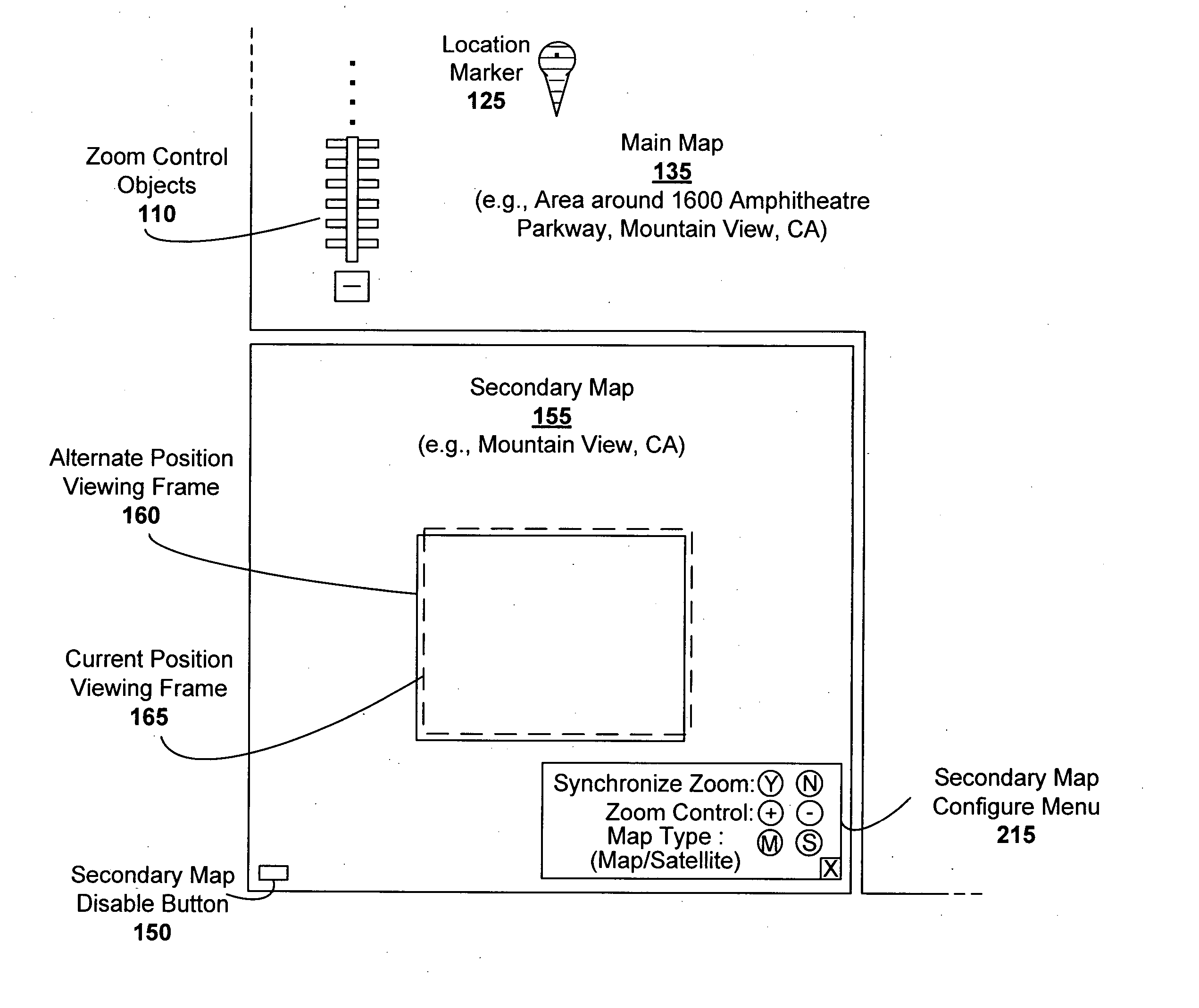
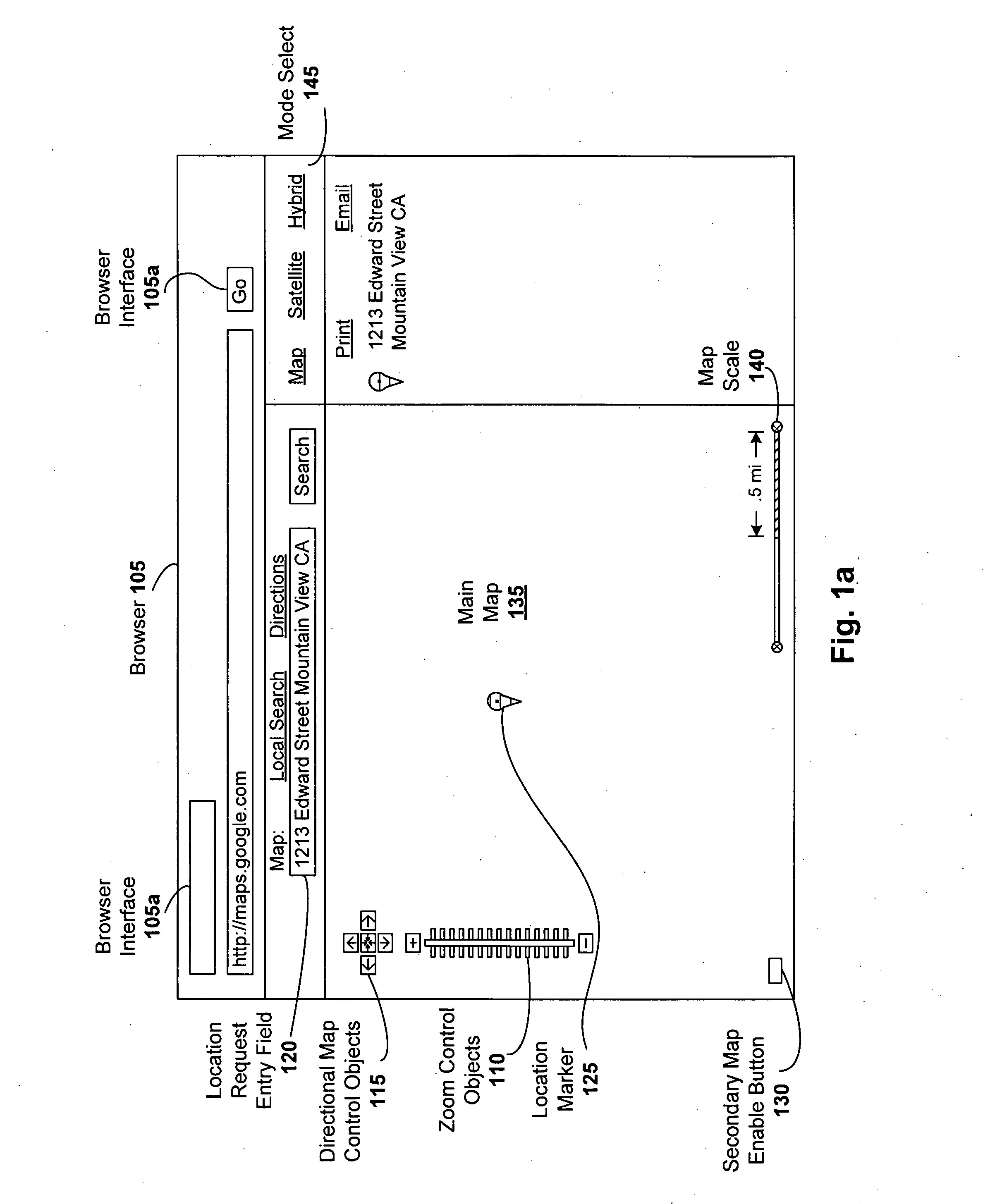
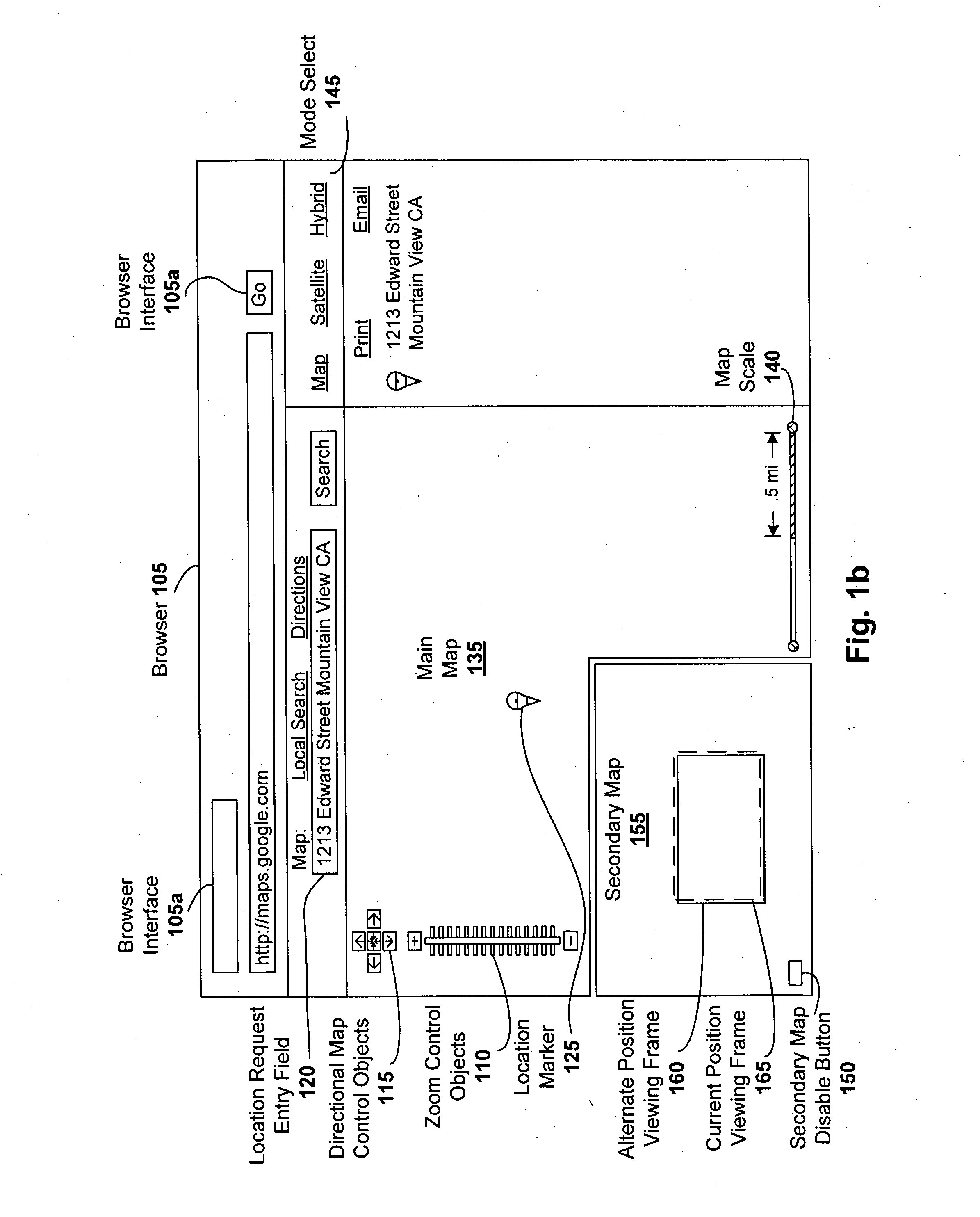
[0019] Digital mapping techniques are disclosed that provide more flexibility to the user through the use of multiple views of map information, including a main map and a secondary map, which can be located, for instance, in a corner of the main map.

[0020] The secondary map can provide the user with either a zoomed out map view (relative to the main map) for orientation (e.g., so as to enable informed panning), a zoomed in map view for specific area details, or a different type of map view relative to the main map view (e.g., main map can be a traditional drawn map and secondary map can be a satellite image or a hybrid of both traditional drawn map and satellite images). The secondary map can be turned on and off by the user. In cases where the secondary map shows a larger geographic area than the main map, the secondary map may include one or more viewing frames. For instance, one viewing frame may show the current position of the main map view, and another viewing frame can show ...


PUM


Abstract

Digital mapping techniques are disclosed that provide more flexibility to the user through the use of multiple views of map information, including a secondary map and a main map. The secondary map can provide the user with either a zoomed out or in relative to the main map, or a different type of map view (e.g., satellite images). The secondary map can be turned on and off by the user. The secondary map may include one or more viewing frames that indicate views (e.g., current and alternate views) of the main map. The user can move the main map, viewing frame, or secondary map to achieve desired map views. During such movement, the relationship between the main and secondary maps can be synchronous, partially synchronous, or serial.

Description

RELATED APPLICATIONS [0001] This application is a continuation-in-part of U.S. application Ser. No. 11 / 051,534, filed Feb. 5, 2005, titled “A Digital Mapping System”, which claims the benefit of U.S. Provisional Application No. 60 / 567,946, filed May 3, 2004, and 60 / 555,501, filed Mar. 23, 2004. In addition, this application is related to U.S. application Ser. No. 11 / 088,542, filed Mar. 23, 2005, titled “Generating and Serving Tiles in a Digital Mapping System”. Each of these applications is herein incorporated in its entirety by reference.FIELD OF THE INVENTION [0002] The invention relates to digital mapping systems, and more particularly, to an secondary map that can be synchronized with a main map to improve user experience. BACKGROUND OF THE INVENTION [0003] Computerized mapping systems have been developed to search for, identify, and discover information about geographic locations. One form of such computerized mapping systems includes travel-planning Internet websites. With an ...

Claims


Application Information

Patent Timeline
Patent Type & Authority Applications(United States)
IPC IPC(8): G09G5/00G01C21/32G01C21/36G06F17/30G09B29/10
CPCG01C21/32G01C21/367G06F3/0481G06F17/30241G06F17/3087G06F2203/04806G06T17/05G09B29/10G06F16/29G06F16/9537
Inventor RASMUSSEN, JENS EILSTRUPTAYLOR, BRET STEVENRASMUSSEN, LARS EILSTRUP
Owner GOOGLE LLC
Why Eureka
Try Eureka