Road map data generation method, road map data update system, and road map data management device

a technology of road map data and data management, applied in traffic control systems, navigation instruments, instruments, etc., can solve problems such as information retrieval problems, degraded efficiency in retrieving information within road map data, and discontinuous assignment of ids, and achieve the effect of effective updating of road map data

Inactive Publication Date: 2007-04-26
DENSO CORP
View PDF21 Cites 22 Cited by
  • Summary
  • Abstract
  • Description
  • Claims
  • Application Information

AI Technical Summary

Benefits of technology

[0018] It is an object of the present invention to provide an effective update of road map data.

Problems solved by technology

However, this results in discontinuous assignment of IDs by disregarding practical geographical arrangement of nodes and links.
Therefore, efficiency in retrieval of information within the road map data is degraded.
As a result, the above certain method poses the problem in information retrieval.
In this system, each of multiple combinations of road map data versions of neighboring divisional regions requires corresponding connection data, which complicates works for data generation.

Method used


Image

  • Road map data generation method, road map data update system, and road map data management device
  • Road map data generation method, road map data update system, and road map data management device
  • Road map data generation method, road map data update system, and road map data management device

Examples


first example

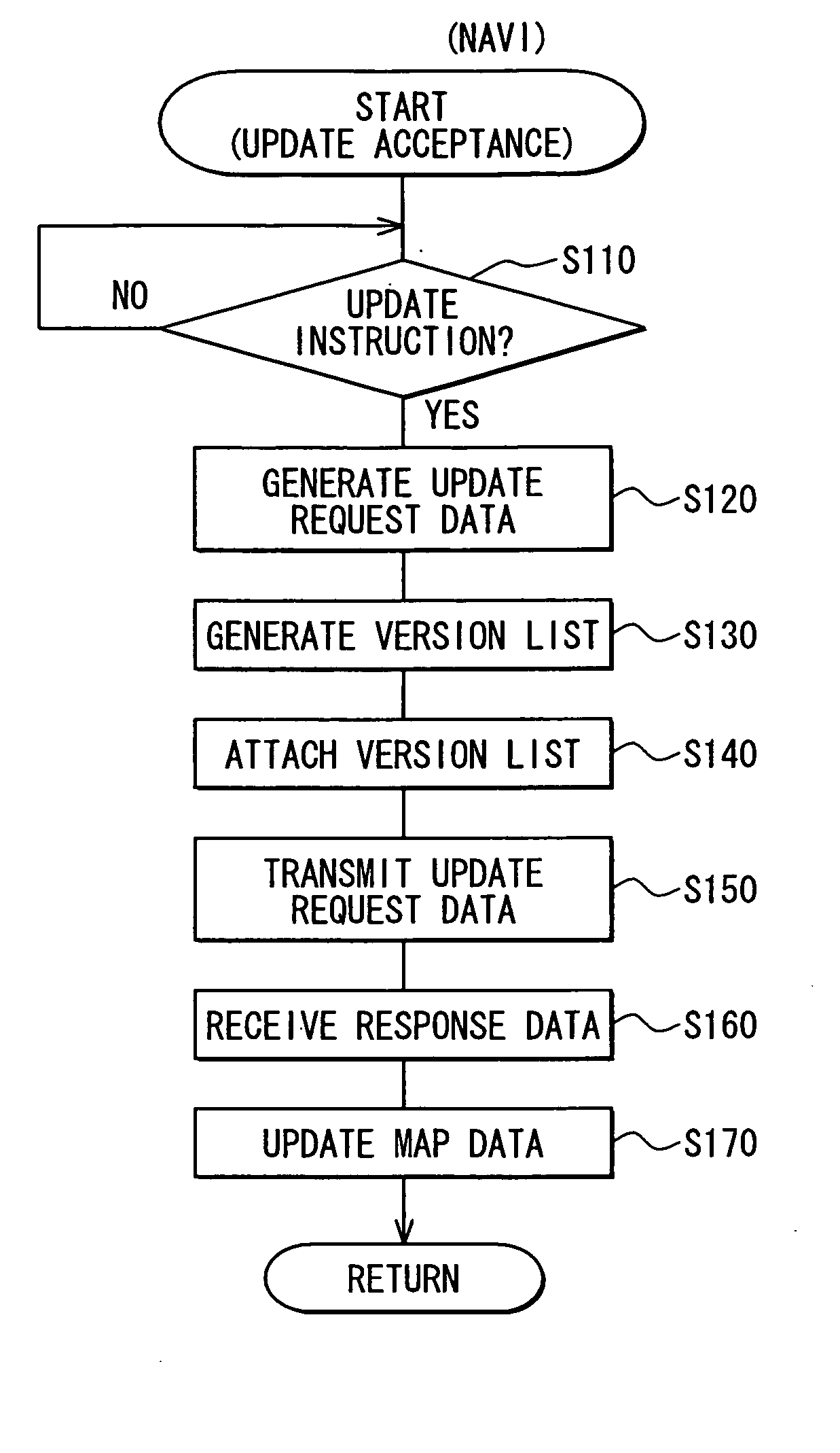
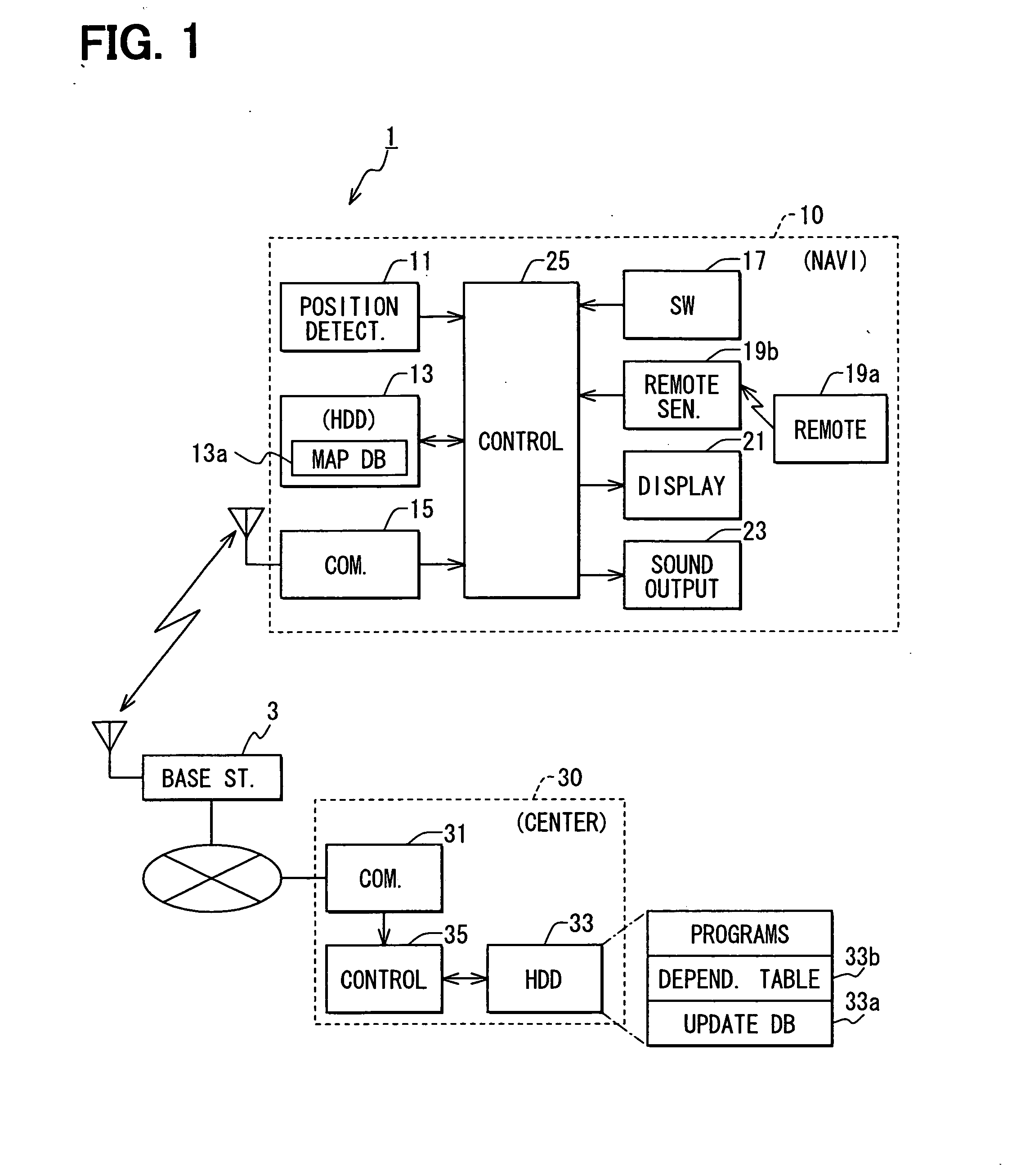
[0041] A road map data update system 1 as a first example of an embodiment according to the present invention will be explained below. As shown in FIG. 1, the road map data update system 1 includes navigation devices 10 and a center device 30 that updates a map database 13a in the navigation device 10. That is, the navigation device 10 may function as a communicating device to communicate with the center device 30 via a wireless base station 3 and also function a road map data management device to update the map database 13a, while the center device 30 may function as a update data provision device.

[0042] The navigation device 10 includes: a position detector 11, a hard disk device 13, a communicator 15, an operation switch group 17, a remote sensor 19b and remote 19a, a display unit 21, a sound output unit 23, and a control unit 25.

[0043] The position detector 11 includes a GPS receiver, which receives radio waves from artificial satellites for GPS (Global Positioning System) thr...

second example

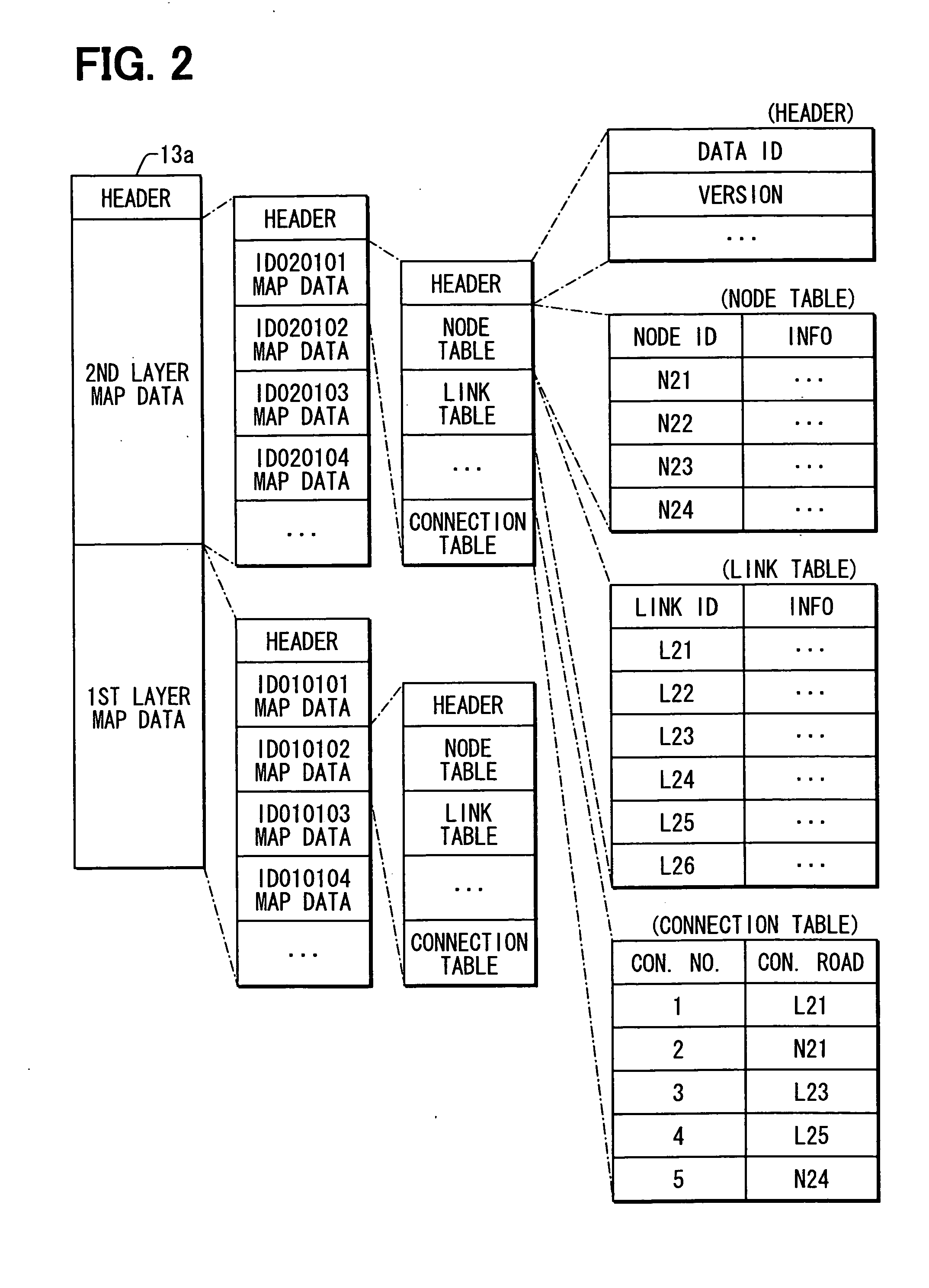
[0096] In the above first example, a connection table is assigned to each divisional region (or mesh); however, it can be assigned to each group of several divisional regions. For instance, as shown in FIG. 9, a group of regional map data items may be formed and each group can be assigned each connection table.

[0097] In this case, road connections of roads (nodes or links) within the group (within an area surrounded by heavy lines) are expressed in a manner (using characteristic information of nodes) similar to the conventional method. Roads connected at borders between the neighboring groups (links or nodes connected at the borders shown as heavy lines in FIG. 9) are expressed using a connection table to be further explained below. A modified map data update system as a second example will be explained with reference to FIGS. 9 to 12.

[0098] As shown in FIG. 9, in the modified map data update system, a group of map data is formed to incorporate map data corresponding to sixteen me...


PUM


Abstract

A navigation device has a regional map data item for each of multiple regions, into which a nation is divided. A connection table is included in a regional map data item for a certain region and associates (i) a certain ID of a connection road in the certain region with a certain connection number. The connection road is connected with a paired connection road in an adjacent region. A connection table of a regional map data item for the adjacent region associates an ID of the paired connection road with the same connection number as the certain connection number. When the certain ID in the certain region is replaced with a different ID because of a road construction or the like, only the certain ID is replaced in the connection table with the certain connection number unchanged. This eliminates need of amending the connection table for the adjacent region.

Description

CROSS REFERENCE TO RELATED APPLICATION [0001] This application is based on and incorporates herein by reference Japanese Patent Application No. 2005-291150 filed on Oct. 4, 2005. FIELD OF THE INVENTION [0002] The present invention relates to a road map data generation method, a road map data update system, and a road map data management device. BACKGROUND OF THE INVENTION [0003] A navigation device has road map data indicating road connections. The road connections can be expressed using link data and node data. [0004] The link data includes, with respect to a link, characteristic data such as a link ID identifying the link, coordinates of both ends of the link (road), a road type, a road length, and a road width. The node data includes, with respect to a node, characteristic data such as a node ID identifying the node, link IDs of links connected with the node, and a node type (e.g., intersection, fork, junction). In this road map data, road connections are expressed by assigning l...

Claims


Application Information

Patent Timeline
Patent Type & Authority Applications(United States)
IPC IPC(8): G01C21/32
CPCG01C21/32G09B29/007G01C21/3878G01C21/3896G01C21/3815G06F16/29G01C21/26G01C21/30G09B29/102
Inventor ATARASHI, YASUTAKA
Owner DENSO CORP
Why Eureka
Try Eureka