GPS route creation, photograph association, and data collection

Inactive Publication Date: 2008-04-03
AVAGO TECH WIRELESS IP SINGAPORE PTE
View PDF31 Cites 97 Cited by
  • Summary
  • Abstract
  • Description
  • Claims
  • Application Information

AI Technical Summary

Problems solved by technology

With this incorrect database information, the GPS navigation system may therefore provide directions to a non-desired location, provide an undesirable route, or otherwise function in an undesirab

Method used


Image

  • GPS route creation, photograph association, and data collection
  • GPS route creation, photograph association, and data collection
  • GPS route creation, photograph association, and data collection

Examples


first embodiment

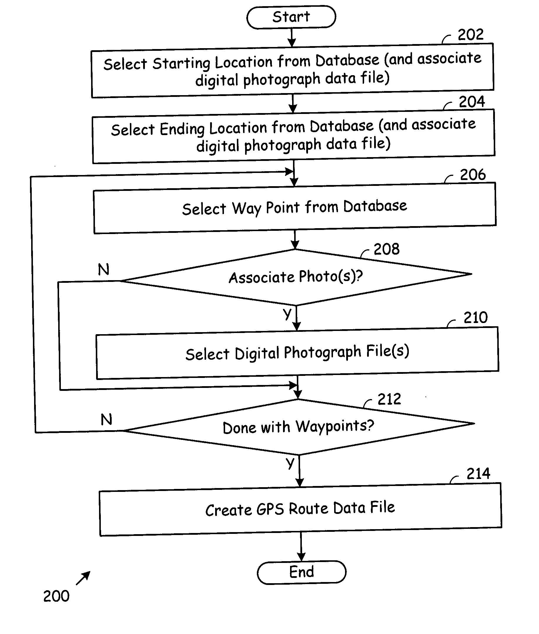
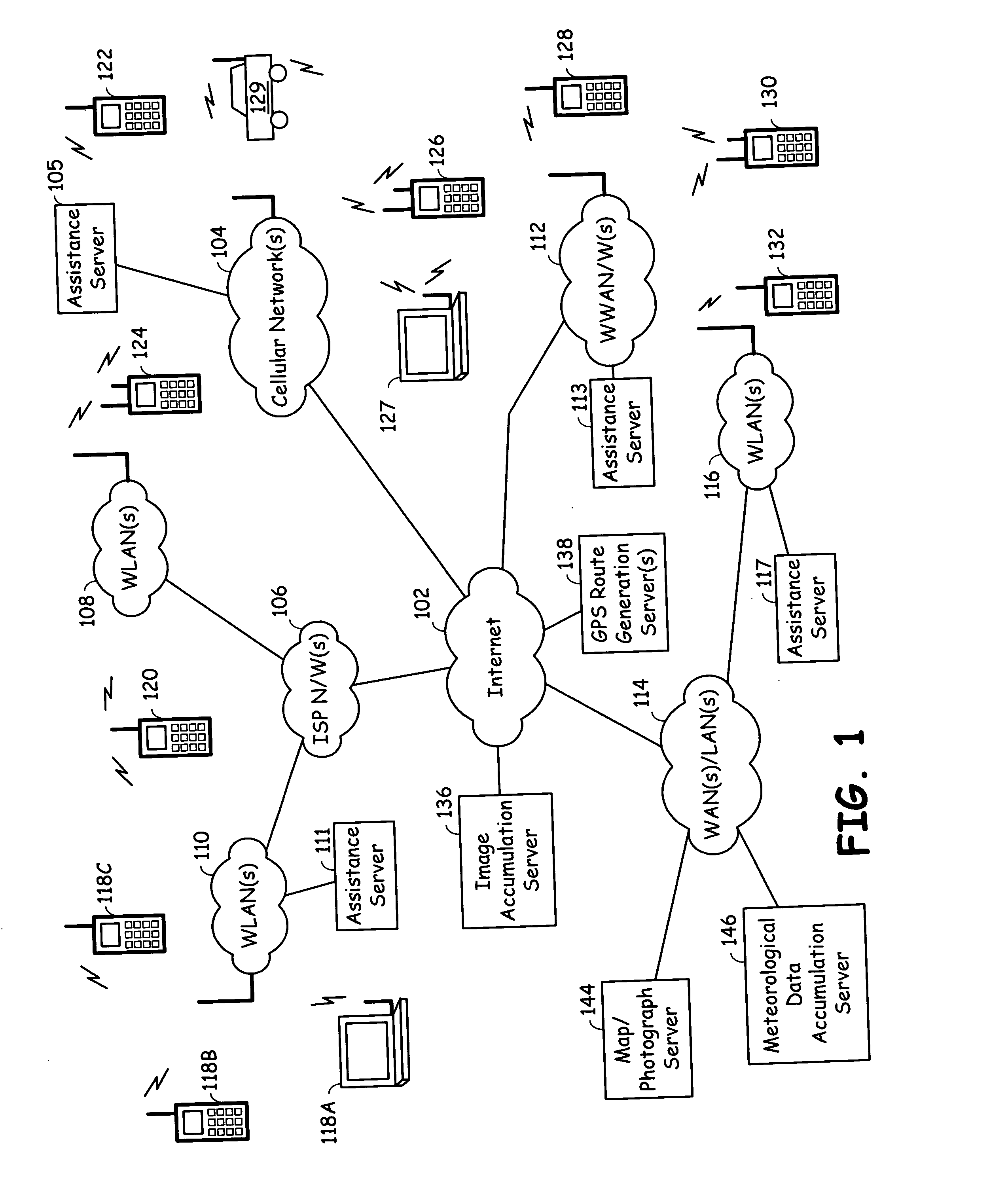
[0031]FIG. 2 is a flow chart illustrating GPS route generation operations according to the present invention. Generally, the operations 200 of FIG. 2 may be initiated by any client device that is communicatively coupled to the GPS route generation server 138 of FIG. 1. Thus, any of the wireless devices of FIG. 1 may communicate with GPS route generation server 138 to execute the operations 200 of FIG. 2 in cooperation with the GPS route generation sever 138. In addition, other digital computers that communicatively couple to the GPS route generation server 138 in a wired manner may also execute the operations 200 of FIG. 2. Further, a user local to the GPS route generation server 138 may also execute the operations 200 of FIG. 2 to generate a GPS route. A database referred to in the operations of FIG. 200 would be stored locally at the GPS route generation server 138 or at another location that is accessible to GPS route generation server.

[0032]The operations 200 of FIG. 2 commence ...

second embodiment

[0037]FIG. 3 is a flow chart illustrating GPS route generation operations according to the present invention. As compared to the operations 200 of FIG. 2, the operations 300 of FIG. 3 are employed by a user of a wireless terminal while traveling along a route for which the user desires to create the GPS route. As will be described further with reference to FIG. 7, a user of wireless terminal may desire to create driving instructions or a guided tour for use by his or her friends or business associates. In such case, the user of the wireless terminal would take the wireless terminal along a desired route.

[0038]The user of the wireless terminal would commence operation by providing user input to the wireless terminal to indicate presence at a starting location (Step 302). In response thereto, the wireless terminal would determine starting location GPS coordinates (Step 304). The wireless terminal would then store a starting location identifier and the starting location GPS coordinates...


PUM


Abstract

Global Positioning System (GPS) route creation via server interaction or wireless terminal collection creates a GPS route data file that includes starting location GPS coordinates, ending location GPS coordinates, and at least one way point location data element. Each way point location data element includes respective way point location GPS coordinates and a respective link to a corresponding digital photograph data file. Wireless terminals having corresponding sensors collect local meteorological conditions that are associated with digital photographs and GPS coordinates at capture. The digital photographs, GPS coordinates at capture, and local meteorological conditions are used to produce local weather reports for requesting client terminals. Virtual tours could also be conducted using the captured digital photograph files.

Description

CROSS REFERENCES TO RELATED APPLICATIONS[0001]The present application claims priority to Provisional Application Ser. No. 60 / 843,661 filed on Sep. 11, 2006, the disclosure of which is incorporated herein in its entirety by reference for all purposes.BACKGROUND OF THE INVENTION[0002]1. Technical Field of the Invention[0003]This invention relates generally to mobile communications and Global Positioning System (GPS) operations.[0004]2. Description of Related Art[0005]Communication systems technology has advanced greatly over the last 10 years. Mobile communication systems are now ubiquitous and service literally billions of subscribers. Mobile communication systems include cellular communication networks, Wireless Local Area Networks (WLANs), Personal wireless Area Networks (PANs), Worldwide Interoperability for Microwave Access (WiMAX) networks, satellite communication networks, among other wireless communication networks. Currently, handheld devices, automobile-based communication s...

Claims


Application Information

Patent Timeline
IPC IPC(8): G01C21/00
CPCG01W1/02G01C21/20
Inventor HILL, RYANKARAOGUZ, JEYHANSESHADRI, NAMBIRAJAN
Owner AVAGO TECH WIRELESS IP SINGAPORE PTE
Why Eureka
Try Eureka