Methods and apparatus for overlaying non-georeferenced symbology on a georeferenced chart

a georeferenced chart and symbology technology, applied in the field of aircraft flight management system displays, can solve the problems of many binders, affecting the appearance of the aircraft, and affecting the flight experience, and still having certain drawbacks

Inactive Publication Date: 2008-05-01
HONEYWELL INT INC
View PDF17 Cites 25 Cited by
  • Summary
  • Abstract
  • Description
  • Claims
  • Application Information

AI Technical Summary

Benefits of technology

[0008]In another embodiment, by way of example only, a display system includes a processor and a display. The processor is adapted to receive georeferenced formatted data representing an electronic aeronautical chart, to receive and convert non-georeferenced flight hazard data into a georeferenced format, and operable, in response to receiving and converting, to supply one or more image rendering display commands. The display device is coupled to receive the image rendering display commands and operable, in response thereto, to simultaneously render the converted flight hazard data on the electronic aeronautical chart.

Problems solved by technology

Depending on the length and / or complexity of the flight path, the pilot may need to refer to hundreds of pages of aeronautical charts; thus, the flight bag may, consequently, be relatively heavy.
Additionally, in some cases, numerous binders may be needed, which may occupy a large volume of space onboard the aircraft.
Although the electronic versions have many advantages, they still have certain drawbacks.
In some cases, such as when an instantaneous flight operation decision may need to be made, it may be relatively burdensome for the pilot to process data obtained from two different displays or two different sources.

Method used


Image

  • Methods and apparatus for overlaying non-georeferenced symbology on a georeferenced chart
  • Methods and apparatus for overlaying non-georeferenced symbology on a georeferenced chart
  • Methods and apparatus for overlaying non-georeferenced symbology on a georeferenced chart

Examples


Embodiment Construction

[0013]The following detailed description is merely exemplary in nature and is not intended to limit the invention or the application and uses of the invention. Furthermore, there is no intention to be bound by any expressed or implied theory presented in the preceding technical field, background, brief summary or the following detailed description.

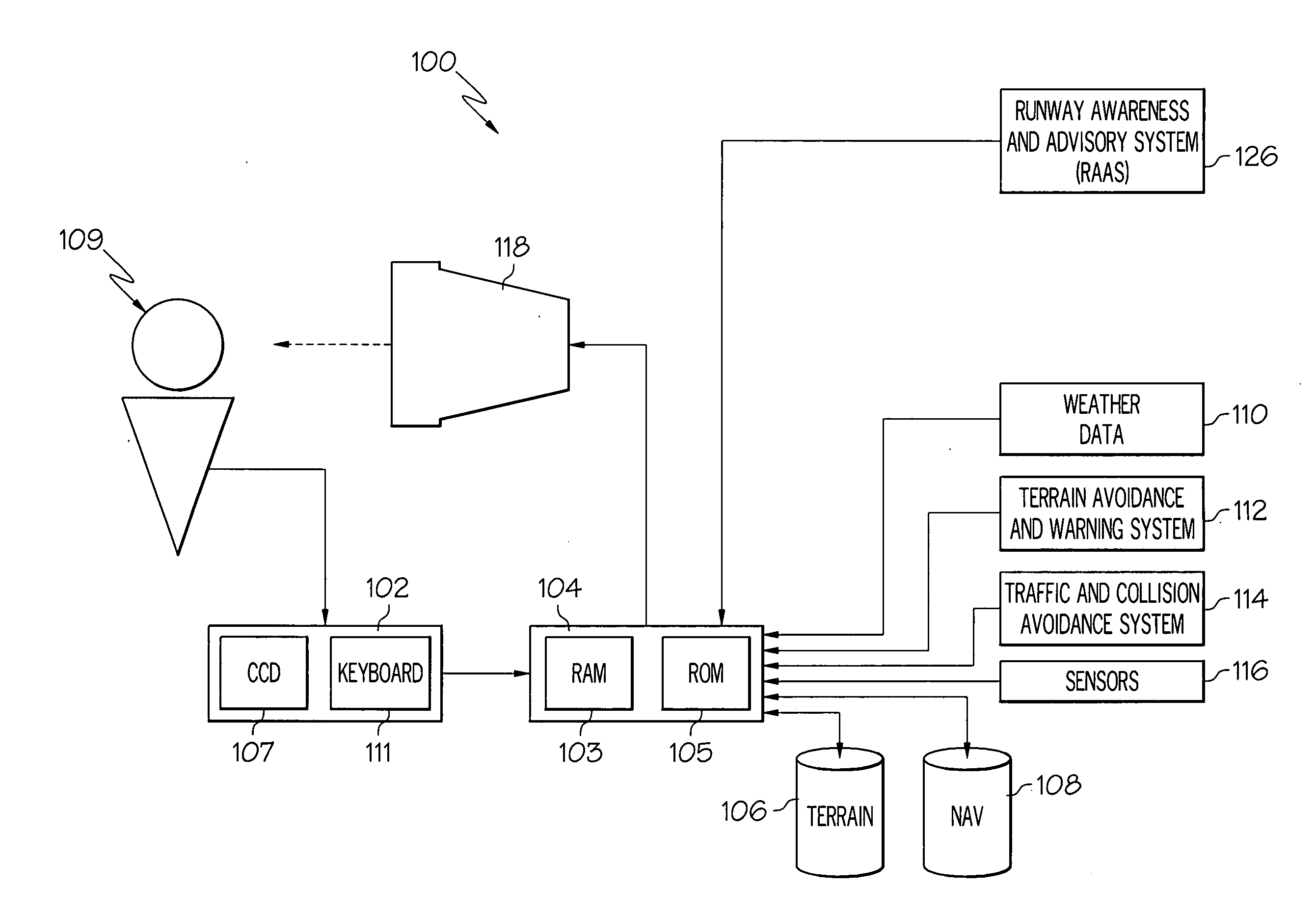
[0014]Turning now to the description, and with reference to FIG. 1, an exemplary flight deck display system will be described. The system 100 includes a user interface 102, a plurality of flight hazard detection sensors, a processor 104, and a display device 118. The user interface 102 is in operable communication with the processor 104 and is configured to receive input from a user 109 (e.g., a pilot) and, in response to the user input, supply command signals to the processor 104. The user interface 102 may be any one, or combination, of various known user interface devices including, but not limited to, a cursor control device (CCD) 107,...


PUM


Abstract

Methods and apparatus are provided for displaying flight hazard data on a display in an aircraft. In one embodiment, by way of example only, a method includes displaying an electronic aeronautical chart comprising georeferenced formatted data, converting non-georeferenced flight hazard data into a georeferenced format, and displaying the converted flight hazard data on the electronic aeronautical chart

Description

FIELD OF THE INVENTION[0001]The present invention generally relates to aircraft flight management system displays and, more particularly, to a flight management system display that overlays non-georeferenced symbology onto a georeferenced electronic aeronautical chart.BACKGROUND OF THE INVENTION[0002]Aeronautical charts include key information for use during an aircraft flight. For instance, aeronautical charts contain navigation information, such as airport map data, airport approach data, airspace data, and / or procedural information, such as airport departure and arrival procedure data. The charts are typically available in paper-form and disposed in a binder so that the information contained thereon, which frequently becomes obsolete, may be regularly replaced.[0003]Typically, each pilot is issued a flight bag within which the aeronautical chart binders are maintained. Before a flight, the pilot is responsible for physically updating the charts he may need during the flight and t...

Claims


Application Information

Patent Timeline
Patent Type & Authority Applications(United States)
IPC IPC(8): G01C23/00
CPCG01C23/005G09B29/007G08G5/0021
Inventor RATCLIFFE, THOMAS L.
Owner HONEYWELL INT INC
Why Eureka
Try Eureka