Navigation System And Portable Terminal

a portable terminal and navigation system technology, applied in navigation instruments, surveying and navigation, instruments, etc., can solve the problems of small display of maps, display means, and difficulty for users to see, and achieve the effect of superior safety

Inactive Publication Date: 2008-05-15
NAVITIME JAPAN CO LTD
View PDF14 Cites 58 Cited by
  • Summary
  • Abstract
  • Description
  • Claims
  • Application Information

AI Technical Summary

Benefits of technology

[0045]In the portable terminal of the invention according to the first and seventh aspects, the distance calculation means calculates the distance from the current position to the next guidance point, the image formation means prepares a background image and a guidance image that are displayed by the display means on the basis of route guidance data that is sent from the navigation server, and images in which the display colors of the background images are respectively set as different display colors in accordance with the distance calculated by the distance display means are prepared and displayed by the display means. Since the background images are images that occupy the largest display area in the screen layout of the display means, the user can instantaneously recognize the distance from the current position to the guidance point by the color of the background image displayed on the display screen, and the driver can instantaneously recognize the guidance image with a single glance.
[0046]In the invention according to the second and eighth aspects, the portable terminal has another operating mode that displays maps, and is provided with mode switching means. Accordingly, maps can be displayed together with the guidance route in the same manner as in an ordinary navigation system, and the user can grasp the geographical conditions of the guidance route prior to starting. Furthermore, the operating mode that displays these maps is used by the driver in a stopped state prior to starting, and there is no effect on the driving operation even if detailed maps are displayed. Furthermore, in this operating mode, the front seat passenger can also be used as the navigator.
[0047]In the invention according to the third through sixth and ninth through twelfth aspects, a structure is used in which automatic switching to the driving mode can be accomplished by various methods using a mode switching means installed in the portable terminal. Accordingly, in cases in which the user receives the navigation service of the portable terminal while driving, the system automatically switches to the driving mode. The system therefore operates in a display mode that displays no maps, and there is no interference with the driving operation. Accordingly, a navigation system and portable terminal that are superior in terms of safety can be provided.

Problems solved by technology

In communications navigation systems, especially in cases in which the terminal apparatus is a portable terminal such as a portable telephone or the like, the size of the display means is limited; accordingly, the display of maps is small, and the display is difficult for the user to see.
Furthermore, in cases in which guidance relating to guidance points is added as a character display, the display is even poorer in terms of visual recognition by the user.

Method used


Image

  • Navigation System And Portable Terminal
  • Navigation System And Portable Terminal
  • Navigation System And Portable Terminal

Examples


examples

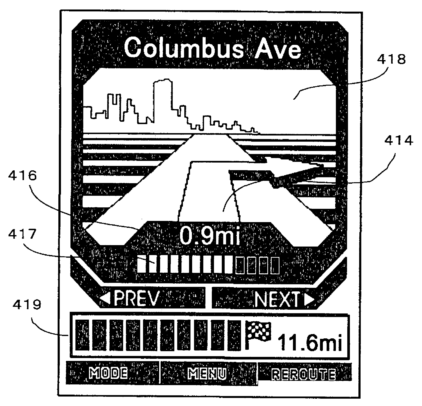
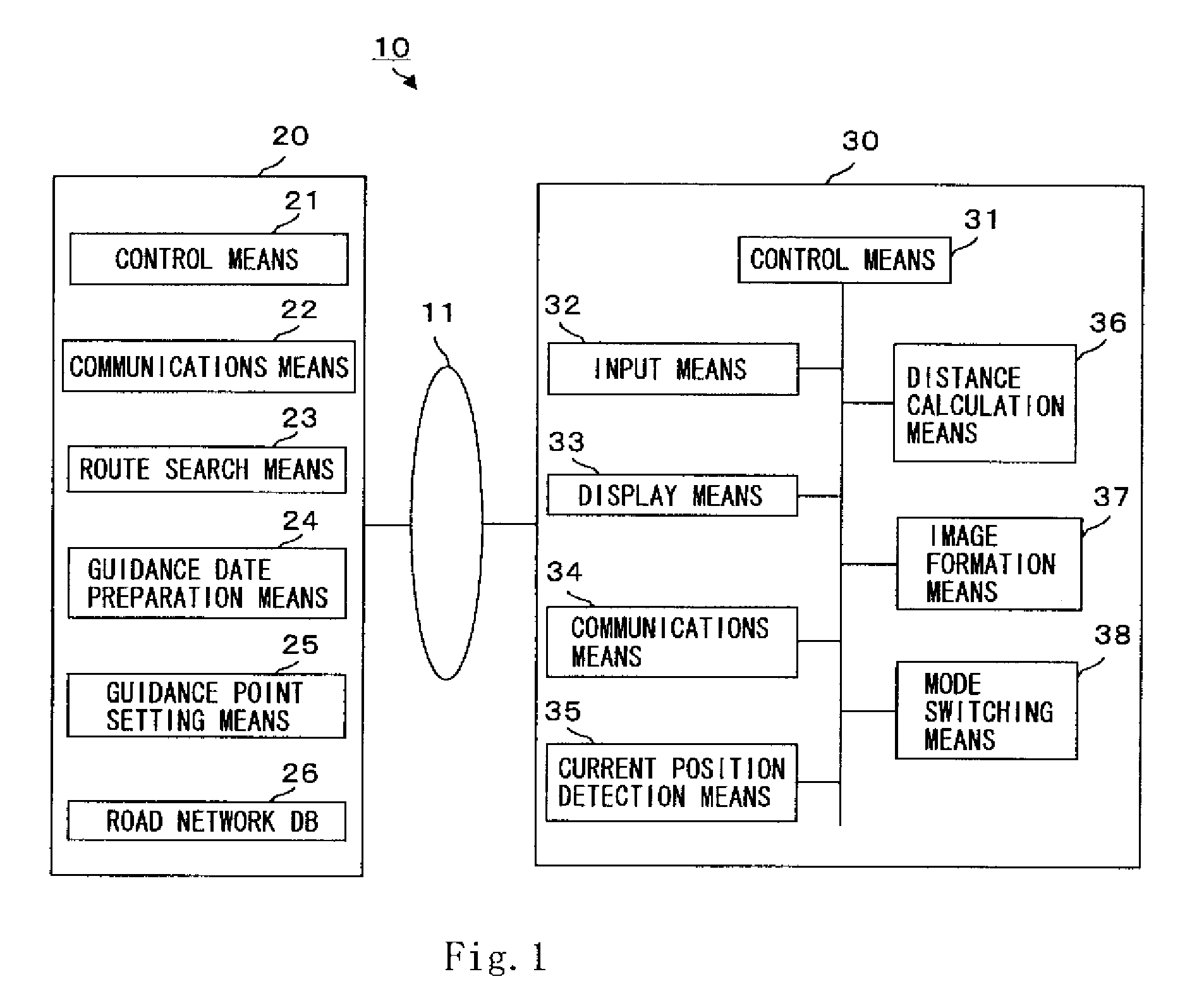
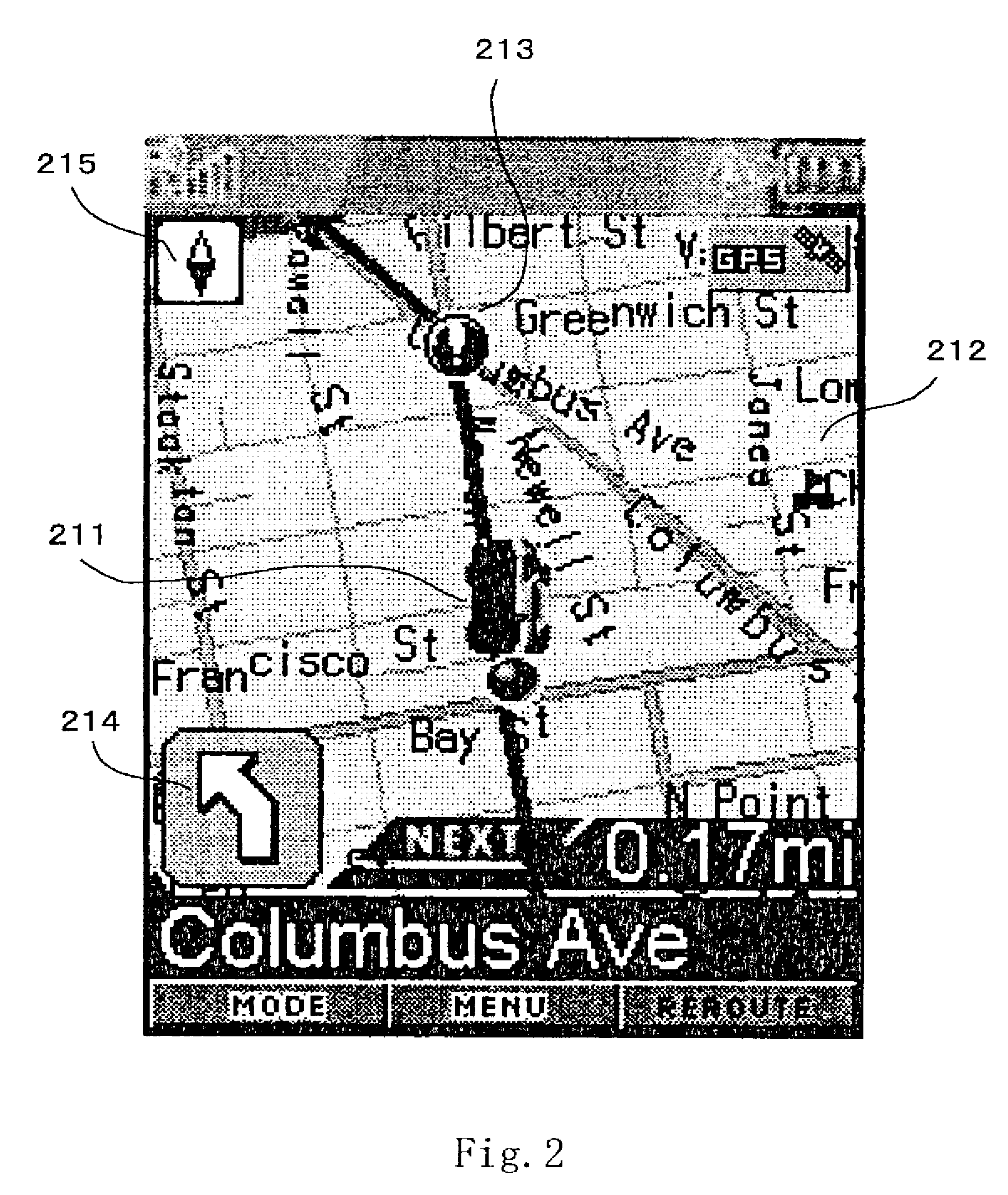
[0049]The navigation system 10 constituting an embodiment of the present invention comprises a portable terminal 30 and a navigation server 20 that communicate via a network 11 such as the Internet or the like. For example, a portable terminal such as a portable telephone or the like can be used as the portable terminal 30. The user transmits route search conditions such as the starting point, destination, starting time, arrival time, and the like from the portable terminal 30 to the navigation server 20. The navigation server 20 searches for the optimal route from the starting point to the destination in accordance with the route search conditions sent from the portable terminal 30, prepares data relating to the guidance route identified by the search, and transmits this data to the portable terminal 30. As in the Previous Application 1 described above, the guidance route data that is sent to the portable terminal 30 from the navigation server 20 comprises maps that include the cur...


PUM


Abstract

A navigation system of communication type enabling the user to recognize necessary information instantly without watching the display screen and a portable terminal are provided. A navigation server 20 creates data on a guidance path including a guidance point on the guidance path and guidance information on the guidance point according to a sought guidance path and sends the data to a portable terminal 30. The portable terminal 30 has a drive operating mode. When the portable terminal 30 operates in the drive mode, distance calculating means 36 calculates the distance from the current position to the next guidance point from the current position detected by current position detecting means 35 and the guidance path data sent from the navigation server 20, image creating means 37 creates a background image and a guidance image displayed on display means, and creates and displays an image where the display color of the background image varies depending on the distance calculated by the distance calculating means 36.

Description

TECHNICAL FIELD[0001]The present invention relates to a navigation system in which a route search is requested from a navigation server using a portable terminal such as a portable telephone or the like, and data concerning guidance routes and guidance points is received from the navigation server and displayed on the display screen of the portable terminal. More specifically, the present invention relates to a navigation system and portable terminal which are devised so that a display that can easily be visually recognized by the user is displayed on a portable terminal in which there are limitations on the size of the display screen, without displaying detailed maps or guidance routes.BACKGROUND ART[0002]In the past, navigation devices and navigation systems have been known which guide the user by searching for and finding routes from a desired starting point to a desired destination using map data and road data. Devices and systems that have been implemented as such navigation de...

Claims


Application Information

Patent Timeline
Patent Type & Authority Applications(United States)
IPC IPC(8): G01C21/34
CPCG01C21/20G01C21/3655G01C21/3626
Inventor YAMAZAKI, HIROSHITASHIRO, KAZUHIROYOSHIDA, MASAKAZU
Owner NAVITIME JAPAN CO LTD
Why Eureka
Try Eureka