Map information generating systems, methods, and programs

a technology of information generation system and map, applied in the field of map information generation system, can solve the problems of not recording, information relating to new roads, and huge amount of time required to survey all the necessary items in such a manner

Active Publication Date: 2008-07-03
AISIN AW CO LTD
View PDF6 Cites 41 Cited by
  • Summary
  • Abstract
  • Description
  • Claims
  • Application Information

AI Technical Summary

Benefits of technology

[0009]Exemplary implementations of the broad principles described herein provide a map information generating system that may prevent the generation of plural new road information in relation to a single road when the new road information is generated from the traveling locus of a vehicle.

Problems solved by technology

In this case, a problem arises in that information relating to new roads constructed after the map data of the navigation device have been generated is not recorded in the map information data.
However, an extremely large number of new roads are built every year, and therefore a huge amount of time is required to survey all of the necessary items in such a manner.
As a result, a considerable amount of time is required before new roads are reflected in the map data of the navigation device, leading to a reduction in the reliability of the navigation device.
More specifically, even when the vehicle travels along the same road a number of times, it is unlikely that the traveling loci will match completely, especially when the road has a plurality of lanes.
Moreover, deviations may occur among traveling loci due to detection errors.

Method used


Image

  • Map information generating systems, methods, and programs
  • Map information generating systems, methods, and programs
  • Map information generating systems, methods, and programs

Examples


Embodiment Construction

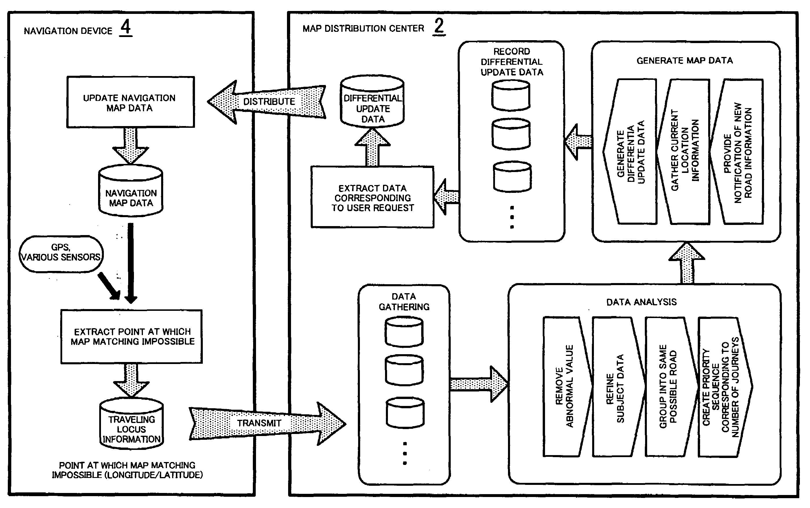
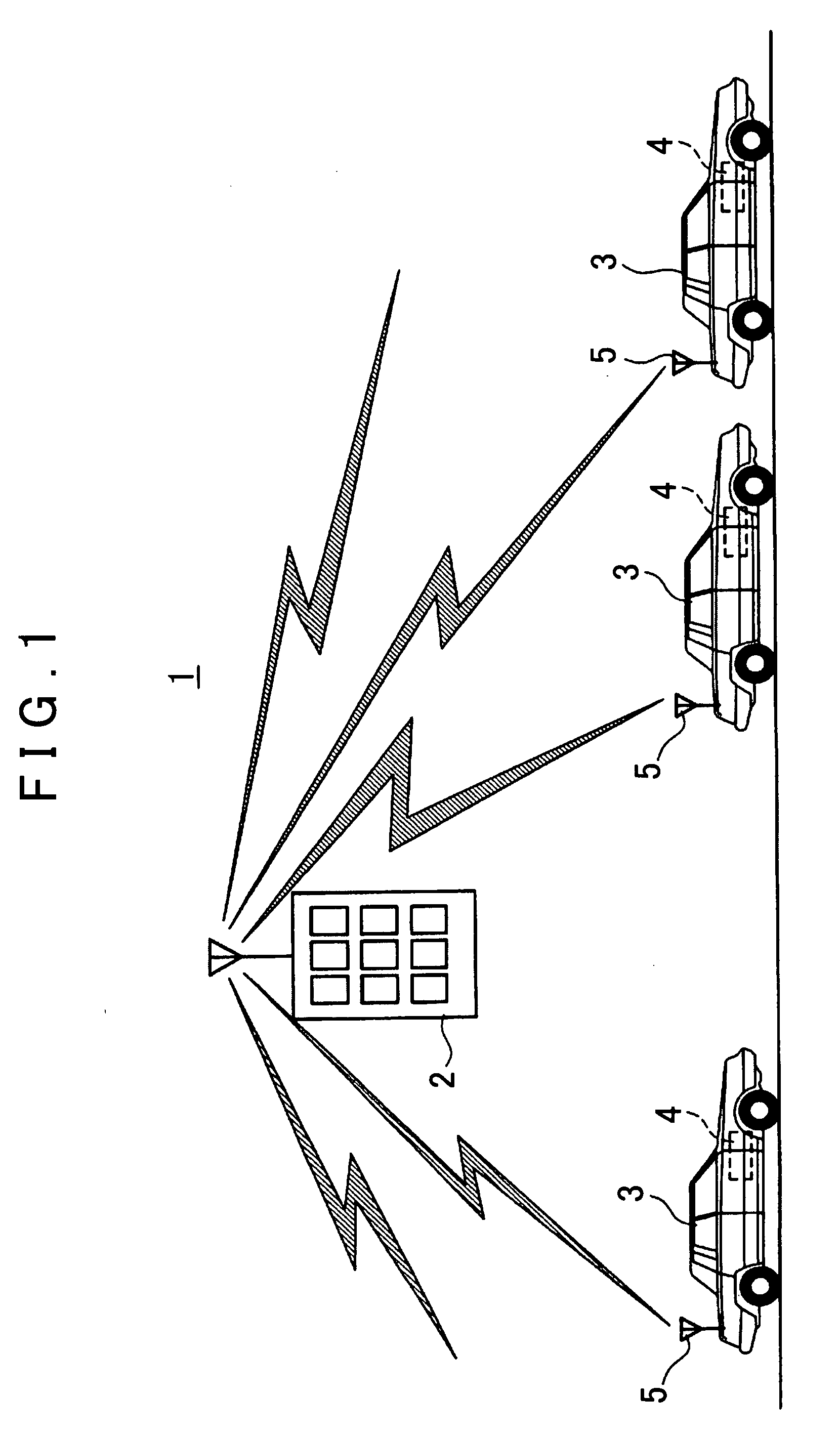
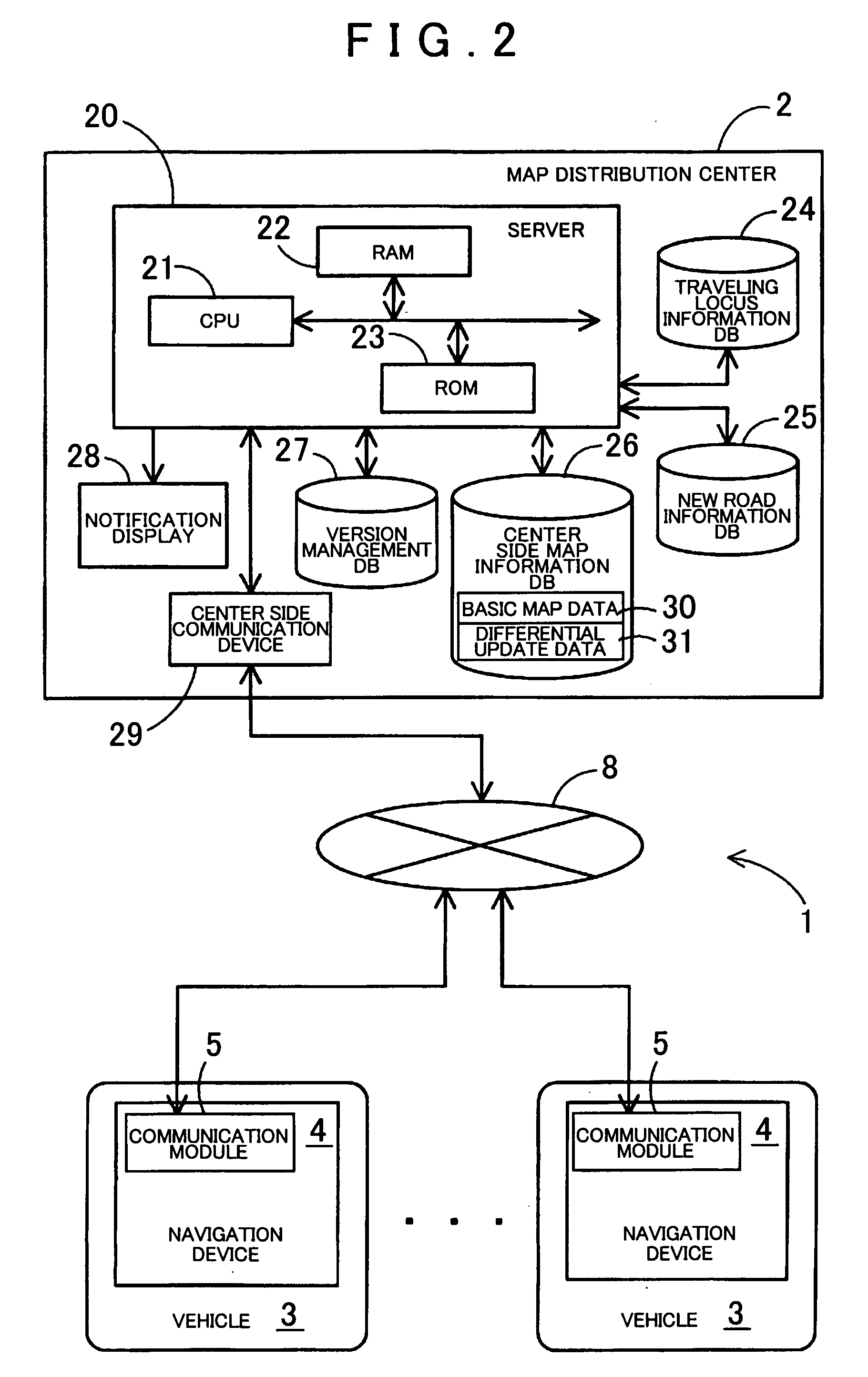
[0027]FIG. 1 is a schematic view showing an exemplary map information generating system 1. As shown in FIG. 1, the map information generating system 1 may physically, functionally, and / or conceptually, include a map distribution center 2, vehicles 3 serving as probe cars, and a navigation device 4 installed in each vehicle 3.

[0028]Here, the map distribution center 2 may gather and accumulate traveling locus information in the form of probe data transmitted from each of the vehicles 3 as they travel throughout the country. The map distribution center may generate new road information from the accumulated traveling locus information. The map distribution center 2 may refer to the generated new road information to generate update data for updating an old version of map data to a new version of the map data including the newly constructed new roads, and may distribute the generated update data.

[0029]Note that two types of update data may be used, namely full update data for overwriting ...


PUM


Abstract

Systems, methods, and programs store map information including a road network. The systems, methods, and programs gather traveling information including a plurality of loci, each locus representing a vehicle traveling along a road that is not included in the stored road network. The systems, methods, and programs separate the loci within the gathered traveling information into groups, each group related to a same road and generate new road information relating to a single new road for each group of loci.

Description

[0001]The disclosures of Japanese Patent Application No. 2006-352951, filed on Dec. 27, 2006, Japanese Patent Application No. 2006-353057, filed on Dec. 27, 2006, Japanese Patent Application No. 2006-352922, filed on Dec. 27, 2006, and Japanese Patent Application No. 2006-352908, filed on Dec. 27, 2006, including the specifications, drawings and abstracts are incorporated herein by reference in their entirety.BACKGROUND[0002]1. Related Technical Fields[0003]Related technical fields include map information generating systems. In particular, related technical fields include systems for generating new road information that is added to map information stored in a navigation device or the like.[0004]2. Related Art[0005]Navigation devices provide guidance for vehicles, enabling a driver to reach a desired destination easily. Such devices are capable of detecting the current position of a vehicle using a GPS receiver, obtaining map data corresponding to the current position from a recordin...

Claims


Application Information

Patent Timeline
Patent Type & Authority Applications(United States)
IPC IPC(8): G01C21/26
CPCG01C21/32G09B29/10G09B29/007G08G1/20G01C21/3844G01C21/3815G01C21/3841G01C21/3859
Inventor NAKAMURA, NORIHIRO
Owner AISIN AW CO LTD
Why Eureka
Try Eureka