

Apparatus and method using compressed codes for comprising latitude/longitude information
a technology of latitude/longitude and compressed codes, applied in direction finders using radio waves, navigation instruments, instruments, etc., can solve the problems of difficult to be exploited in many existing navigation equipment and systems, and the prior method of representing a geographical coordinate of an entity on the earth is not convenient to be recorded, so as to facilitate people's memory and manipulation
- Summary
- Abstract
- Description
- Claims
- Application Information
AI Technical Summary
Problems solved by technology
Method used
Image

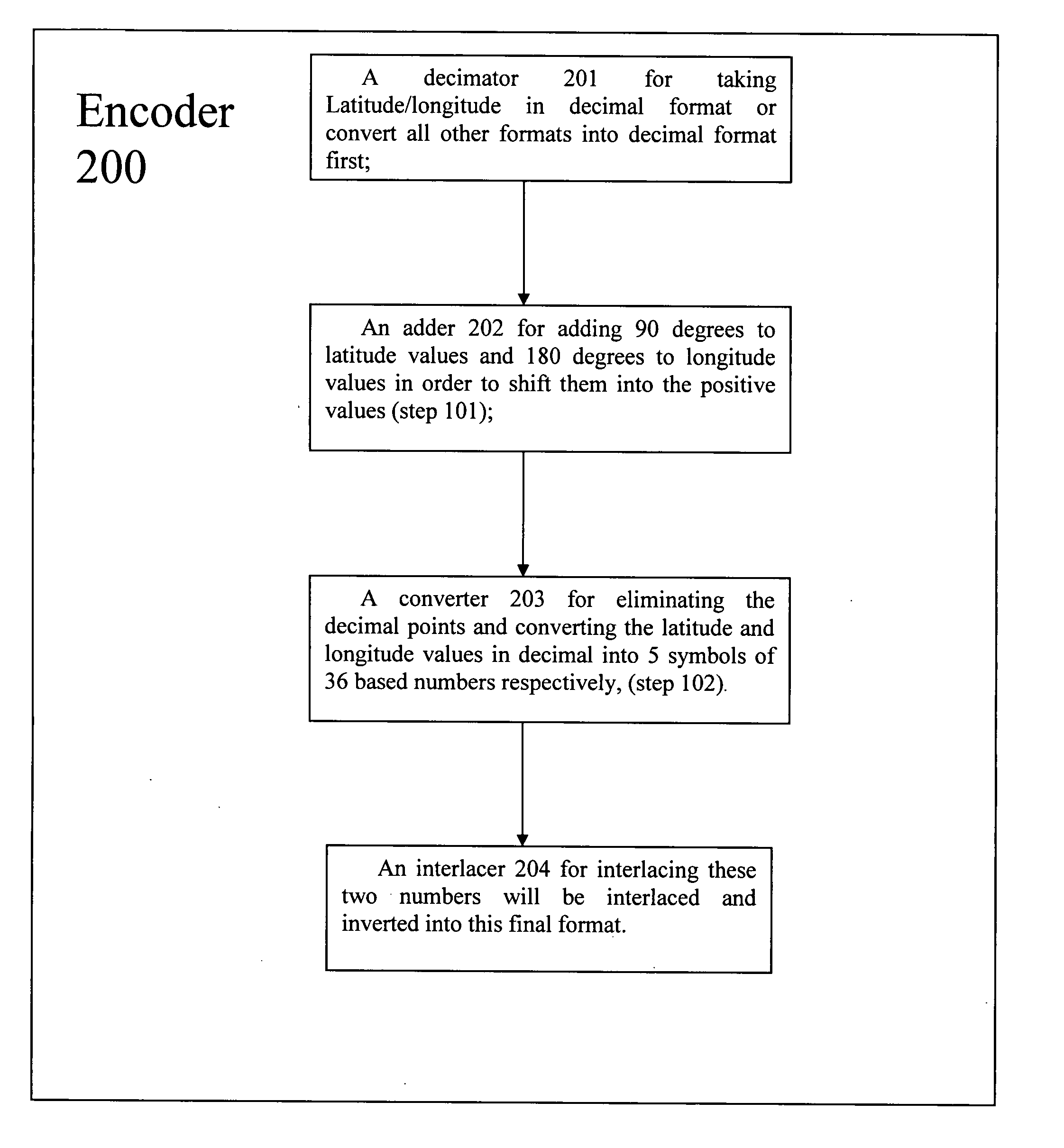
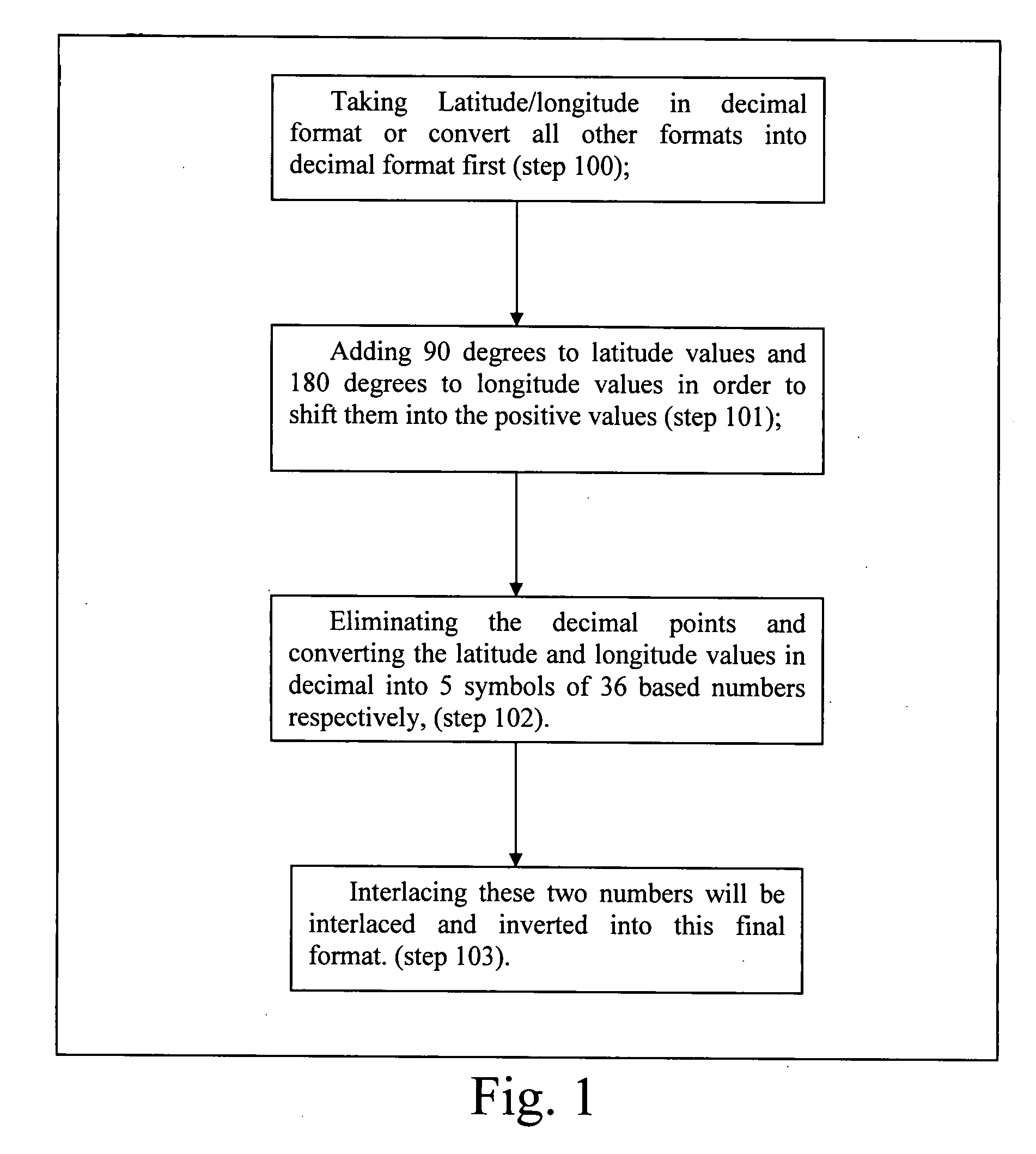
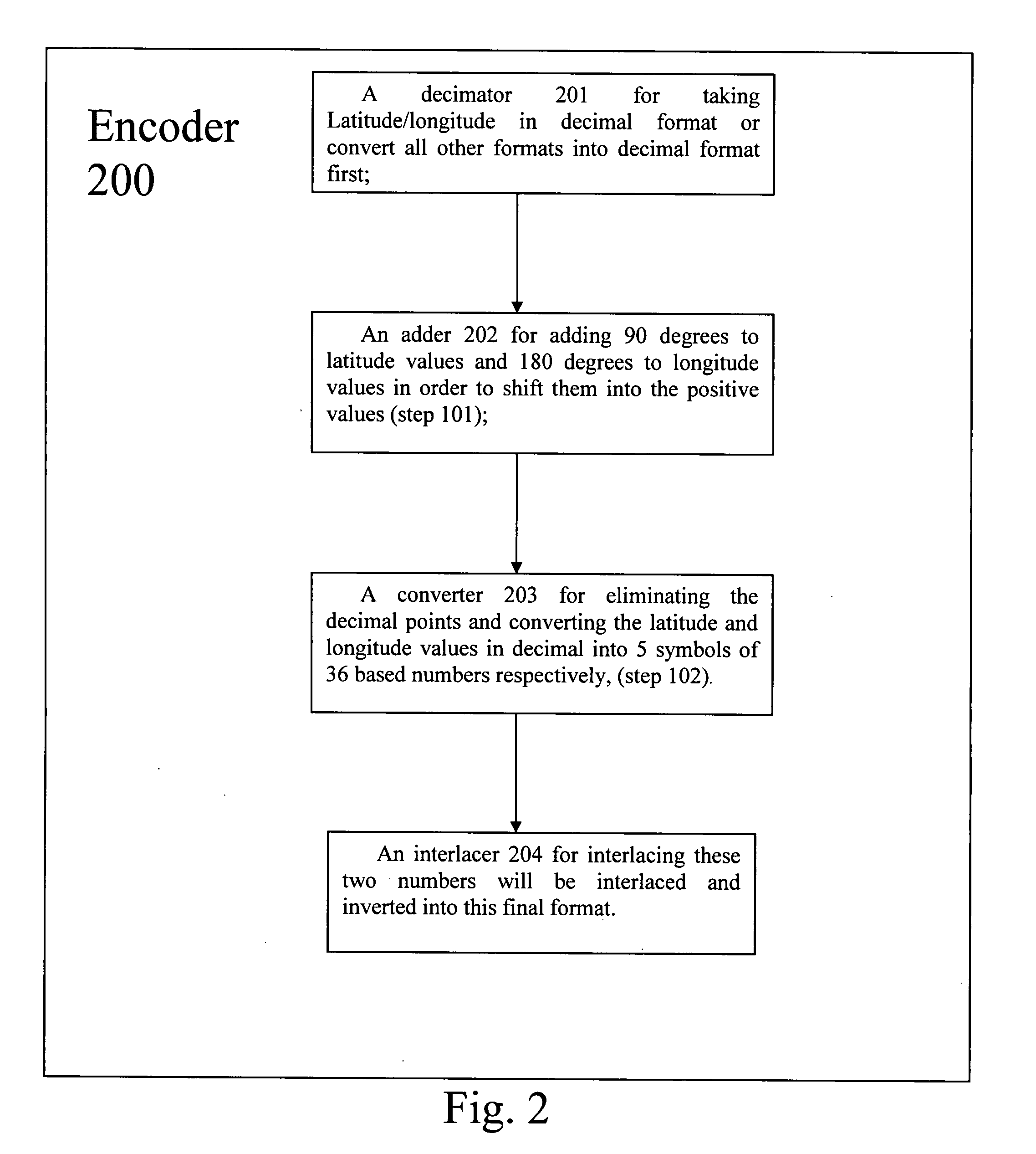
Examples
example 1
[0020]Conventional latitude / longitude values in decimal format with 5 digits after decimal point:
Latitude: 20.43567 degrees
Longitude: 101.56789 degrees
20.43567+90=110.43567×100,000=11043567→(6KP9R)36
11043567 / 36=306765 remainder: 27 (R)36
306765 / 36=8521 remainder: 9 (9)36
8521 / 36=236 remainder: 25 (P)36
236 / 36=6 (6)36 remainder: 20 (K)36
101.56789+180=281.56789×100,000=28156789→(GRHX1)36
28156789 / 36=782133 remainder: 1 (1)36
782133 / 36=21725 remainder: 33 (X)36
21725 / 36=603 remainder: 17 (H)36
603 / 36=16 (G) 36 remainder: 27 (R)36
[0021]Take (6KO9Q)36 and (GRHX1)36 interlaced and inverted into final correspondent Universal Geo Numbers=(R19XPHKR6G)36
example 2
[0022]Conventional latitude / longitude values in decimal format with 5 digits after decimal point:
Latitude: 20.43216 degrees
Longitude: 101.56123 degrees
20.43215+90=110.43215×100,000=11043215→(6KP00)36
11043216 / 36=306756 remainder: 0 (0)36
306756 / 36=8521 remainder: 0 (0)36
8521 / 36=236 remainder: 25 (P)36
236 / 36=6 (6)36 remainder: 20 (K)36
101.56123+180=281.56123×100,000=28156123→(GRHEJ)36
28156123 / 36=782114 remainder: 19 (J)36
782114 / 36=21725 remainder: 14 (E)36
21725 / 36=603 remainder: 17 (H)36 b 603 / 36=16 (G)36 remainder: 27 (R)36
[0023]Take (6KO00)36 and (GRHEJ)36 interlaced and inverted into Final correspondent Universal Geo Numbers=(0J0EPHKR6G)36
example 3
[0024]Conventional latitude / longitude values in decimal format with 5 digits after decimal point:
Latitude: −20.43567 degrees
Longitude: −101.56789 degrees
−20.43567+90=70.43567×100,000=7043567→(46YUM)36
7043567 / 36=195654 remainder: 23 (M)36
195654 / 36=5434 remainder: 30 (U)36
5434 / 36=150 remainder: 34 (Y)36
150 / 36=4(4) 36 remainder: 6 (6)36
−101.56789+180=78.43211×100,000=7843211→(403UZ)36
7843211 / 36=217866 remainder: 35 (Z)36
217866 / 36=6051 remainder: 30 (U)36
6051 / 36=168 remainder: 3 (3)36
168 / 36=4 (4)36 remainder: 24 (O)36
[0025]Take (46YUM)36 AND (403UZ)36 interlaced and inverted into Final correspondent Universal Geo Numbers=(MZUUY36O44)36
[0026]The first two examples show the neighborhood effect of this arithmetical conversion. That means for most people within a town or area the universal geo numbers only differ by first 4 numbers. This will make inputting the numbers into the navigation equipments much easy and fast for people finding other addresses in the nearby area. The thi...
PUM
 Abstract
Description
Claims
Application Information