
Traffic situation determination systems, methods, and programs

Inactive Publication Date: 2008-10-30
AISIN AW CO LTD
View PDF6 Cites 23 Cited by
  • Summary
  • Abstract
  • Description
  • Claims
  • Application Information

AI Technical Summary

Benefits of technology

[0008]Generally, when transmitting information relating to the current position of a vehicle and the like to an information center from the vehicle, the transmission is performed via a communication terminal such as a mobile phone or a PHS (Personal Handyphone System) provided in the vehicle. However, to transmit the information, the number of times that communication is required and the amount of communication data can become extremely large, thereby resulting in high communication fees. This is especially the case if the information relating to the current position and the like of the vehicle is constantly transmitted to the information center while the vehicle is running. On the other hand, the reliability of the traffic information generated in the information center decreases if only limited data is transmitted a limited number of times.
[0009]Furthermore, the accuracy of the specification of the vehicle position based on a mobile phone communication network is low. As a result, the reliability of traffic information decreases when the traffic information is generated-based only on a vehicle position based on a mobile phone communication network.
[0010]Various exemplary implementations of the broad principles disclosed herein provide devices, methods, and programs that can maintain the accuracy of travel path information of the vehicle used for determining traffic jam situations, thereby accurately determining traffic jam situations, decreasing the number of times of communication and the amount of communication data for communication between the vehicle and an information center, and reducing a communication processing load and communication fees.

Problems solved by technology

However, to transmit the information, the number of times that communication is required and the amount of communication data can become extremely large, thereby resulting in high communication fees.
Furthermore, the accuracy of the specification of the vehicle position based on a mobile phone communication network is low.

Method used


Image

  • Traffic situation determination systems, methods, and programs
  • Traffic situation determination systems, methods, and programs
  • Traffic situation determination systems, methods, and programs

Examples


Embodiment Construction

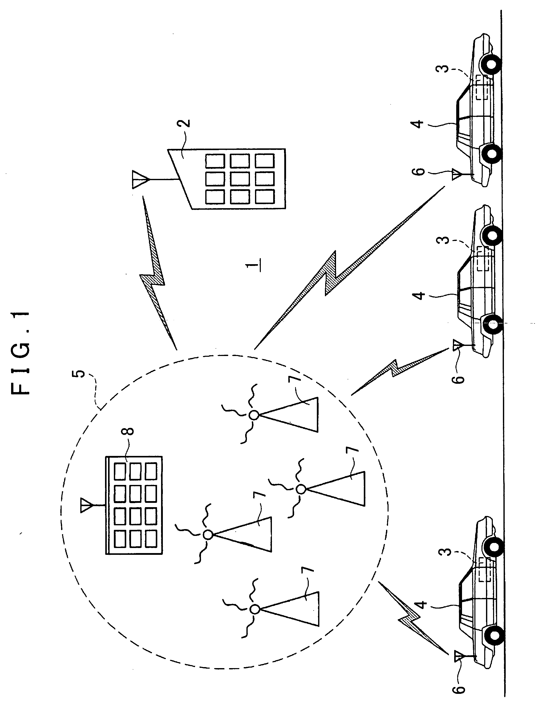
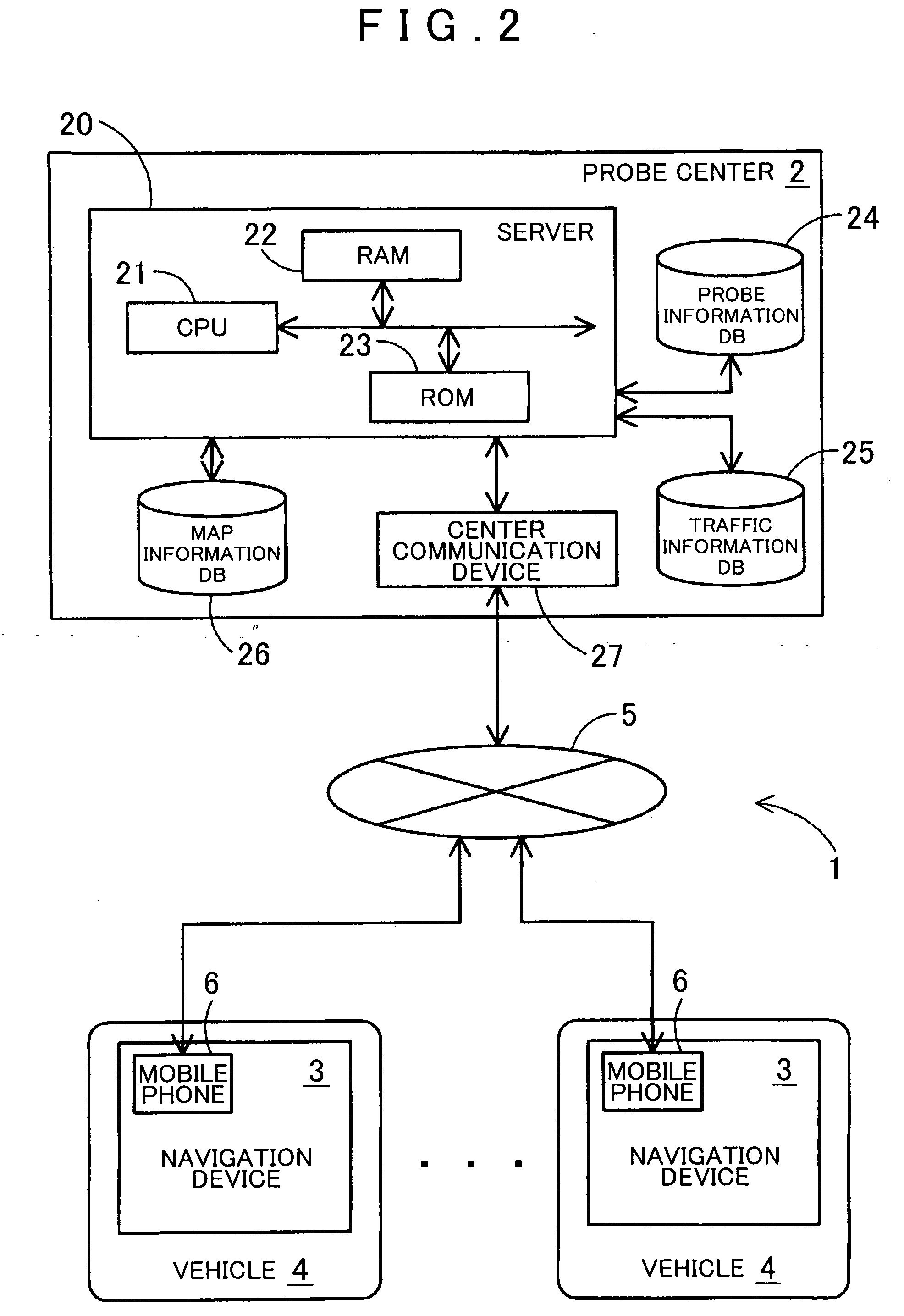
[0019]First, the schematic configuration of an traffic situation determination system 1 according to the present example will be described using FIG. 1. As shown in FIG. 1, the traffic situation determination system 1 according to this example is formed basically of a probe center 2 that gathers probe information and performs generation / delivery of traffic information based on the gathered probe information, a probe car 4 installed with a navigation device 3, and a mobile phone communication network 5 which links mobile phones to enable interactive communication.

[0020]The probe center 2 is a traffic information delivery center that gathers and accumulates the probe information including information relating to the current position of probe cars 4 transmitted from each probe car 4 traveling in various areas of the nation, generates the traffic information such as traffic jam information from the accumulated probe information, and delivers the generated traffic information (hereinafte...


PUM


Abstract

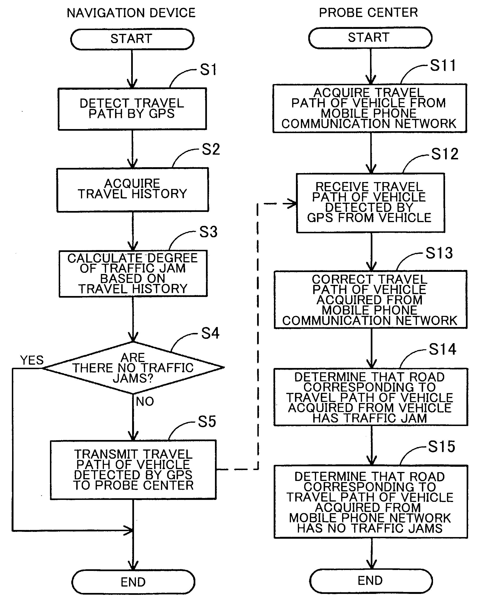
Traffic situation determination systems, methods, and programs acquire a current position of the vehicle based on a radio signal received from a GPS satellite and determine a first travel path of the vehicle based on the acquired position of the vehicle. The systems, methods, and programs determine whether a road on which the vehicle is traveling has a traffic jam. If the road on which the vehicle is traveling has a traffic jam, the systems, methods and programs transmit first information relating to the first travel path from the vehicle to an information center. The systems, methods, and programs receive second information relating to a second travel path of the vehicle, the second information being received from a mobile phone communication center and being based on a mobile phone signal received by the mobile phone communication center. The systems, methods, and programs determine a road corresponding to the first travel path as having a traffic jam and determine a road corresponding to the second travel path, and not corresponding to the first travel path, as having no traffic jam.

Description

INCORPORATION BY REFERENCE[0001]The disclosure of Japanese Patent Application No. 2007-117162, filed on Apr. 26, 2007, including the specification, drawings and abstract is incorporated herein by reference in its entirety.BACKGROUND[0002]1. Related Technical Fields[0003]Related technical fields include traffic situation determination systems, methods, and programs that determine a traffic situation on a road.[0004]2. Related Art[0005]On-vehicle navigation devices, personal digital assistants (PDAs), mobile information devices such as a mobile phone, personal computers, and the like, are capable of displaying a map of a desired area to a user. The maps are displayed by storing information on roads such as a general road and an expressway, facility names, and the like as map information in various storage devices, downloading the map information from a server, and / or the like.[0006]Traffic information such as traffic jam information of a displayed road may also be provided in order to...

Claims


Application Information

Patent Timeline
IPC IPC(8): G08G1/052G01S5/00G01C21/26G08G1/01G08G1/13
CPCG01S5/0027G01S2205/002G08G1/0104
Inventor ISHIKAWA, HIROKIYAMAMOTO, YUKIOKANO, TOSHIHIRO
Owner AISIN AW CO LTD
Learn More