Automatic Blade Control System with Integrated Global Navigation Satellite System and Inertial Sensors

Active Publication Date: 2009-03-12
TOPCON POSITIONING SYST INC
View PDF13 Cites 96 Cited by
  • Summary
  • Abstract
  • Description
  • Claims
  • Application Information

AI Technical Summary

Benefits of technology

[0004]In an embodiment, the blade elevation and blade slope angle of a dozer blade are controlled based at least in part on measurements received from at least one global navigation satellite system (GNSS) sensor and at least one inertial sensor mounted on the dozer blade. In an embodiment, one or two antennas receiving GNSS signals are mounted on a pole fixed to the dozer blade. An inertial measurement unit is also mounted on the dozer blade. The inertial measurement unit include

Problems solved by technology

Although a control system using only a GNSS sensor for positioning may result in appropriate grading quality in some types of machines, such as graders and scrapers, it has certain limitations in other types of machines, such a

Method used


Image

  • Automatic Blade Control System with Integrated Global Navigation Satellite System and Inertial Sensors
  • Automatic Blade Control System with Integrated Global Navigation Satellite System and Inertial Sensors
  • Automatic Blade Control System with Integrated Global Navigation Satellite System and Inertial Sensors

Examples


Embodiment Construction

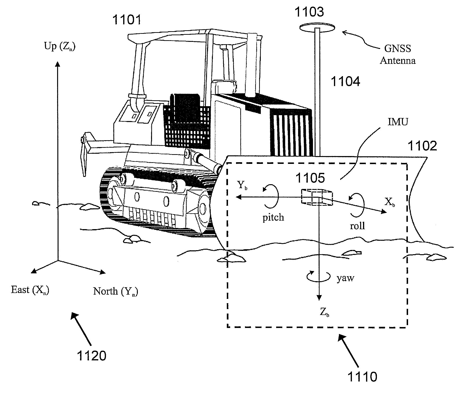
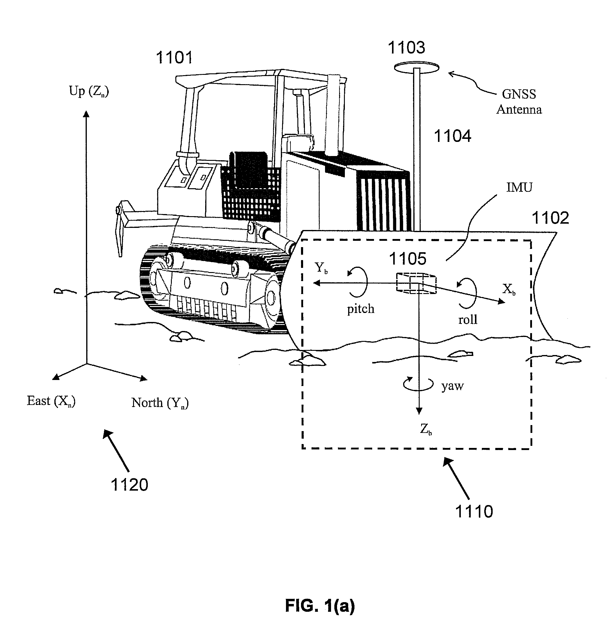
[0016]FIG. 1(a)-FIG. 1(d) illustrate the dozer configuration and reference frames used in the discussions below. In FIG. 1(a), dozer body 1101 is equipped with dozer blade 1102. The front side of dozer blade 1102 faces away from dozer body 1101. Global Navigation Satellite System (GNSS) antenna 1103 is mounted on pole 1104, which is fixed to dozer blade 1102. In an embodiment, a second GNSS antenna may be mounted on a pole fixed to dozer blade 1102. Inertial measurement unit IMU 1105 is installed on the rear side of dozer blade 1102 (facing towards dozer body 1101). A GNSS receiver (not shown) may be installed in the cabin of dozer body 1101. A control box (not shown) may also be installed in the cabin of dozer body 1101. Further details of the control box are discussed below.

[0017]In FIG. 1(a), the navigation frame 1120 is a Cartesian coordinate system used as a local navigation frame. The axes of the navigation frame 1120 are denoted ENU [East (Xn), North (Yn), Up (Zn)]. The Xn-Yn...


PUM


Abstract

Disclosed are method and apparatus for controlling the blade elevation and blade slope angle of a dozer blade. Elevation and slope angle measurements are calculated from measurements received from a global navigation satellite system (GNSS) antenna and an inertial measurement unit mounted on the dozer blade. The inertial measurement unit includes three orthogonally placed accelerometers and three orthogonally placed rate gyros. The measurements are processed by algorithms to calculate estimates of the blade elevation, blade vertical velocity, blade slope angle, and blade slope angular velocity. These estimates are then provided as inputs to a control algorithm which provides control signals to control a dozer hydraulic system which controls the blade elevation and blade slope angle.

Description

[0001]This application claims the benefit of U.S. Provisional Application No. 60 / 993,713 filed Sep. 12, 2007, which is incorporated herein by reference.BACKGROUND OF THE INVENTION[0002]The present invention relates generally to earth-grading machines, and more particularly to an automatic blade control system for dozers.[0003]Global Navigation Satellite System (GNSS) sensors have been extensively used in the area of construction machine control, particularly in grading applications. Although a control system using only a GNSS sensor for positioning may result in appropriate grading quality in some types of machines, such as graders and scrapers, it has certain limitations in other types of machines, such as dozers. A combination of a GNSS sensor with a proportional controller, commonly found in dozer blade control systems, often results in specific wave-like patterns on the ground after grading, particularly at high dozer speeds. What are needed are method and apparatus for more pre...

Claims


Application Information

Patent Timeline
IPC IPC(8): G06F19/00G01S19/10G01S19/04G01S19/14G01S19/44G01S19/46G01S19/47
CPCE02F3/842E02F3/847G01S19/47G01S19/14E02F9/2045
Inventor OMELCHENKO, ALEXANDERZHDANOV, ALEXEY VLADISLAVOVICH
Owner TOPCON POSITIONING SYST INC
Why Eureka
Try Eureka