Processing Multi-GNSS data from mixed-type receivers

a multi-gnss and receiver technology, applied in satellite radio beaconing, measurement devices, instruments, etc., can solve problems such as network data processing and data post-processing, and structure implemented in glonass

Active Publication Date: 2009-07-23
TRIMBLE NAVIGATION LTD
View PDF9 Cites 99 Cited by
  • Summary
  • Abstract
  • Description
  • Claims
  • Application Information

AI Technical Summary

Benefits of technology

[0007]Improved methods and apparatus in accordance with some embodiments of the

Problems solved by technology

The signal structure implemented in GLONASS presents problems for RTK dat

Method used


Image

  • Processing Multi-GNSS data from mixed-type receivers
  • Processing Multi-GNSS data from mixed-type receivers
  • Processing Multi-GNSS data from mixed-type receivers

Examples


Embodiment Construction

Overview

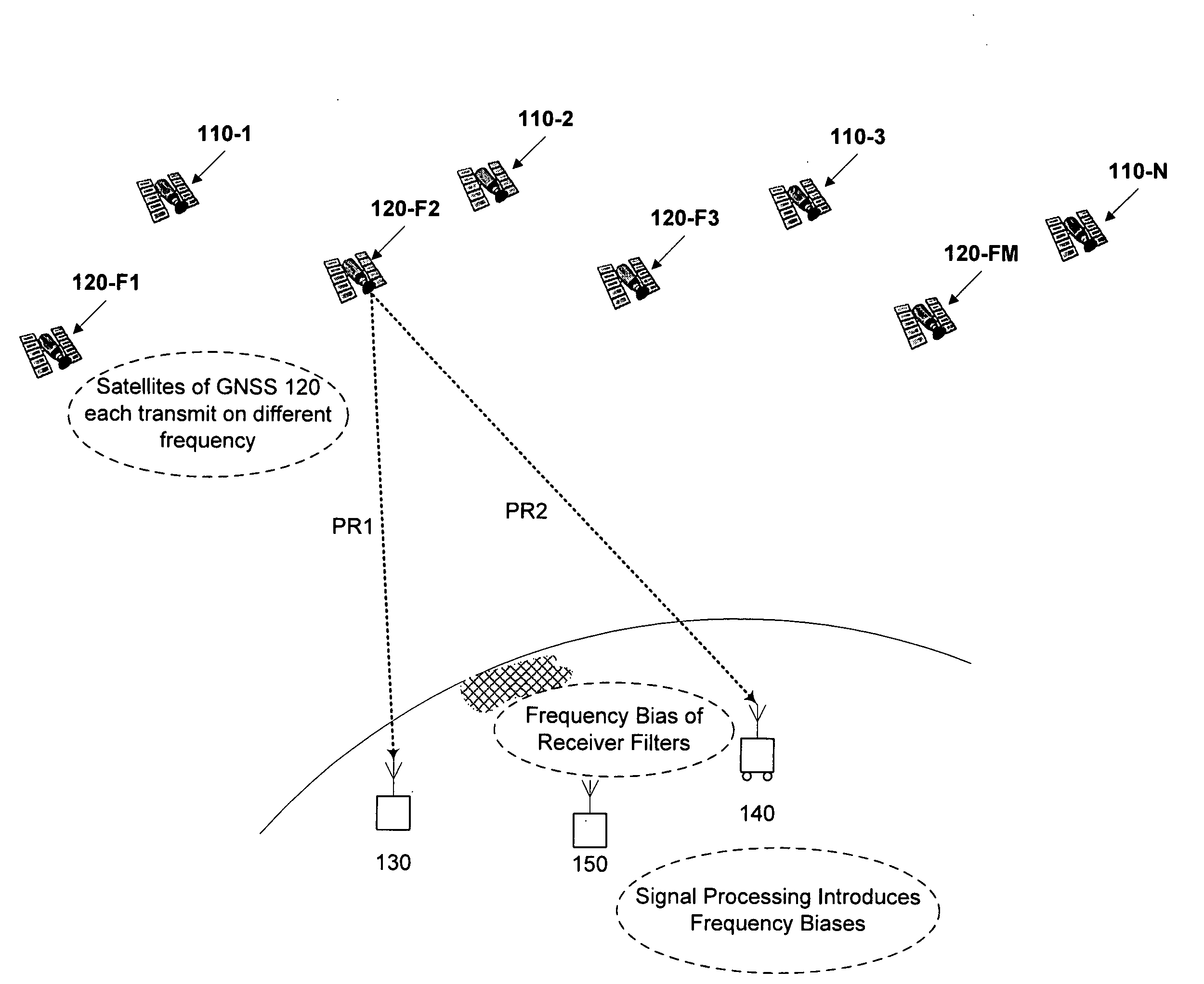
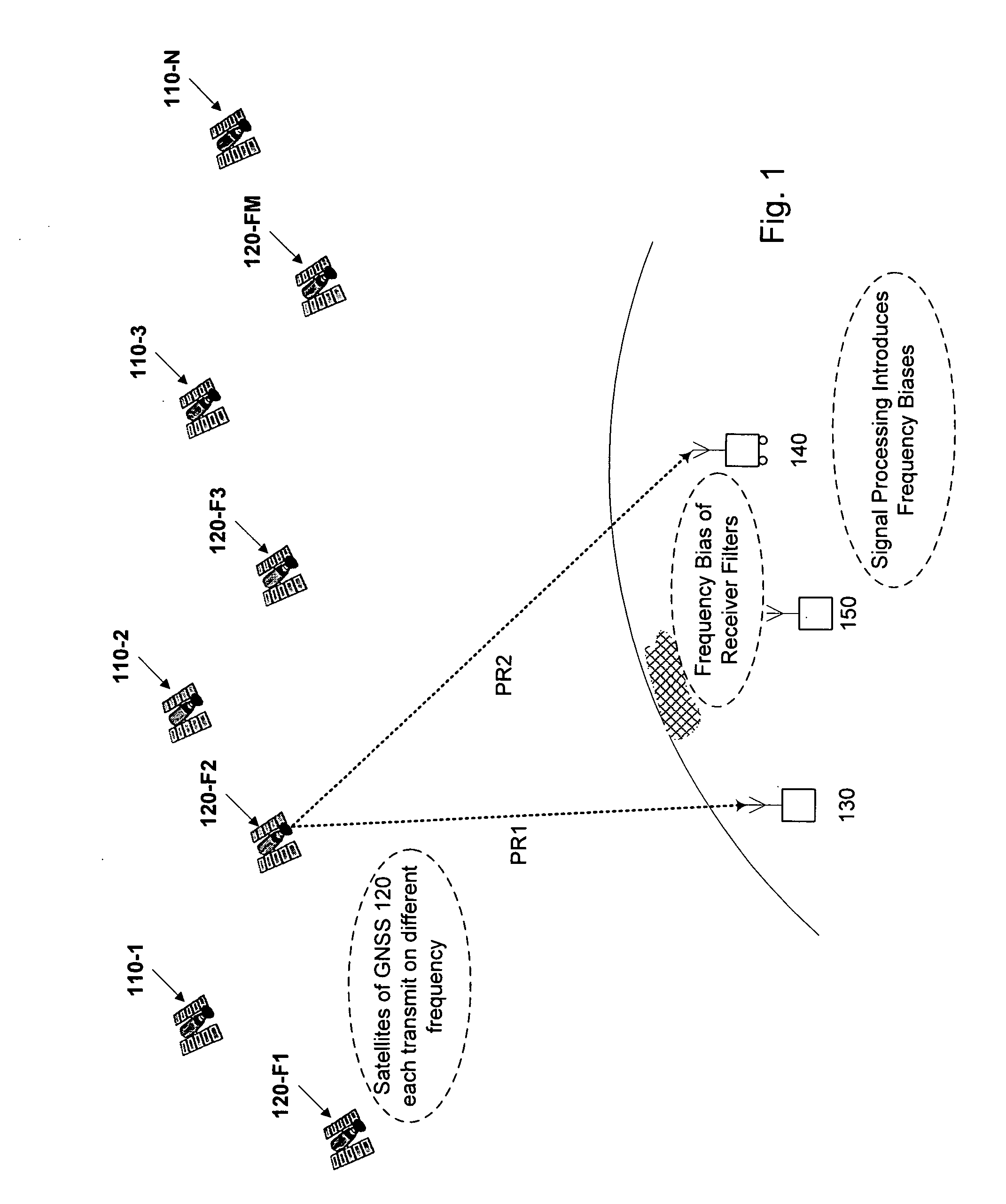
[0030]FIG. 1 schematically illustrates a scenario using two GNSS (110, 120) with receivers of different types having different frequency biases, such as a reference station 130 from a first manufacturer and a rover 140 from a second manufacturer. GNSS 110 is a CDMA system such as GPS. GNSS 120 is an FDMA system such as GLONASS. Reference station 130, rover 140, and one or more additional reference stations 150, if provided, each receive GNSS signals from any number of satellites of a first GNSS, such as satellites 110-1, 110-2, . . . , 110-N, and from any number of satellites of a second GNSS, such as satellites 120-1, 120-2, . . . , 120-M. Respective pseudoranges, PR1, PR2, etc. from each satellite are to be determined from GNSS signal data collected at the receivers.

[0031]Pseudo-range can be determined for example using the GPS C / A code with an error of about one meter. A civil GPS receiver not using the military-only P / Y code determines rover position with an error in the...


PUM


Abstract

Computer-implemented methods and apparatus are presented for processing data collected by at least two receivers from multiple satellites of multiple GNSS, where at least one GNSS is FDMA. Data sets are obtained which comprise a first data set from a first receiver and a second data set from a second receiver. The first data set comprises a first FDMA data set and the second data set comprises a second FDMA data set. At least one of a code bias and a phase bias may exist between the first FDMA data set and the second FDMA data set. At least one receiver-type bias is determined, to be applied when the data sets are obtained from receivers of different types. The data sets are processed, based on the at least one receiver-type bias, to estimate carrier floating-point ambiguities. Carrier integer ambiguities are determined from the floating-point ambiguities. The scheme enables GLONASS carrier phase ambiguities to be resolved and used in a combined FDMA/CDMA (e.g., GLONASS/GPS) centimeter-level solution. It is applicable to real-time kinematic (RTK) positioning, high-precision post-processing of positions and network RTK positioning.

Description

CROSS REFERENCE TO RELATED APPLICATIONS[0001]This application claims benefit of U.S. Provisional Application for Patent No. 61 / 010,601, filed Jan. 9, 2008, the content of which is incorporated herein by this reference.[0002]The content of U.S. patent application: VOLLATH U., “Ambiguity Estimation of GNSS Signals for Three or more Carriers,” application Ser. No. 10 / 696,528 filed Oct. 28, 2003, Pub. No.: US 2005 / 0101248 A1 published May 12, 2005 is incorporated herein by this reference. The content of U.S. Pat. No. 7,312,747, VOLLATH U. and DOUCET K., “Multiple-GNSS and FDMA High-Precision Carrier-Phase Based Positioning,” dated Dec. 25, 2007 is incorporated herein by this reference.FIELD OF THE INVENTION[0003]The present invention relates to the field of Global Navigation Satellite Systems. More particularly, the present invention relates to processing of data collected by at least two receivers from multiple satellites of multiple GNSS where at least one GNSS is FDMA and there is at...

Claims


Application Information

Patent Timeline
IPC IPC(8): G01S5/14G01S19/44
CPCG01S19/04G01S19/44G01S19/33
Inventor TALBOT, NICHOLASVOLLATH, ULRICHLU, GANG
Owner TRIMBLE NAVIGATION LTD
Why Eureka
Try Eureka