Apparatus and method for automatic airborne LiDAR data processing and mapping using data obtained thereby

a lidar data and automatic processing technology, applied in the field of lidar and aerial mapping, can solve the problems of low accuracy, low final product cost, and lack of software tools that automatically and efficiently process lidar data

Active Publication Date: 2009-07-23
TILTAN SYST ENG
View PDF7 Cites 98 Cited by
  • Summary
  • Abstract
  • Description
  • Claims
  • Application Information

AI Technical Summary

Problems solved by technology

Km acquires approximately 2*1010 data points to be processed, and one of the issues preventing widespread acceptance of LiDAR is the lack of software tools that automatically and efficiently process the LiDAR data.
Thus huge numbers of man-hours are spent on LiDAR data, making the final product very expensive.

Method used


Image

  • Apparatus and method for automatic airborne LiDAR data processing and mapping using data obtained thereby
  • Apparatus and method for automatic airborne LiDAR data processing and mapping using data obtained thereby
  • Apparatus and method for automatic airborne LiDAR data processing and mapping using data obtained thereby

Examples


Embodiment Construction

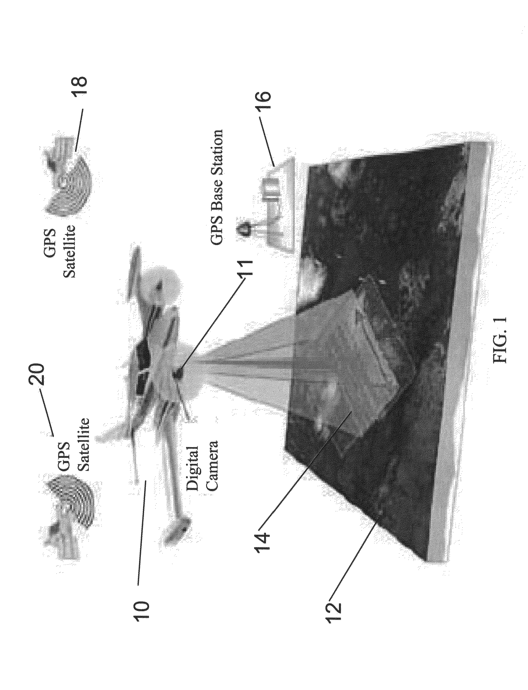
[0045]The present invention, in some embodiments thereof, relates to LiDAR and aerial mapping of ground topography, and more particularly but not exclusively to a mapping process using data obtained from the LiDAR sensor.

[0046]The raw LiDAR data may be inserted into a bare earth filter unit which calculates ground height over the data, bearing in mind that topography can vary over the data gathering area. Once ground height is calculated then all points relating to the ground are removed to leave only those points relating to features superimposed on the ground such as trees and buildings. These features may then be resolved into specific objects. Then the data points identified as these specific objects can be automatically replaced by virtual versions of the objects.

[0047]The result may then be included in a 3D model.

[0048]The result of the above processing may then be presented to the specialist to confirm, add or correct the result using a graphical interface, which also allows ...


PUM


Abstract

Apparatus for processing of a LiDAR point cloud of a ground scan, comprises: a point cloud input for receiving said LiDAR point cloud, a ground filter for filtering out points that belong to the ground from said point cloud, thereby to generate an elevation map showing features extending from the ground, an automatic feature search and recognition unit associated with said three dimensional graphical engine for searching said elevation map of said three-dimensional model to identify features therein and to replace points associated with said feature with a virtual object representing said feature, thereby to provide objects within said data; and a three-dimensional graphical renderer supporting three-dimensional graphics, to generate a three-dimensional rendering of said ground scan.

Description

FIELD AND BACKGROUND OF THE INVENTION[0001]The present invention, in some embodiments thereof, relates to LiDAR and aerial mapping of the ground topography, and more particularly but not exclusively to the mapping process using the data obtained from the LiDAR sensor.[0002]LiDAR, an acronym for Light Detection and Ranging, is a sensor that enables rapid generation of dense, accurate, digital models of the topography and vertical structure of a target surface.[0003]The airborne LiDAR laser sensor is mounted on the underside of an aircraft. It transmits pulses of narrow laser beam towards the earth as the aircraft flies. A receiver affixed to the aircraft receives reflections of the pulses as they bounce off the ground surface, and objects on the ground, back to the aircraft. Most LiDAR systems use a scanning mirror to generate a swath of light pulses. Swath width depends on the mirror's angle of oscillation, and the ground-point density depends on factors such as aircraft speed and m...

Claims


Application Information

Patent Timeline
Patent Type & Authority Applications(United States)
IPC IPC(8): G06K9/00G01S17/89G06V20/13
CPCG06K9/0063G01S17/89G01C15/002G06V20/13
Inventor NAHARI, ALONMENAKER, EHUDNAHARI, OFERNEIMAN, ELIGUSIS, VADIM
Owner TILTAN SYST ENG
Why Eureka
Try Eureka