Method for making a land management decision based on processed elevational data

a technology of elevation data and land management decision, applied in the field of land management decision making, can solve the problems of in-field analysis expense of sampling techniques or delay of laboratory soil analysis,

Inactive Publication Date: 2009-10-15
DEERE & CO
View PDF9 Cites 79 Cited by
  • Summary
  • Abstract
  • Description
  • Claims
  • Application Information

AI Technical Summary

Problems solved by technology

However, such soil sampling techniques require the expense o...

Method used


Image

  • Method for making a land management decision based on processed elevational data
  • Method for making a land management decision based on processed elevational data
  • Method for making a land management decision based on processed elevational data

Examples


Embodiment Construction

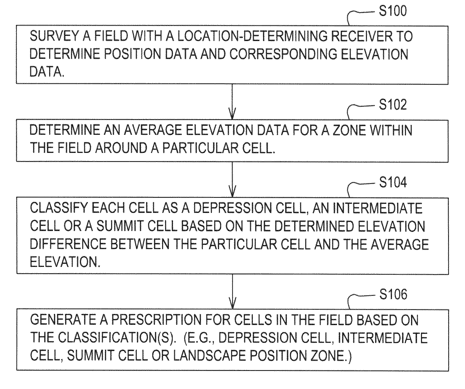
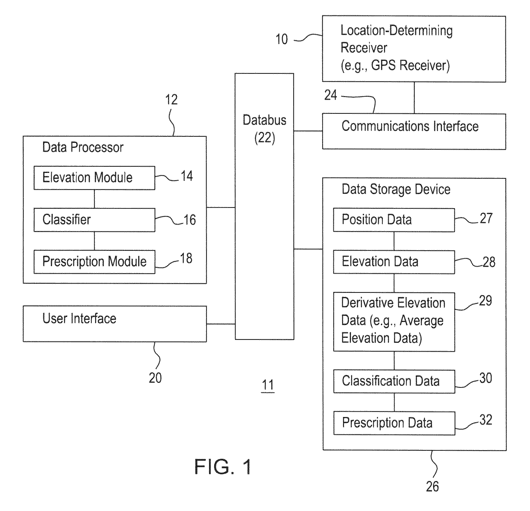
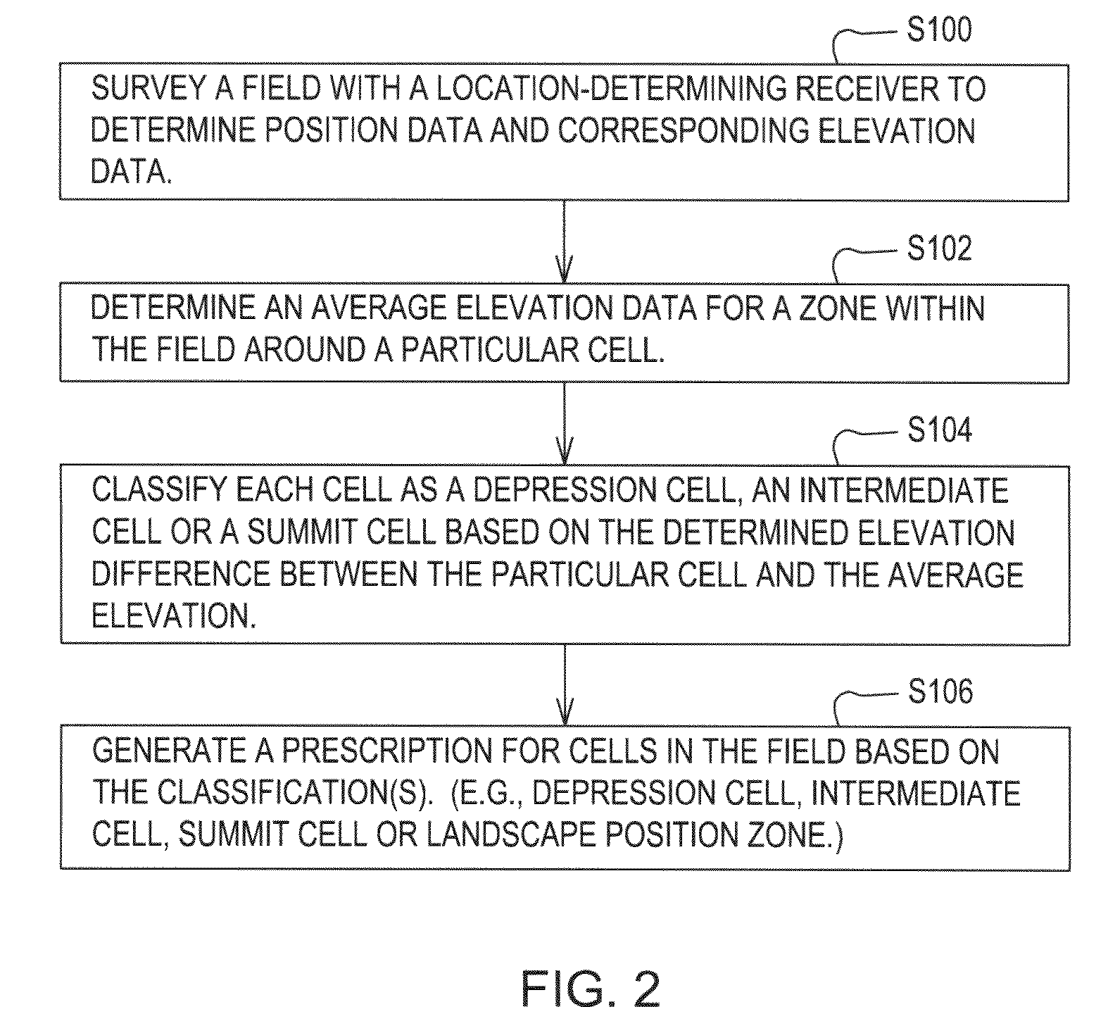
[0020]In accordance with one embodiment of the invention, FIG. 1 illustrates a system 11 for making land management decisions (e.g., agricultural or agronomic decisions, water drainage decisions, or construction decisions) based on processed elevation data. A land management decision refers to any decision, design or plan that relates to management of a plot or area of land, including, but not limited to, agricultural decisions, crop treatment plans, application of agricultural inputs (e.g., pesticides, herbicides, fungicides, nutrients, water or fertilizer), construction plans (e.g., for roads, buildings, bridges, or other structures), and land sculpting plans, land shaping plans, land leveling plans and environmental remediation plans (e.g., construction of parks or golf courses).

[0021]The system 11 of FIG. 1 comprises a location-determining receiver 10 coupled to a communications interface 24. In turn, the communications interface 24 is coupled to a data bus 22. A data processor ...


PUM


Abstract

A method for making a land management decision comprises surveying a field with a location-determining receiver to determine position data and corresponding elevation data. A data processor or elevation module determines an average elevation data for a zone within the field around a particular cell. The data processor or classifier classifies each cell into classifications comprising a depression cell and a summit cell based on the determined elevation difference between the particular cell and the average elevation. The data processor and the prescription module generate a prescription for the cells in the field based on at least one of the classification and the determined elevation difference.

Description

[0001]This document (including the drawings) claims the benefit of the filing date of U.S. Provisional Application No. 61 / 044,158, filed Apr. 11, 2008, under 35 U.S.C. 119(e).FIELD OF THE INVENTION [0002]This invention relates to a method for making a land management decision (e.g., agricultural decision) based on processed elevation data.BACKGROUND OF THE INVENTION [0003]Farmers, crop consultants and others have used conventional soil surveys to manage the application of various crop inputs. In one example, soil may be collected on a grid basis and analyzed in a laboratory to determine nutrient levels, water holding capacity, clay content, and organic matter content, or other soil characteristics of interest. In another example, in situ soil sampling techniques may rely upon mobile testing, which might involve in-field optical or spectroscopic analysis of the collected samples. However, such soil sampling techniques require the expense of in-field analysis or potential delay of lab...

Claims


Application Information

Patent Timeline
IPC IPC(8): G06Q99/00
CPCG06Q10/06G06Q50/165G06Q50/02
Inventor HENDRICKSON, LARRY LEECLARK, RENDEL B.
Owner DEERE & CO
Why Eureka
Try Eureka