System and method for eliminating confusion between weather data and terrain data in aircraft displays

a technology of aircraft display and weather data, applied in surveying and navigation, navigation instruments, instruments, etc., can solve the problems of increasing the potential for unsafe flight conditions, pilot confusion, etc., to reduce and/or eliminate confusion, reduce pilot confusion, and control the length of time

Inactive Publication Date: 2010-02-11
HONEYWELL INT INC
View PDF7 Cites 23 Cited by
  • Summary
  • Abstract
  • Description
  • Claims
  • Application Information

AI Technical Summary

Benefits of technology

[0004]The present invention provides an improved system and method for eliminating pilot confusion in visualizing multiple categories of data, such as, for example, weather data and terrain data, simultaneously on an integrated, multi-color display. In accordance with a preferred embodiment of the present invention, an aircraft display system is provided that includes a processing unit, a terrain database, a weather data source, a visual display for displaying multi-color weather data and terrain data, and a control device for controlling the duration of the weather data being shown on the visual display. For this example embodiment, as an aircraft proceeds along a flight path, the processing unit retrieves and / or receives weather data from the weather data source and terrain data from the terrain database. The processing unit provides color renderings of the terrain data to the visual display. The processing unit determines a time duration for the weather data from a setting of the control device (e.g., set by a pilot), and provides color renderings of the weather data to the visual display for the selected time duration. For example, the weather data sweep on the display can become narrower or wider depending on the time duration selected. Also, for example, the trailing edge of the weather data sweep can become more transparent and / or opaque as the sweep becomes narrower. Thus, the present invention allows a pilot to control the length of time that the weather data is being displayed, which reduces and / or eliminates confusion in visualizing the terrain data and weather data being displayed simultaneously on the integrated, multi-color display.

Problems solved by technology

Notwithstanding the significant advantages of the aircraft display disclosed in Dwyer, a significant drawback of existing aircraft displays is that pilots can be confused by the separation of the weather data and terrain data on a display screen.
However, a significant problem with such multi-color displays is that some of the same color codes are used for data in the different data categories being displayed.
This problem of confusion increases the potential for unsafe flight conditions.

Method used


Image

  • System and method for eliminating confusion between weather data and terrain data in aircraft displays
  • System and method for eliminating confusion between weather data and terrain data in aircraft displays
  • System and method for eliminating confusion between weather data and terrain data in aircraft displays

Examples


Embodiment Construction

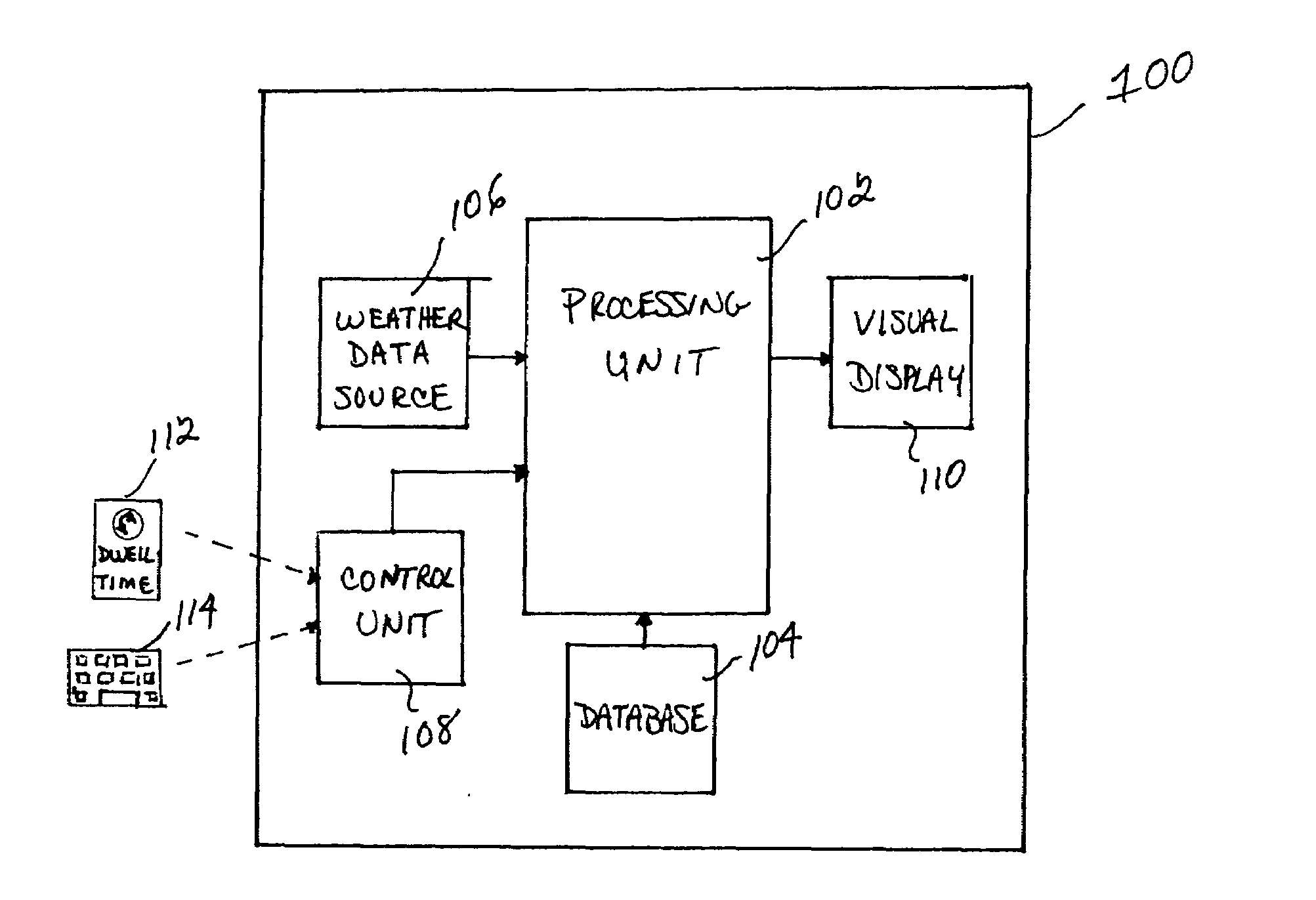
[0009]With reference now to the figures, FIG. 1 depicts a block diagram of an example system 100 for eliminating confusion in visualizing multiple categories of data simultaneously on an integrated, multi-color aircraft display, which can be used to implement a preferred embodiment of the present invention. For this example, system 100 includes a processing unit 102, a database 104, a weather data source 106, a control unit 108, and a visual display 110. Notably, it should be understood that although system 100 appears in FIG. 1 to be arranged as an integrated system, the present invention is not intended to be so limited and can also include an arrangement whereby one or more of processing unit 102, database 104, weather data source 106, control unit 108 and visual display 110 is a separate component or a subcomponent of another system located either onboard or external to an aircraft. Also, for example, system 100 can be arranged as an integrated system (e.g., aircraft display sys...


PUM


Abstract

An improved system and method are disclosed for eliminating pilot confusion in visualizing multiple categories of data, such as, for example, weather data and terrain data, simultaneously on an integrated, multi-color display. For example, an aircraft display system is disclosed that includes a processing unit, a terrain database, a weather data source, a visual display for displaying multi-color weather data and terrain data, and a control device for controlling the duration of the weather data being shown on the visual display. As an aircraft proceeds along a flight path, the processing unit retrieves and / or receives weather data from the weather data source and terrain data from the terrain database. The processing unit provides color renderings of the terrain data to the visual display. The processing unit determines a time duration for the weather data from a setting of the control device (e.g., set by a pilot), and provides color renderings of the weather data to the visual display for the selected time duration. For example, the weather data sweep on the display can become narrower or wider depending on the time duration selected. Also, for example, the trailing edge of the weather data sweep can become more transparent and / or opaque as the sweep becomes narrower. Thus, the pilot is allowed to control the length of time that the weather data is being displayed, which reduces and / or eliminates confusion in visualizing the terrain data and weather data being displayed simultaneously on the integrated, multi-color display.

Description

FIELD OF THE INVENTION[0001]The invention relates generally to the field of display systems, and more specifically, but not exclusively, to a system and method for eliminating confusion between weather data and terrain data in aircraft displays.BACKGROUND OF THE INVENTION[0002]Aircraft displays have become highly sophisticated and are capable of displaying a substantial amount of information, such as, for example, weather information and terrain information. The weather information shown on an aircraft's display is typically airborne weather information depicting adverse weather conditions, such as, for example, clouds, rain, ice or snow storms, thunderstorms, clear air turbulence, wind shear, microbursts, etc. Such weather information may be received from an onboard weather radar system and / or one or more external ground-based or satellite-based weather information sources. The terrain information shown on an aircraft's display is typically situational awareness terrain information...

Claims


Application Information

Patent Timeline
Patent Type & Authority Applications(United States)
IPC IPC(8): G09G5/00G01S13/95
CPCG01C23/005G09G2380/12G09G5/00G01S7/04
Inventor GANNON, AARON J.MCCAULEY, SHEPHEN G.
Owner HONEYWELL INT INC
Why Eureka
Try Eureka